Difference between revisions of "2021-01-18 46 4"
(Created page with "{{meetup graticule | lat = 46 | lon = 4 | date = 2021-01-18 }} == Location == In the vineyards near wikipedia:Fleurie. == Participants == * Baarde...") |
m (→Achievements: Update ribbon width) |
||
| (3 intermediate revisions by 2 users not shown) | |||
| Line 14: | Line 14: | ||
== Expedition == | == Expedition == | ||
| + | I took the 13:34 train from Lyon to Mâcon and arrived at Romanèche-Thorins train station at 14:11. I walked along the road to Fleurie for a few hundreds meters then took a parallel path through the fields and reached the coordinates, at the edge of a vineyard, 50 minutes later. | ||
| + | |||
| + | After recording proof I noticed a nearby chapel on top of a hill overlooking the village. As I add some time on my hands, I decided to have a look. Near the chapel, I found the [https://www.geocaching.com/geocache/GC1RTVA GC1RTVA] geocache below a cherry tree. Tough technically within sight, the cherry was 1.14 km from the geohash, so I didn't get the [[Hash collision]] honorable mention. | ||
| + | |||
| + | Then I walked back to the train station. | ||
== Photos == | == Photos == | ||
| + | <gallery> | ||
| + | Image:2021-01-18 46 4 01.jpg | At the train station | ||
| + | Image:2021-01-18 46 4 02.jpg | At the geohash | ||
| + | Image:2021-01-18 46 4 03.png | Coordinates reached | ||
| + | Image:2021-01-18 46 4 04.jpg | View from the geohash | ||
| + | Image:2021-01-18 46 4 05.jpg | Stupid grin | ||
| + | Image:2021-01-18 46 4 06.jpg | At the chapel | ||
| + | Image:2021-01-18 46 4 07.jpg | Passing through Fleurie | ||
| + | Image:2021-01-18 46 4 08.jpg | My ride back home | ||
| + | </gallery> | ||
== Achievements == | == Achievements == | ||
| − | {{#vardefine:ribbonwidth| | + | {{#vardefine:ribbonwidth|100%}} |
| + | {{land geohash | ||
| + | | latitude = 46 | ||
| + | | longitude = 4 | ||
| + | | date = 2021-01-18 | ||
| + | | name = [[User:Baarde|Baarde]] | ||
| + | }} | ||
__NOTOC__ | __NOTOC__ | ||
[[Category:Expeditions]] | [[Category:Expeditions]] | ||
| + | [[Category:Expeditions with photos]] | ||
| + | [[Category:Coordinates reached]] | ||
| + | {{location|FR|69}} | ||
Latest revision as of 15:42, 4 May 2021
| Mon 18 Jan 2021 in 46,4: 46.1856815, 4.6870272 geohashing.info google osm bing/os kml crox |
Location
In the vineyards near Fleurie.
Participants
Plans
I will take the train to Romanèche-Thorins and walk from there to the geohash. I should reach the coordinates around 15:00.
Expedition
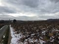
I took the 13:34 train from Lyon to Mâcon and arrived at Romanèche-Thorins train station at 14:11. I walked along the road to Fleurie for a few hundreds meters then took a parallel path through the fields and reached the coordinates, at the edge of a vineyard, 50 minutes later.
After recording proof I noticed a nearby chapel on top of a hill overlooking the village. As I add some time on my hands, I decided to have a look. Near the chapel, I found the GC1RTVA geocache below a cherry tree. Tough technically within sight, the cherry was 1.14 km from the geohash, so I didn't get the Hash collision honorable mention.
Then I walked back to the train station.
Photos
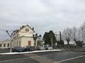
At the train station
At the geohash
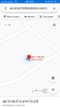
Coordinates reached
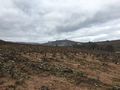
View from the geohash
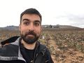
Stupid grin
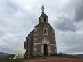
At the chapel
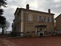
Passing through Fleurie
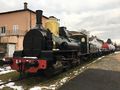
My ride back home


Achievements
Baarde earned the Land geohash achievement
|