Difference between revisions of "2021-01-31 21 -102"
(→Plans) |
m (per Renaming Proposal) |
||
| (13 intermediate revisions by 3 users not shown) | |||
| Line 1: | Line 1: | ||
| − | + | {{meetup graticule | |
| − | |||
| − | |||
| − | |||
| − | |||
| − | |||
| − | |||
| − | |||
| − | |||
| lat=21 | | lat=21 | ||
| lon=-102 | | lon=-102 | ||
| date=2021-01-31 | | date=2021-01-31 | ||
| − | }} | + | }} |
__NOTOC__ | __NOTOC__ | ||
== Location == | == Location == | ||
| − | + | Acceso sur a la ciudad de Aguascalientes, afuera de plaza vestir | |
== Participants == | == Participants == | ||
| − | + | * [[User:Afiag|Afiag]] ([[User talk:Afiag|talk]]) | |
== Plans == | == Plans == | ||
| Line 23: | Line 15: | ||
== Expedition == | == Expedition == | ||
| − | + | Fue un viaje muy sencillo, tome un taxy que me llevo al lugar, una vez ahí descubrí que el punto se encontraba en medio de una avenida, por lo que simplemente cruce la calle hacia el camellón, una zona muy arbolada, no había muchos autos transitando, así que fue muy sencillo, me dispuse a tomar la fotografía cuando inadvertidamente fui atacado por un Raptor, afortunadamente solo recibí unos pequeños rasguños pero pude escapar sano y salvo. | |
| − | |||
| − | |||
| − | |||
== Photos == | == Photos == | ||
| − | < | + | <gallery> |
| − | Image: | + | Image:953.jpg |
| − | + | Image:2021-01-31_21_-102_afiag_1612132249953.jpg|Momentos antes de la tragedia [https://openstreetmap.org/?lat=21.83980290&lon=-102.28983810&zoom=16&layers=B000FTF @21.8398,-102.2898] | |
| − | + | Image:Rasguño.jpg|Consecuencias | |
| − | |||
| − | Image:2021-01-31_21_-102_afiag_1612132249953.jpg| | ||
</gallery> | </gallery> | ||
== Achievements == | == Achievements == | ||
{{#vardefine:ribbonwidth|800px}} | {{#vardefine:ribbonwidth|800px}} | ||
| − | |||
| − | |||
| − | |||
| − | |||
| − | |||
| − | + | {{land geohash | latitude = 21 | longitude = -102 | date = 2021-01-31 | name = Afiag | image = 2021-01-31 21 -102 afiag 1612132249953.jpg}} | |
| − | + | {{Graticule unlocked | latitude = 21 | longitude = -102 | date = 2021-01-31 | name = Afiag | image = 2021-01-31 21 -102 afiag 1612132249953.jpg}} | |
| − | |||
| − | |||
| − | |||
| − | + | {{Velociraptor geohash | latitude = 21 | longitude = -102 | date = 2021-01-31 | name = Afiag | image = 2021-01-31 21 -102 afiag 1612132249953.jpg}} | |
| − | |||
[[Category:Expeditions]] | [[Category:Expeditions]] | ||
| − | |||
[[Category:Expeditions with photos]] | [[Category:Expeditions with photos]] | ||
| − | |||
| − | |||
| − | |||
| − | |||
| − | |||
[[Category:Coordinates reached]] | [[Category:Coordinates reached]] | ||
| − | + | {{location|MX|AGU}} | |
| − | |||
| − | |||
| − | |||
| − | |||
| − | |||
| − | |||
| − | |||
| − | |||
| − | |||
| − | |||
| − | |||
| − | |||
| − | |||
| − | |||
| − | |||
| − | |||
| − | |||
Latest revision as of 04:47, 20 March 2024
| Sun 31 Jan 2021 in 21,-102: 21.8398431, -102.2897791 geohashing.info google osm bing/os kml crox |
Location
Acceso sur a la ciudad de Aguascalientes, afuera de plaza vestir
Participants
Plans
De casualidad revise en la app donde se ubicaría el punto mas cercano de hoy y resulto estar a 10 min en automóvil de donde me encontraba, así que puse manos a la obra y me dirigí hacia allá
Expedition
Fue un viaje muy sencillo, tome un taxy que me llevo al lugar, una vez ahí descubrí que el punto se encontraba en medio de una avenida, por lo que simplemente cruce la calle hacia el camellón, una zona muy arbolada, no había muchos autos transitando, así que fue muy sencillo, me dispuse a tomar la fotografía cuando inadvertidamente fui atacado por un Raptor, afortunadamente solo recibí unos pequeños rasguños pero pude escapar sano y salvo.
Photos

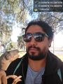
Momentos antes de la tragedia @21.8398,-102.2898
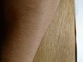
Consecuencias


Achievements
Afiag earned the Land geohash achievement
|
Afiag earned the Graticule Unlocked Achievement
|
Afiag earned the Velociraptor Geohash Achievement
|