Difference between revisions of "2021-02-06 49 8"
| Line 1: | Line 1: | ||
| − | + | {{meetup graticule | |
| − | |||
| − | |||
| − | |||
| − | |||
| − | |||
| − | |||
| − | |||
| − | |||
| lat={{#explode:{{SUBPAGENAME}}| |1}} | | lat={{#explode:{{SUBPAGENAME}}| |1}} | ||
| lon={{#explode:{{SUBPAGENAME}}| |2}} | | lon={{#explode:{{SUBPAGENAME}}| |2}} | ||
| date={{#explode:{{SUBPAGENAME}}| |0}} | | date={{#explode:{{SUBPAGENAME}}| |0}} | ||
| − | }} | + | }} |
__NOTOC__ | __NOTOC__ | ||
== Location == | == Location == | ||
| Line 27: | Line 19: | ||
== Expedition == | == Expedition == | ||
<!-- how it all turned out. your narrative goes here. --> | <!-- how it all turned out. your narrative goes here. --> | ||
| + | will follow soon. | ||
== Tracklog == | == Tracklog == | ||
| Line 33: | Line 26: | ||
== Photos == | == Photos == | ||
<!-- Insert pictures between the gallery tags using the following format: | <!-- Insert pictures between the gallery tags using the following format: | ||
| − | + | ||
| + | |||
--> | --> | ||
<gallery perrow="5"> | <gallery perrow="5"> | ||
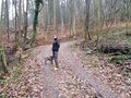
| + | image:2021-02-06_49_8_locationoverview.jpg | overview of the area | ||
| + | image:2021-02-06_49_8_ pond.jpg | overflowing water behind the hashpoint | ||
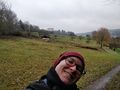
| + | image:2021-02-06_49_8_ viewonlichtenberg.jpg | view on castle Lichtenberg from the hash location | ||
| + | image:2021-02-06_49_8_exposureishard.jpg | correct exposure is hard | ||
| + | image:2021-02-06_49_8_stupidgrin.jpg | StupidGrin^TM | ||
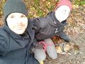
| + | image:2021-02-06_49_8_usandlichtenberg.jpg | Us and Lichtenberg in the background | ||
| + | image:2021-02-06_49_8_waytoohappy.jpg | way to much fun for the drowned rat achievement | ||
| + | image:2021-02-06_49_8_santupedro.jpg | Santu and Pedro at the location | ||
| + | image:2021-02-06_49_8_proof.jpg | proof | ||
</gallery> | </gallery> | ||
Revision as of 17:22, 8 February 2021
| Sat 6 Feb 2021 in 49,8: 49.7667093, 8.8028228 geohashing.info google osm bing/os kml crox |
Location
on a path vith a nice view on the castle Lichtenberg
Participants
- Gefrierbrand
- Santu
- Pedro the dog
- an unknown nice Lady with another dog a few dozen meters ahead of us.
Plans
We noticed that the hashlocation was very near to a trail we had wandered along before near Lichtenberg and decided it was time for a No Batteries Included achievement. We carefully compared different arial pictures and looked for noticeable landmarks to be able to get as close tho the point as possible. We identiefied a few key intersetions and printed the maps. Due to the bad and very rainy weather we had to wrap them in clear plastic sheets.
Expedition
will follow soon.
Tracklog
Photos
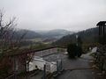
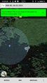
overview of the area
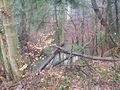
overflowing water behind the hashpoint
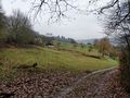
view on castle Lichtenberg from the hash location
correct exposure is hard
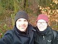
StupidGrin^TM
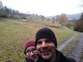
Us and Lichtenberg in the background
way to much fun for the drowned rat achievement
Santu and Pedro at the location
proof


Achievements
Gefrierbrand & Santu earned the Land geohash achievement
|
Gefrierbrand & Santu earned the No Batteries Geohash Achievement
|