Difference between revisions of "2021-02-11 47 -122"
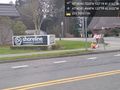
([live picture]Shoreline church [https://openstreetmap.org/?lat=47.76319300&lon=-122.32926450&zoom=16&layers=B000FTF @47.7632,-122.3293]) |
(1st success 2021, 230th success on 297th expedition) |
||
| Line 1: | Line 1: | ||
| − | + | {{meetup graticule | |
| − | |||
| − | |||
| − | |||
| − | |||
| − | |||
| − | |||
| − | |||
| − | |||
| lat=47 | | lat=47 | ||
| lon=-122 | | lon=-122 | ||
| date=2021-02-11 | | date=2021-02-11 | ||
| − | }} | + | | graticule_name=Seattle |
| + | | graticule_link=Seattle, Washington | ||
| + | }} | ||
__NOTOC__ | __NOTOC__ | ||
== Location == | == Location == | ||
| − | + | The middle of 2nd Ave NE in the Meridian Park neighborhood of North Seattle. | |
== Participants == | == Participants == | ||
| − | + | * [[User:Thomcat|Thomcat]] | |
| − | |||
== Plans == | == Plans == | ||
| − | + | Visit on the way back from the library | |
== Expedition == | == Expedition == | ||
| − | + | So originally I planned to visit on the way back from the library - picking up some books for winter weekend hibernation. Yes, we don't get much snow in Seattle, but the danger of a town where absolutely nobody can drive in the snow is not to be underestimated! | |
| + | |||
| + | Distracted, I returned home first, then went back out to visit the hashpoint (with dragalong dog). Right in the middle of the road, I was able to park on the spot. I confirmed that the arrows shown in the streetview (conveniently pointing to the hashpoint) were no longer there, but opted not to recreate them in blue chalk that would be wiped away in a few hours. | ||
| + | |||
| + | Returning home, I saw there were no geohashes in or on Meridian, and none in Shoreline. Will have to write those challenges up soon. | ||
== Tracklog == | == Tracklog == | ||
| Line 45: | Line 42: | ||
<!-- =============== USEFUL CATEGORIES FOLLOW ================ | <!-- =============== USEFUL CATEGORIES FOLLOW ================ | ||
| − | |||
| − | |||
| − | |||
| − | |||
| − | |||
| − | |||
| − | |||
| − | |||
| − | |||
| − | |||
| − | |||
| − | |||
| − | |||
[[Category:Expeditions]] | [[Category:Expeditions]] | ||
| − | |||
[[Category:Expeditions with photos]] | [[Category:Expeditions with photos]] | ||
| − | |||
| − | |||
| − | |||
| − | |||
| − | |||
[[Category:Coordinates reached]] | [[Category:Coordinates reached]] | ||
| − | + | {{location|US|WA|KI}} | |
| − | |||
| − | |||
| − | |||
| − | |||
| − | |||
| − | |||
| − | |||
| − | |||
| − | |||
| − | |||
| − | |||
| − | |||
| − | |||
| − | |||
| − | |||
| − | |||
Revision as of 19:29, 12 February 2021
| Thu 11 Feb 2021 in Seattle: 47.7613204, -122.3282268 geohashing.info google osm bing/os kml crox |
Location
The middle of 2nd Ave NE in the Meridian Park neighborhood of North Seattle.
Participants
Plans
Visit on the way back from the library
Expedition
So originally I planned to visit on the way back from the library - picking up some books for winter weekend hibernation. Yes, we don't get much snow in Seattle, but the danger of a town where absolutely nobody can drive in the snow is not to be underestimated!
Distracted, I returned home first, then went back out to visit the hashpoint (with dragalong dog). Right in the middle of the road, I was able to park on the spot. I confirmed that the arrows shown in the streetview (conveniently pointing to the hashpoint) were no longer there, but opted not to recreate them in blue chalk that would be wiped away in a few hours.
Returning home, I saw there were no geohashes in or on Meridian, and none in Shoreline. Will have to write those challenges up soon.
Tracklog
Photos

Geohasher @47.7613,-122.3282
Shoreline church @47.7632,-122.3293

