Difference between revisions of "2021-02-20 45 4"
(Created page with "{{meetup graticule | lat = 45 | lon = 4 | date = 2021-02-20 }} == Location == On a small mountain above wikipedia:Courzieu. == Participants == * User:Baarde|Baar...") |
m (→Achievements: Update ribbon width) |
||
| (5 intermediate revisions by 2 users not shown) | |||
| Line 14: | Line 14: | ||
== Expedition == | == Expedition == | ||
| + | Courzieu is located in the ''Monts du Lyonnais'', a low-altitude mountain range west of Lyon. After exiting Sain-Bel, I climbed uphill and hiked southwards toward Courzieu. After 11 km I reached two antennas near the summit of a small mountain. There I stopped to eat my lunch (hard-boiled eggs and bananas) and enjoy the view on the Brévenne river valley. | ||
| + | |||
| + | It was a warm and sunny afternoon. I had food and water for myself, a spare battery for my phone, a book to pass the time. I considered waiting there for someone to show up or for the clock to mark 16:00. Unfortunately, there was not a moment to lose, so I packed my stuff and walked to the hashpoint, which was a little bit downhill from the antennas. | ||
| + | |||
| + | After recording proof, I walked back to Sain-Bel, totaling a distance of nearly 24 km. Not bad. | ||
== Photos == | == Photos == | ||
| + | <gallery> | ||
| + | Image:2021-02-20 45 4 01.jpg | In Sain-Bel train station | ||
| + | Image:2021-02-20 45 4 02.jpg | What a lovely day! | ||
| + | Image:2021-02-20 45 4 03.jpg | Near the geohash | ||
| + | Image:2021-02-20 45 4 04.png | Coordinates reached | ||
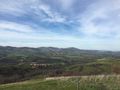
| + | Image:2021-02-20 45 4 05.jpg | Surroundings (north-west) | ||
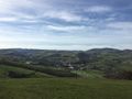
| + | Image:2021-02-20 45 4 06.jpg | Surroundings (south-east) | ||
| + | Image:2021-02-20 45 4 07.jpg | Stupid grin | ||
| + | </gallery> | ||
== Achievements == | == Achievements == | ||
| − | {{#vardefine:ribbonwidth| | + | {{#vardefine:ribbonwidth|100%}} |
| + | |||
| + | {{land geohash | ||
| + | | latitude = 45 | ||
| + | | longitude = 4 | ||
| + | | date = 2021-02-20 | ||
| + | | name = [[User:Baarde|Baarde]] | ||
| + | }} | ||
| + | {{consecutive geohash 2 | ||
| + | | latitude = 45 | ||
| + | | longitude = 5 | ||
| + | | date = 2021-02-19 | ||
| + | | name = [[User:Baarde|Baarde]] | ||
| + | | count = 2 | ||
| + | }} | ||
__NOTOC__ | __NOTOC__ | ||
[[Category:Expeditions]] | [[Category:Expeditions]] | ||
| + | [[Category:Expeditions with photos]] | ||
| + | [[Category:Coordinates reached]] | ||
| + | {{location|FR|69}} | ||
Latest revision as of 15:43, 4 May 2021
| Sat 20 Feb 2021 in 45,4: 45.7522989, 4.5655085 geohashing.info google osm bing/os kml crox |
Location
On a small mountain above Courzieu.
Participants
Plans
Baarde has taken the 11:45 train from Lyon to Sain-Bel and will hike the remaining 8 km to the geohash. He expects to be there at 14:30.
Expedition
Courzieu is located in the Monts du Lyonnais, a low-altitude mountain range west of Lyon. After exiting Sain-Bel, I climbed uphill and hiked southwards toward Courzieu. After 11 km I reached two antennas near the summit of a small mountain. There I stopped to eat my lunch (hard-boiled eggs and bananas) and enjoy the view on the Brévenne river valley.
It was a warm and sunny afternoon. I had food and water for myself, a spare battery for my phone, a book to pass the time. I considered waiting there for someone to show up or for the clock to mark 16:00. Unfortunately, there was not a moment to lose, so I packed my stuff and walked to the hashpoint, which was a little bit downhill from the antennas.
After recording proof, I walked back to Sain-Bel, totaling a distance of nearly 24 km. Not bad.
Photos
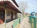
In Sain-Bel train station
What a lovely day!
Near the geohash
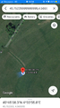
Coordinates reached
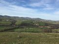
Surroundings (north-west)
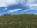
Surroundings (south-east)
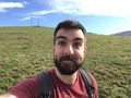
Stupid grin


Achievements
Baarde earned the Land geohash achievement
|
Baarde earned the Consecutive geohash achievement
|