Difference between revisions of "2021-02-23 46 4"
From Geohashing
(Coordinates reached and photos) |
m (→Achievements: Update ribbon width) |
||
| (One intermediate revision by the same user not shown) | |||
| Line 21: | Line 21: | ||
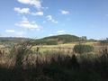
Image:2021-02-23 46 4 02.jpg | Leaving the Botoret valley | Image:2021-02-23 46 4 02.jpg | Leaving the Botoret valley | ||
Image:2021-02-23 46 4 03.jpg | A very nice footpath | Image:2021-02-23 46 4 03.jpg | A very nice footpath | ||
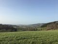
| − | Image:2021-02-23 46 4 05.jpg | The | + | Image:2021-02-23 46 4 05.jpg | The geohash |
Image:2021-02-23 46 4 06.png | Coordinates reached | Image:2021-02-23 46 4 06.png | Coordinates reached | ||
Image:2021-02-23 46 4 07.jpg | Stupid grin | Image:2021-02-23 46 4 07.jpg | Stupid grin | ||
| Line 29: | Line 29: | ||
== Achievements == | == Achievements == | ||
| − | {{#vardefine:ribbonwidth| | + | {{#vardefine:ribbonwidth|100%}} |
{{land geohash | {{land geohash | ||
| latitude = 46 | | latitude = 46 | ||
Latest revision as of 15:44, 4 May 2021
| Tue 23 Feb 2021 in 46,4: 46.1718721, 4.3866675 geohashing.info google osm bing/os kml crox |
Location
In a young pine trees plantation near Belleroche.
Participants
Plans
Today looks like a nice day for hiking. I’ll take the train then walk the path from Chauffailles to Belleroche. I should reach the coordinates around 14:20.
Expedition
Coming soon
Photos

At Chauffailles train station
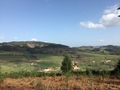
Leaving the Botoret valley
A very nice footpath
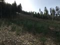
The geohash
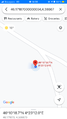
Coordinates reached

Stupid grin
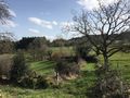
Surroundings
Going back to Chauffailles


Achievements
Baarde earned the Land geohash achievement
|