Difference between revisions of "2021-02-27 45 4"
From Geohashing
m (→Location: Fix link format) |
(Coordinates reached) |
||
| Line 13: | Line 13: | ||
== Plans == | == Plans == | ||
I plan to hike through the Pilat mountains, from Rive-de-Gier to Condrieu. The hashpoint is somewhere on the middle and I should be there around 14:00. | I plan to hike through the Pilat mountains, from Rive-de-Gier to Condrieu. The hashpoint is somewhere on the middle and I should be there around 14:00. | ||
| + | |||
| + | == Expedition == | ||
| + | Coming soon. | ||
| + | |||
| + | == Photos == | ||
| + | <gallery> | ||
| + | Image:2021-02-27 45 4 01.jpg | Leaving Rive-de-Gier | ||
| + | Image:2021-02-27 45 4 02.jpg | The pinnacle of this expedition | ||
| + | Image:2021-02-27 45 4 03.jpg | The geohash | ||
| + | Image:2021-02-27 45 4 04.png | Coordinates reached | ||
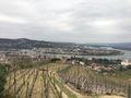
| + | Image:2021-02-27 45 4 05.jpg | Surroundings (north-west) | ||
| + | Image:2021-02-27 45 4 06.jpg | Surroundings (north-east) | ||
| + | Image:2021-02-27 45 4 07.jpg | Stupid grin | ||
| + | Image:2021-02-27 45 4 08.jpg | Leaving the Pilat mountains… | ||
| + | Image:2021-02-27 45 4 09.jpg | and entering the Rhône valley | ||
| + | Image:2021-02-27 45 4 10.jpg | Arriving at Condrieu | ||
| + | </gallery> | ||
| + | |||
| + | == Achievements == | ||
| + | {{#vardefine:ribbonwidth|800px}} | ||
| + | {{land geohash | ||
| + | | latitude = 45 | ||
| + | | longitude = 4 | ||
| + | | date = 2021-02-27 | ||
| + | | name = [[User:Baarde|Baarde]] | ||
| + | }} | ||
__NOTOC__ | __NOTOC__ | ||
[[Category:Expeditions]] | [[Category:Expeditions]] | ||
| + | [[Category:Expeditions with photos]] | ||
| + | [[Category:Coordinates reached]] | ||
{{location|FR|42}} | {{location|FR|42}} | ||
Revision as of 18:20, 1 March 2021
| Sat 27 Feb 2021 in 45,4: 45.4750496, 4.6846505 geohashing.info google osm bing/os kml crox |
Location
In a meadow, near a mountain pass in La Chapelle-Villars.
Participants
Plans
I plan to hike through the Pilat mountains, from Rive-de-Gier to Condrieu. The hashpoint is somewhere on the middle and I should be there around 14:00.
Expedition
Coming soon.
Photos
Leaving Rive-de-Gier
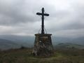
The pinnacle of this expedition
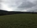
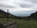
The geohash
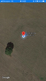
Coordinates reached
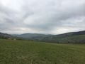
Surroundings (north-west)
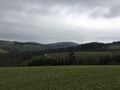
Surroundings (north-east)
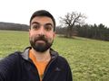
Stupid grin

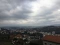
Leaving the Pilat mountains…
and entering the Rhône valley
Arriving at Condrieu


Achievements
Baarde earned the Land geohash achievement
|