Difference between revisions of "2021-03-17 48 11"
From Geohashing
Rkschlotte (talk | contribs) (→Photos) |
Rkschlotte (talk | contribs) (→Achievements) |
||
| Line 56: | Line 56: | ||
<!-- If all those plans are never acted upon, change [[Category:Expedition planning]] to [[Category:Not reached - Did not attempt]]. --> | <!-- If all those plans are never acted upon, change [[Category:Expedition planning]] to [[Category:Not reached - Did not attempt]]. --> | ||
| − | |||
[[Category:Expeditions]] | [[Category:Expeditions]] | ||
| − | |||
[[Category:Expeditions with photos]] | [[Category:Expeditions with photos]] | ||
| − | |||
| − | |||
| − | |||
| − | |||
| − | |||
[[Category:Coordinates reached]] | [[Category:Coordinates reached]] | ||
| − | |||
| − | |||
| − | |||
| − | |||
| − | |||
| − | |||
| − | |||
| − | |||
| − | |||
| − | |||
| − | |||
| − | |||
| − | |||
| − | |||
| − | |||
| − | |||
| − | |||
| − | |||
Revision as of 21:00, 17 April 2021
| Wed 17 Mar 2021 in 48,11: 48.6986155, 11.3156026 geohashing.info google osm bing/os kml crox |
Location
Right beside the street from Weichering to Neuschwetzingen.
Participants
Plans
Expedition
Tracklog
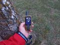
Photos
Witty Comment
