Difference between revisions of "2021-04-02 52 4"
FelixTheCat (talk | contribs) (Created page with "{{subst:Expedition |lat = 52 |lon = 4 |date = 2021-04-02 }}") |
FelixTheCat (talk | contribs) |
||
| Line 1: | Line 1: | ||
| − | + | {{meetup graticule | |
| − | |||
| − | |||
| − | |||
| − | |||
| − | |||
| − | |||
| − | |||
| − | |||
| lat=52 | | lat=52 | ||
| lon=4 | | lon=4 | ||
| date=2021-04-02 | | date=2021-04-02 | ||
| − | }} | + | }} |
| − | |||
== Location == | == Location == | ||
| − | + | Voorschoterweg, Leiden, South Holland province. | |
== Participants == | == Participants == | ||
| − | + | [[User:FelixTheCat|FelixTheCat]] ([[User talk:FelixTheCat|talk]]) | |
| − | |||
| − | |||
| − | |||
| − | |||
== Expedition == | == Expedition == | ||
| − | + | Today's hash was on the edge of a road at the southern end of Leiden. I actually had time to go there during the daytime, because my new employer considers Good Friday to be a holiday (it is not a national holiday; while schools and government offices are closed, the private sector generally keeps working). The exact location looked slightly tricky, right on the edge of a busy road. Nevertheless I got on my bike and rode through Delft, Rijswijk, Voorburg, Leidschendam and Voorschoten to reach the Voorschoterweg in Leiden. Because the road was rather busy (as it usually is), my strategy was to stand on the bike path and wait for a lull in traffic, then quickly scoot forward to grab the hash point and retreat to safety. This worked surprisingly well, and I managed to reach the point. Then I rode home again. | |
| − | |||
| − | |||
| − | |||
== Photos == | == Photos == | ||
| − | |||
| − | |||
| − | |||
<gallery perrow="5"> | <gallery perrow="5"> | ||
| + | Image:2021-04-02 52 4 FelixTheCat 1.JPG | The hash is right ahead, just on the edge of the carriageway. | ||
| + | Image:2021-04-02 52 4 FelixTheCat 2.JPG | Looking south, towards Voorschoten. | ||
| + | Image:2021-04-02 52 4 FelixTheCat 3.JPG | Looking north, towards Leiden. Waiting for traffic to calm down for a second. | ||
| + | Image:2021-04-02 52 4 FelixTheCat 4.jpg | After quickly stepping forward, we reach the hash! | ||
| + | Image:2021-04-02 52 4 FelixTheCat 5.JPG | Lloyd celebrating. | ||
</gallery> | </gallery> | ||
== Achievements == | == Achievements == | ||
{{#vardefine:ribbonwidth|800px}} | {{#vardefine:ribbonwidth|800px}} | ||
| − | + | {{bicycle geohash | |
| − | + | | latitude = 52 | |
| − | + | | longitude = 4 | |
| − | + | | date = 2021-04-02 | |
| − | [[ | + | | name = [[User:FelixTheCat|FelixTheCat]] ([[User talk:FelixTheCat|talk]]) |
| − | + | | distance = 38.8 km | |
| − | + | | bothways = true | |
| − | + | }} | |
| − | |||
| − | |||
| − | [[ | ||
| − | |||
| − | |||
| − | |||
| − | |||
| − | |||
[[Category:Expeditions]] | [[Category:Expeditions]] | ||
| − | |||
[[Category:Expeditions with photos]] | [[Category:Expeditions with photos]] | ||
| − | |||
| − | |||
| − | |||
| − | |||
| − | |||
[[Category:Coordinates reached]] | [[Category:Coordinates reached]] | ||
| − | |||
| − | |||
| − | |||
| − | |||
| − | |||
| − | |||
| − | |||
| − | |||
| − | |||
| − | |||
| − | |||
| − | |||
| − | |||
| − | |||
| − | |||
| − | |||
| − | |||
| − | |||
Revision as of 16:54, 2 April 2021
| Fri 2 Apr 2021 in 52,4: 52.1377595, 4.4736326 geohashing.info google osm bing/os kml crox |
Location
Voorschoterweg, Leiden, South Holland province.
Participants
Expedition
Today's hash was on the edge of a road at the southern end of Leiden. I actually had time to go there during the daytime, because my new employer considers Good Friday to be a holiday (it is not a national holiday; while schools and government offices are closed, the private sector generally keeps working). The exact location looked slightly tricky, right on the edge of a busy road. Nevertheless I got on my bike and rode through Delft, Rijswijk, Voorburg, Leidschendam and Voorschoten to reach the Voorschoterweg in Leiden. Because the road was rather busy (as it usually is), my strategy was to stand on the bike path and wait for a lull in traffic, then quickly scoot forward to grab the hash point and retreat to safety. This worked surprisingly well, and I managed to reach the point. Then I rode home again.
Photos
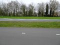
The hash is right ahead, just on the edge of the carriageway.
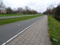
Looking south, towards Voorschoten.
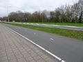
Looking north, towards Leiden. Waiting for traffic to calm down for a second.
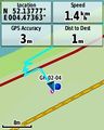
After quickly stepping forward, we reach the hash!
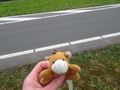
Lloyd celebrating.


Achievements
FelixTheCat (talk) earned the Bicycle geohash achievement
|