Difference between revisions of "2021-04-11 52 4"
FelixTheCat (talk | contribs) (Created page with "{{subst:Expedition |lat = 52 |lon = 4 |date = 2021-04-11 }}") |
FelixTheCat (talk | contribs) |
||
| Line 1: | Line 1: | ||
| − | + | {{meetup graticule | |
| − | |||
| − | |||
| − | |||
| − | |||
| − | |||
| − | |||
| − | |||
| − | |||
| lat=52 | | lat=52 | ||
| lon=4 | | lon=4 | ||
| Line 14: | Line 6: | ||
__NOTOC__ | __NOTOC__ | ||
== Location == | == Location == | ||
| − | + | On the beach outside Bergen aan Zee, North Holland province. | |
== Participants == | == Participants == | ||
| − | + | * [[User:FelixTheCat|FelixTheCat]] ([[User talk:FelixTheCat|talk]]) | |
| − | + | * Kat the Awesome | |
| − | |||
| − | |||
| − | |||
== Expedition == | == Expedition == | ||
| − | + | Today's hash was on the beach somewhat to the north of Bergen aan Zee. The point appeared to be right on the edge of the beach at low tide, so I checked the tide calendar and found out we should be there at around 12:30. Kat was enthusiastic about taking a long walk on the beach, so we drove to Bergen together. Luckily it was rather cold and cloudy, so the roads towards the coast were not busy. After parking the hashmobile we began to walk. The hash point was about two kilometres away, but it took quite a bit of effort due to a strong headwind. When we got near the point it turned out to be within reach of the waves, and therefore tricky to reach without getting my feet wet. It took several tries of waiting for the water to retreat, running forward towards the point, then running back to safety, before I managed to score zero distance on my GPS. | |
| − | + | We then walked around a bit further and finally went back to Bergen on a path through the dunes. We had a small snack in the village (chips and a ''kroket'') before driving home again. | |
| − | |||
== Photos == | == Photos == | ||
| − | |||
| − | |||
| − | |||
<gallery perrow="5"> | <gallery perrow="5"> | ||
| + | Image:2021-04-11 52 4 FelixTheCat 1.JPG | We've arrived in Bergen aan Zee. On a warmer Sunday this car park would have been overflowing on all sides. | ||
| + | Image:2021-04-11 52 4 FelixTheCat 2.JPG | It's nice and quiet on the beach too. | ||
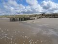
| + | Image:2021-04-11 52 4 FelixTheCat 3.JPG | The hash is up ahead near those poles. | ||
| + | Image:2021-04-11 52 4 FelixTheCat 4.JPG | Somewhere here, that is. It's a bit too cold to just take off my shoes and wade in. | ||
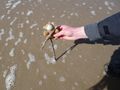
| + | Image:2021-04-11 52 4 FelixTheCat 5.JPG | After several attempts I managed to push this stick into the ground at the right point. | ||
| + | Image:2021-04-11 52 4 FelixTheCat 6.png | GPS proof. | ||
| + | Image:2021-04-11 52 4 FelixTheCat 7.JPG | Lloyd celebrating. | ||
| + | Image:2021-04-11 52 4 FelixTheCat 8.JPG | Looking back towards the dunes. | ||
| + | Image:2021-04-11 52 4 FelixTheCat 9.JPG | After climbing one of them we're greeted by this beautiful landscape. | ||
</gallery> | </gallery> | ||
== Achievements == | == Achievements == | ||
{{#vardefine:ribbonwidth|800px}} | {{#vardefine:ribbonwidth|800px}} | ||
| − | + | {{land geohash | |
| − | + | | latitude = 52 | |
| − | + | | longitude = 4 | |
| − | + | | date = 2021-04-11 | |
| − | + | | name = [[User:FelixTheCat|FelixTheCat]] ([[User talk:FelixTheCat|talk]]) and Kat | |
| − | + | }} | |
| − | |||
| − | |||
| − | |||
| − | |||
| − | [[ | ||
| − | |||
| − | |||
| − | |||
| − | |||
| − | |||
[[Category:Expeditions]] | [[Category:Expeditions]] | ||
| − | |||
[[Category:Expeditions with photos]] | [[Category:Expeditions with photos]] | ||
| − | |||
| − | |||
| − | |||
| − | |||
| − | |||
[[Category:Coordinates reached]] | [[Category:Coordinates reached]] | ||
| − | |||
| − | |||
| − | |||
| − | |||
| − | |||
| − | |||
| − | |||
| − | |||
| − | |||
| − | |||
| − | |||
| − | |||
| − | |||
| − | |||
| − | |||
| − | |||
| − | |||
| − | |||
Revision as of 14:30, 11 April 2021
| Sun 11 Apr 2021 in 52,4: 52.6865853, 4.6324570 geohashing.info google osm bing/os kml crox |
Location
On the beach outside Bergen aan Zee, North Holland province.
Participants
- FelixTheCat (talk)
- Kat the Awesome
Expedition
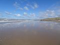
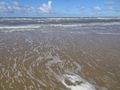
Today's hash was on the beach somewhat to the north of Bergen aan Zee. The point appeared to be right on the edge of the beach at low tide, so I checked the tide calendar and found out we should be there at around 12:30. Kat was enthusiastic about taking a long walk on the beach, so we drove to Bergen together. Luckily it was rather cold and cloudy, so the roads towards the coast were not busy. After parking the hashmobile we began to walk. The hash point was about two kilometres away, but it took quite a bit of effort due to a strong headwind. When we got near the point it turned out to be within reach of the waves, and therefore tricky to reach without getting my feet wet. It took several tries of waiting for the water to retreat, running forward towards the point, then running back to safety, before I managed to score zero distance on my GPS.
We then walked around a bit further and finally went back to Bergen on a path through the dunes. We had a small snack in the village (chips and a kroket) before driving home again.
Photos
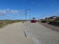
We've arrived in Bergen aan Zee. On a warmer Sunday this car park would have been overflowing on all sides.
It's nice and quiet on the beach too.
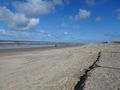
The hash is up ahead near those poles.
Somewhere here, that is. It's a bit too cold to just take off my shoes and wade in.

After several attempts I managed to push this stick into the ground at the right point.
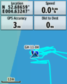
GPS proof.
Lloyd celebrating.
Looking back towards the dunes.

After climbing one of them we're greeted by this beautiful landscape.


Achievements
FelixTheCat (talk) and Kat earned the Land geohash achievement
|