Difference between revisions of "2021-04-22 50 8"
(Created page with "{{subst:Expedition |lat = 50 |lon = 8 |date = 2021-04-22 }}") |
|||
| Line 1: | Line 1: | ||
| − | + | {{meetup graticule | |
| − | |||
| − | |||
| − | |||
| − | |||
| − | |||
| − | |||
| − | |||
| − | |||
| lat=50 | | lat=50 | ||
| lon=8 | | lon=8 | ||
| Line 14: | Line 6: | ||
__NOTOC__ | __NOTOC__ | ||
== Location == | == Location == | ||
| − | + | In the woods near Hundstadt. | |
== Participants == | == Participants == | ||
| − | + | * [[User:Mampfred|Mampfred]] | |
| − | + | * [[User:LadyBB|LadyBB]] | |
| + | * [[User::EmmJay|EmmJay]] | ||
== Plans == | == Plans == | ||
| − | + | We're on our way to Wetzlar on thursday and conveniently the hash is pretty much in the middle of our way (although we would've taken the Autobahn if it weren't for the hash). | |
== Expedition == | == Expedition == | ||
| − | + | We got to Wilhelmsdorf around 11am and started walking up the little hill enjoying the amazing weather on this fine morning. | |
| − | + | On top we found a heavily fenced area apparantly belonging to the "Bundespolizeiversorgungslager" Hundstadt and the hash would not be far from their perimeter. The heavy fencing worried us some, would they also have survailance around the perimeter and notice us sneaking into the woods? | |
| − | + | ||
| + | We eventually took a beeline into the woods for about 50 meters and easily found the hash and toook some photos. Nobody noticed or bothered so all is well :) | ||
== Photos == | == Photos == | ||
| − | |||
| − | |||
| − | |||
<gallery perrow="5"> | <gallery perrow="5"> | ||
| + | Image:2021-04-22_50_8_fencing.jpg | Heavy fencing next to the path | ||
| + | Image:2021-04-22_50_8_coordinates_reached.png | Coordinates reached | ||
| + | Image:2021-04-22_50_8_the_hash.jpg | A look at the hash | ||
| + | Image:2021-04-22_50_8_stupid_grin.jpg | Stupid group grin | ||
</gallery> | </gallery> | ||
== Achievements == | == Achievements == | ||
| − | |||
| − | |||
| − | |||
| − | |||
| − | |||
| − | |||
| − | |||
| − | |||
| − | |||
| − | |||
| − | |||
| − | |||
| − | |||
| − | |||
| − | |||
| − | |||
| − | |||
[[Category:Expeditions]] | [[Category:Expeditions]] | ||
| − | |||
[[Category:Expeditions with photos]] | [[Category:Expeditions with photos]] | ||
| − | |||
| − | |||
| − | |||
| − | |||
| − | |||
[[Category:Coordinates reached]] | [[Category:Coordinates reached]] | ||
| − | |||
| − | |||
| − | |||
| − | |||
| − | |||
| − | |||
| − | |||
| − | |||
| − | |||
| − | |||
| − | |||
| − | |||
| − | |||
| − | |||
| − | |||
| − | |||
| − | |||
| − | |||
Revision as of 08:12, 23 April 2021
| Thu 22 Apr 2021 in 50,8: 50.3561321, 8.4882820 geohashing.info google osm bing/os kml crox |
Location
In the woods near Hundstadt.
Participants
Plans
We're on our way to Wetzlar on thursday and conveniently the hash is pretty much in the middle of our way (although we would've taken the Autobahn if it weren't for the hash).
Expedition
We got to Wilhelmsdorf around 11am and started walking up the little hill enjoying the amazing weather on this fine morning.
On top we found a heavily fenced area apparantly belonging to the "Bundespolizeiversorgungslager" Hundstadt and the hash would not be far from their perimeter. The heavy fencing worried us some, would they also have survailance around the perimeter and notice us sneaking into the woods?
We eventually took a beeline into the woods for about 50 meters and easily found the hash and toook some photos. Nobody noticed or bothered so all is well :)
Photos
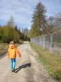
Heavy fencing next to the path
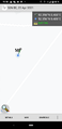
Coordinates reached
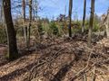
A look at the hash

Stupid group grin


