Difference between revisions of "2021-04-25 50 7"
From Geohashing
Gefrierbrand (talk | contribs) (Created page with "{{subst:Expedition}}") |
Gefrierbrand (talk | contribs) |
||
| (10 intermediate revisions by 2 users not shown) | |||
| Line 1: | Line 1: | ||
| − | + | {{meetup graticule | |
| − | |||
| − | |||
| − | |||
| − | |||
| − | |||
| − | |||
| − | |||
| − | |||
| lat={{#explode:{{SUBPAGENAME}}| |1}} | | lat={{#explode:{{SUBPAGENAME}}| |1}} | ||
| lon={{#explode:{{SUBPAGENAME}}| |2}} | | lon={{#explode:{{SUBPAGENAME}}| |2}} | ||
| date={{#explode:{{SUBPAGENAME}}| |0}} | | date={{#explode:{{SUBPAGENAME}}| |0}} | ||
| − | }} | + | }} |
__NOTOC__ | __NOTOC__ | ||
== Location == | == Location == | ||
| − | + | in a forest near Andernach | |
== Participants == | == Participants == | ||
| − | + | *[[User:Santu|Santu]] | |
| − | + | *[[User:Gefrierbrand|Gefrierbrand]] | |
| + | *Pedro the dog | ||
== Plans == | == Plans == | ||
| − | + | Drive to Eich, walk to the hash from there and explore the area. | |
== Expedition == | == Expedition == | ||
| − | + | * saw an incredibly musculus grey bull and three calves | |
| − | + | * found hashlocation after short search on steep forest ground | |
| − | + | * ate boiled eggs and sweets | |
| − | + | * explored general area | |
| + | * drove a few km to "[https://www.traumpfade.info/pfad/traumpfad/hoehlen-und-schluchtensteig/?lang=en Traumpfad]" (dream path) | ||
| + | * walked along it until wolf canyon | ||
| + | * seen old mineshaft, roman well and the radome of [https://en.wikipedia.org/wiki/TIRA TIRA] in the distance | ||
== Photos == | == Photos == | ||
| Line 34: | Line 30: | ||
--> | --> | ||
<gallery perrow="5"> | <gallery perrow="5"> | ||
| + | File:2021-04-24 50 7 bull.jpg | muscular bull on the way to the hash | ||
| + | File:2021-04-24 50 7 santusearching.jpg | Santu and pedro travelling through the forrest | ||
| + | File:2021-04-24 50 7 gefrierbrand searching.jpg | Gefrierbrand searching for GPS signals near the hash | ||
| + | File:2021-04-24 50 7 proof.jpg | coordinates reached! | ||
| + | File:2021-04-24 50 7 stupidgrin.jpg | Stupid grin<sup>TM</sup> | ||
| + | File:2021-04-24 50 7 pedrogrin.jpg | Pedro wants to be included | ||
| + | File:2021-04-24 50 7 throne.jpg | We found a nice throne-like stump | ||
| + | File:2021-04-24 50 7 binoculars radome.jpg | Radome of TIRA through Binoculars | ||
| + | File:2021-04-24 50 7 wolf canyon.jpg | Wolf Canyon waterfall | ||
| + | File:2021-04-24 50 7 wolf canyon smile.jpg | second stupid grin<sup>TM</sup> in canyon | ||
| + | File:2021-04-24 50 7 old mineshaft.jpg | old mineshaft | ||
| + | File:2021-04-24_50_7 bull painting.jpg| Santus Painting | ||
</gallery> | </gallery> | ||
== Achievements == | == Achievements == | ||
{{#vardefine:ribbonwidth|800px}} | {{#vardefine:ribbonwidth|800px}} | ||
| − | + | {{land geohash | |
| − | + | | latitude = {{#explode:{{SUBPAGENAME}}| |1}} | |
| − | + | | longitude = {{#explode:{{SUBPAGENAME}}| |2}} | |
| − | + | | date = {{#explode:{{SUBPAGENAME}}| |0}} | |
| − | + | | name = Santu & Gefrierbrand | |
| − | + | }} | |
| − | + | {{Geobrush | |
| − | + | | latitude = {{#explode:{{SUBPAGENAME}}| |1}} | |
| − | + | | longitude = {{#explode:{{SUBPAGENAME}}| |2}} | |
| − | + | | date = {{#explode:{{SUBPAGENAME}}| |0}} | |
| − | + | | name = Santu | |
| − | + | | form = painting | |
| − | + | | image = 2021-04-24_50_7 bull painting.jpg | |
| − | + | }} | |
| − | |||
| − | |||
[[Category:Expeditions]] | [[Category:Expeditions]] | ||
| − | |||
[[Category:Expeditions with photos]] | [[Category:Expeditions with photos]] | ||
| − | |||
| − | |||
| − | |||
| − | |||
| − | |||
[[Category:Coordinates reached]] | [[Category:Coordinates reached]] | ||
| − | + | [[Category:Expeditions with dogs]] | |
| − | + | {{location|DE|RP|MYK}} | |
| − | |||
| − | |||
| − | |||
| − | |||
| − | |||
| − | |||
| − | |||
| − | |||
| − | |||
| − | |||
| − | [[Category: | ||
| − | |||
| − | |||
| − | |||
| − | |||
| − | |||
Latest revision as of 07:54, 18 October 2022
| Sun 25 Apr 2021 in 50,7: 50.4433877, 7.3591288 geohashing.info google osm bing/os kml crox |
Location
in a forest near Andernach
Participants
- Santu
- Gefrierbrand
- Pedro the dog
Plans
Drive to Eich, walk to the hash from there and explore the area.
Expedition
- saw an incredibly musculus grey bull and three calves
- found hashlocation after short search on steep forest ground
- ate boiled eggs and sweets
- explored general area
- drove a few km to "Traumpfad" (dream path)
- walked along it until wolf canyon
- seen old mineshaft, roman well and the radome of TIRA in the distance
Photos
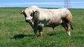
muscular bull on the way to the hash
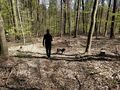
Santu and pedro travelling through the forrest
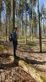
Gefrierbrand searching for GPS signals near the hash
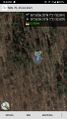
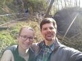
coordinates reached!

Stupid grinTM
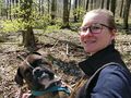
Pedro wants to be included

We found a nice throne-like stump
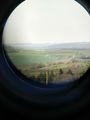
Radome of TIRA through Binoculars
Wolf Canyon waterfall
second stupid grinTM in canyon
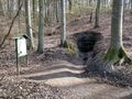
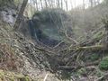
old mineshaft

Santus Painting


Achievements
Santu & Gefrierbrand earned the Land geohash achievement
|
Santu earned the Geobrush achievement
|