Difference between revisions of "2021-04-25 51 4"
FelixTheCat (talk | contribs) (Created page with "{{subst:Expedition |lat = 51 |lon = 4 |date = 2021-04-25 }}") |
FelixTheCat (talk | contribs) |
||
| Line 1: | Line 1: | ||
| − | + | {{meetup graticule | |
| − | |||
| − | |||
| − | |||
| − | |||
| − | |||
| − | |||
| − | |||
| − | |||
| lat=51 | | lat=51 | ||
| lon=4 | | lon=4 | ||
| date=2021-04-25 | | date=2021-04-25 | ||
| − | }} | + | }} |
__NOTOC__ | __NOTOC__ | ||
== Location == | == Location == | ||
| − | + | In a forest outside Huijbergen, North Brabant province. | |
== Participants == | == Participants == | ||
| − | + | [[User:FelixTheCat|FelixTheCat]] ([[User talk:FelixTheCat|talk]]) | |
| − | |||
| − | |||
| − | |||
| − | |||
== Expedition == | == Expedition == | ||
| − | + | Today's hash was in a forest next to Woensdrecht Air Base. I drove the hashmobile to the village of Huijbergen. There are a few pretty buildings, like the village church and a windmill. I walked about 1.8 km to the north, into the forest to find the hash. It was located about 20 m off the footpath, but luckily the forest wasn't too dense and I could reach the point without much difficulty. I took a few pictures and explored the forest a bit more. Then I drove back, did some shopping and went home. | |
| − | |||
| − | |||
| − | |||
== Photos == | == Photos == | ||
| − | |||
| − | |||
| − | |||
<gallery perrow="5"> | <gallery perrow="5"> | ||
| + | Image:2021-04-25 51 4 FelixTheCat 1.JPG | The church of Huijbergen (built 1952) | ||
| + | Image:2021-04-25 51 4 FelixTheCat 2.JPG | The road leading into the forest. | ||
| + | Image:2021-04-25 51 4 FelixTheCat 3.JPG | This forest is a water catchment area, managed by the local water utility. | ||
| + | Image:2021-04-25 51 4 FelixTheCat 4.JPG | There are several pieces of exercise equipment in the forest. | ||
| + | Image:2021-04-25 51 4 FelixTheCat 5.JPG | The hash is here, just outside the footpath. | ||
| + | Image:2021-04-25 51 4 FelixTheCat 6.png | GPS proof. | ||
| + | Image:2021-04-25 51 4 FelixTheCat 7.JPG | Lloyd and Harriet celebrating. | ||
| + | Image:2021-04-25 51 4 FelixTheCat 8.JPG | They have rather large pine cones here. | ||
| + | Image:2021-04-25 51 4 FelixTheCat 9.JPG | Looking out over the fields of western Brabant. | ||
</gallery> | </gallery> | ||
== Achievements == | == Achievements == | ||
{{#vardefine:ribbonwidth|800px}} | {{#vardefine:ribbonwidth|800px}} | ||
| − | + | {{land geohash | |
| − | + | | latitude = 51 | |
| − | + | | longitude = 4 | |
| − | + | | date = 2021-04-25 | |
| − | + | | name = [[User:FelixTheCat|FelixTheCat]] ([[User talk:FelixTheCat|talk]]) | |
| − | + | }} | |
| − | |||
| − | |||
| − | |||
| − | |||
| − | |||
| − | |||
| − | |||
| − | |||
| − | |||
| − | |||
[[Category:Expeditions]] | [[Category:Expeditions]] | ||
| − | |||
[[Category:Expeditions with photos]] | [[Category:Expeditions with photos]] | ||
| − | |||
| − | |||
| − | |||
| − | |||
| − | |||
[[Category:Coordinates reached]] | [[Category:Coordinates reached]] | ||
| − | |||
| − | |||
| − | |||
| − | |||
| − | |||
| − | |||
| − | |||
| − | |||
| − | |||
| − | |||
| − | |||
| − | |||
| − | |||
| − | |||
| − | |||
| − | |||
| − | |||
| − | |||
Revision as of 07:24, 27 April 2021
| Sun 25 Apr 2021 in 51,4: 51.4433877, 4.3591288 geohashing.info google osm bing/os kml crox |
Location
In a forest outside Huijbergen, North Brabant province.
Participants
Expedition
Today's hash was in a forest next to Woensdrecht Air Base. I drove the hashmobile to the village of Huijbergen. There are a few pretty buildings, like the village church and a windmill. I walked about 1.8 km to the north, into the forest to find the hash. It was located about 20 m off the footpath, but luckily the forest wasn't too dense and I could reach the point without much difficulty. I took a few pictures and explored the forest a bit more. Then I drove back, did some shopping and went home.
Photos
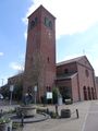
The church of Huijbergen (built 1952)
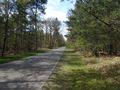
The road leading into the forest.
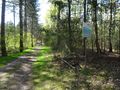
This forest is a water catchment area, managed by the local water utility.
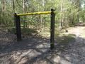
There are several pieces of exercise equipment in the forest.
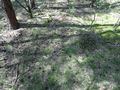
The hash is here, just outside the footpath.
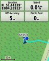
GPS proof.
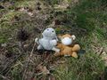
Lloyd and Harriet celebrating.
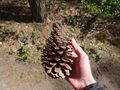
They have rather large pine cones here.
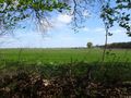
Looking out over the fields of western Brabant.


Achievements
FelixTheCat (talk) earned the Land geohash achievement
|