Difference between revisions of "2021-05-22 39 -4"
m (Categories) |
|||
| Line 52: | Line 52: | ||
{{#vardefine:ribbonwidth|800px}} | {{#vardefine:ribbonwidth|800px}} | ||
<!-- Add any achievement ribbons you earned below, or remove this section --> | <!-- Add any achievement ribbons you earned below, or remove this section --> | ||
| − | |||
| − | |||
| − | |||
| − | |||
| − | |||
| − | |||
| − | |||
| − | |||
| − | |||
| − | |||
| − | |||
| − | |||
| − | |||
[[Category:Expeditions]] | [[Category:Expeditions]] | ||
[[Category:Expeditions with photos]] | [[Category:Expeditions with photos]] | ||
| − | |||
| − | |||
| − | |||
| − | |||
| − | |||
| − | |||
| − | |||
| − | |||
| − | |||
| − | |||
[[Category:Coordinates not reached]] | [[Category:Coordinates not reached]] | ||
| − | [[Category:Not reached - Time constraints]] | + | [[Category:Not reached - Time constraints]] |
| − | |||
| − | |||
| − | |||
| − | |||
| − | |||
| − | |||
| − | |||
| − | |||
| − | |||
| − | |||
| − | |||
| − | |||
| − | |||
| − | |||
Revision as of 08:51, 31 May 2021
| Sat 22 May 2021 in 39,-4: 39.9459240, -4.0762402 geohashing.info google osm bing/os kml crox |
Location
In a hilly mixture of acres and wilderness near Bargas
Participants
Plans
Expedition
My first geohash… attempt — failed.
On the map it had looked like I could get pretty close to the geohash on the road, albeit unpaved the last few kilometers. When I got to the unpaved part after a nice one hour ride over small country roads with few traffic, it turned out that the conditions might have been fine for a handy motocross machine, but not for a 400 kg Goldwing. Moreover, the path got narrow and showed pronounced ruts, so that I could not have turned around. Should one go on under such conditions? Of course not, stupid!
In retrospective, I suspect that I had a serious attack of get-there-itis, a well known phenomenon among pilots. I stubbornly rode on, and it got really bad. After about a kilometer, I reached a crossroad embedded in a flat, level area where I could turn around and park the bike, soaked in fear sweat.
The GPS showed the geohash still three kilometers away. I took a foot path leading roughly in the right direction, but after about 100 meters, it turned and I would have had to walk cross country. The terrain was a mixture of acres and wilderness, and if I avoided the acres, it would have taken quite some time, more than I had planned to spend, to reach the geohash, so I decided to give up at that point. That might also have been motivated by the fact that I was afraid of the ride back over the barely passable path and I wanted to get it over with.
This part of the ride did indeed give me a few moments of shock, but in the end I reached the paved road for a relaxing one hour cruise back home.
Tracklog
Photos
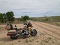
As far as I could get on the bike.
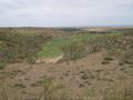
Looking in the direction of the (not reached) geohash, about three kilometers away.

