Difference between revisions of "2021-05-24 50 7"
From Geohashing
Gefrierbrand (talk | contribs) (Created page with "{{subst:Expedition}}") |
Gefrierbrand (talk | contribs) |
||
| (9 intermediate revisions by 2 users not shown) | |||
| Line 1: | Line 1: | ||
| − | + | {{meetup graticule | |
| − | |||
| − | |||
| − | |||
| − | |||
| − | |||
| − | |||
| − | |||
| − | |||
| lat={{#explode:{{SUBPAGENAME}}| |1}} | | lat={{#explode:{{SUBPAGENAME}}| |1}} | ||
| lon={{#explode:{{SUBPAGENAME}}| |2}} | | lon={{#explode:{{SUBPAGENAME}}| |2}} | ||
| date={{#explode:{{SUBPAGENAME}}| |0}} | | date={{#explode:{{SUBPAGENAME}}| |0}} | ||
| − | }} | + | }} |
__NOTOC__ | __NOTOC__ | ||
== Location == | == Location == | ||
| − | + | On a meadow near Arzbach not far from a reconstructed Limes guard tower | |
== Participants == | == Participants == | ||
| − | + | *[[User:Gefrierbrand|Gefrierbrand]] | |
| − | + | *[[User:Santu|Santu]] | |
| − | + | *Pedro the dog | |
| − | |||
| − | |||
== Expedition == | == Expedition == | ||
| − | + | *detour on way home | |
| + | *strange 'music' from group of people partying in the area | ||
| + | *great opportunity to visit limes guard tower | ||
| + | *bad weather | ||
| + | *Santu carried Pedro up the stairs | ||
| + | *windy wet and cold, but great view | ||
| + | *almost no fear of heights for Gefrierbrand | ||
| + | *continue to hashlocation downhill on disused forest paths | ||
| + | *celebrations with stupid grin | ||
| + | *walk back and continue drive home | ||
| − | + | == Photos == | |
| − | |||
| − | |||
| − | == Photos == | ||
| − | |||
| − | |||
| − | |||
<gallery perrow="5"> | <gallery perrow="5"> | ||
| + | File:2021-05-24_50_7 woodenowl.jpg | carved wooden owl | ||
| + | File:2021-05-24_50_7 limesturmwithsantu.jpg | Santu in front of the Limes tower | ||
| + | File:2021-05-24_50_7 stephansturm.jpg | Stephansturm up close | ||
| + | File:2021-05-24_50_7 infoboard.jpg | Infoboard | ||
| + | File:2021-05-24_50_7 view from tower.jpg | view from the tower | ||
| + | File:2021-05-24_50_7 smile on tower.jpg | smiling on the balcony | ||
| + | File:2021-05-24_50_7 interesting terrain.jpg | interesting terrain on the way to the hash | ||
| + | File:2021-05-24_50_7 stupidgrin.jpg | StupidGrin<sup>TM</sup> | ||
</gallery> | </gallery> | ||
== Achievements == | == Achievements == | ||
{{#vardefine:ribbonwidth|800px}} | {{#vardefine:ribbonwidth|800px}} | ||
| − | + | {{land geohash | |
| − | + | | latitude = 50 | |
| − | + | | longitude = 7 | |
| − | + | | date = 2021-05-24 | |
| − | + | | name = Santu & Gefrierbrand | |
| − | + | }} | |
| − | |||
| − | |||
| − | |||
| − | |||
| − | |||
| − | |||
| − | |||
| − | |||
| − | |||
| − | |||
[[Category:Expeditions]] | [[Category:Expeditions]] | ||
| − | |||
[[Category:Expeditions with photos]] | [[Category:Expeditions with photos]] | ||
| − | |||
| − | |||
| − | |||
| − | |||
| − | |||
[[Category:Coordinates reached]] | [[Category:Coordinates reached]] | ||
| − | + | [[Category:Expeditions with dogs]] | |
| − | + | {{location|DE|RP|EMS}} | |
| − | |||
| − | |||
| − | |||
| − | |||
| − | |||
| − | |||
| − | |||
| − | |||
| − | |||
| − | |||
| − | [[Category: | ||
| − | |||
| − | |||
| − | |||
| − | |||
| − | |||
Latest revision as of 07:55, 18 October 2022
| Mon 24 May 2021 in 50,7: 50.3713875, 7.7534261 geohashing.info google osm bing/os kml crox |
Location
On a meadow near Arzbach not far from a reconstructed Limes guard tower
Participants
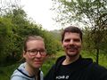
- Gefrierbrand
- Santu
- Pedro the dog
Expedition
- detour on way home
- strange 'music' from group of people partying in the area
- great opportunity to visit limes guard tower
- bad weather
- Santu carried Pedro up the stairs
- windy wet and cold, but great view
- almost no fear of heights for Gefrierbrand
- continue to hashlocation downhill on disused forest paths
- celebrations with stupid grin
- walk back and continue drive home
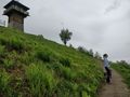
Photos
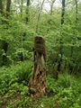
carved wooden owl
Santu in front of the Limes tower
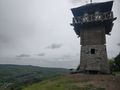
Stephansturm up close
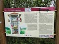
Infoboard
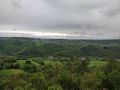
view from the tower
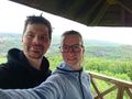
smiling on the balcony
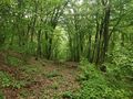
interesting terrain on the way to the hash
StupidGrinTM


Achievements
Santu & Gefrierbrand earned the Land geohash achievement
|