Difference between revisions of "2021-05-27 -37 144"
(Created page with "{{subst:Expedition}}") |
|||
| (6 intermediate revisions by 2 users not shown) | |||
| Line 14: | Line 14: | ||
__NOTOC__ | __NOTOC__ | ||
== Location == | == Location == | ||
| − | + | On the side of the road in an industrial estate of Campbellfield. | |
== Participants == | == Participants == | ||
| − | + | [[User:Stevage|Stevage]] | |
| − | |||
== Plans == | == Plans == | ||
| − | + | It was Felix's idea, but then Melbourne went into lockdown and he wasn't up for it. | |
== Expedition == | == Expedition == | ||
| − | + | === Getting there === | |
| + | I got on my bike and rode there. Mostly that part was straightforward, although construction along the freeway meant that the main bike bridge was out of action, so I had to go further along a busy road. | ||
| + | |||
| + | I listened to a podcast about a fan theory of Sherlock Holmes and John Watson having a romantic relationship (known as "John/Lock"). | ||
| + | |||
| + | When I arrived, since it was mid afternoon, there were actually lots of people working at various factories. I got a few suspicious glances. | ||
| + | |||
| + | I rode to where I thought the spot was, and...it was there. No faffing about. Straight on. Nailed it. | ||
| + | |||
| + | Then, and I turned to go home, and the adventure really began. | ||
| + | |||
| + | === Return === | ||
| + | Keen to avoid the busy road again, but too lazy to really look closely at the map, I took a quick glance and saw some kind of paths along Edgars Creek. I set off to vaguely follow the creek, following my nose rather than looking at the map. | ||
| + | |||
| + | At first it basically meant back streets - there was no way to actually ride next to the creek. | ||
| + | |||
| + | Then there was a way onto some grass. Kind of rideable. Not really a path. Then a path! I followed it. With hope. And mounting expectations. | ||
| + | |||
| + | Then the path suddenly veered away from the creek, up a very steep embankment with a sheer drop. Just a skinny little goat track wedged between a fence and a kind of cliff. Mud. It had been raining. Very slippery. So slippery. Yikes. This would end badly. | ||
| + | |||
| + | I dismounted and gingerly started up. My bike shoes have terrible grip. I slid. I advanced. I slid back. I hoisted my bike over my shoulder. I looked out for small chunks of broken brick through the mud. Delicately balanced my weight over them. They were far apart. Too far. I was balanced on one foot. Bike balanced precariously over the void. This was a bad idea. But bad ideas are good ideas. | ||
| + | |||
| + | In my ear, a podcast about the ill fated 1898 Belgian expedition to Antarctica. Hopefully I would not end up stuck in sea ice for a whole winter. | ||
| + | |||
| + | I awkwardly took a big step forward to try to get to the next brick foothold. I landed. I missed. I succeeded. And failed. I was face down. Sliding backwards. Covered in mud. But not yet stuck in sea ice. My bike up the hill. Salvageable. No scurvy yet. No broken bones. | ||
| + | |||
| + | I winced. Gathered myself. Started up again. Did everything the same. It went better. Reached the top. Remounted. | ||
| + | |||
| + | The goat track got better and worse, all at once. Less muddy, more precarious. No polar bears. Tree roots though. Should I cross the stream? Or not. Where was I? Keep heading south. Not as far as the south pole. | ||
| + | |||
| + | The track morphed into something more rideable, then into nothingness. Suddenly a massive bike bridge. Civilisation. Hope. Ignominy. Home. | ||
| − | |||
| − | |||
== Photos == | == Photos == | ||
| − | |||
| − | |||
| − | |||
<gallery perrow="5"> | <gallery perrow="5"> | ||
| + | Image:20210527_160632_HDR.jpg|Piece of cake | ||
</gallery> | </gallery> | ||
== Achievements == | == Achievements == | ||
{{#vardefine:ribbonwidth|800px}} | {{#vardefine:ribbonwidth|800px}} | ||
| + | {{bicycle geohash | ||
| + | | latitude={{#explode:{{SUBPAGENAME}}| |1}} | ||
| + | | longitude={{#explode:{{SUBPAGENAME}}| |2}} | ||
| + | | date={{#explode:{{SUBPAGENAME}}| |0}} | ||
| + | }} | ||
<!-- Add any achievement ribbons you earned below, or remove this section --> | <!-- Add any achievement ribbons you earned below, or remove this section --> | ||
| − | |||
| − | |||
| − | |||
| − | |||
| − | |||
| − | |||
| − | |||
| − | |||
| − | |||
| − | |||
| − | |||
| − | |||
| − | |||
| − | |||
[[Category:Expeditions]] | [[Category:Expeditions]] | ||
| − | |||
| − | |||
| − | |||
| − | |||
| − | |||
| − | |||
| − | |||
[[Category:Coordinates reached]] | [[Category:Coordinates reached]] | ||
| − | + | {{location|AU|VIC|HU}} | |
| − | |||
| − | |||
| − | |||
| − | |||
| − | |||
| − | |||
| − | |||
| − | |||
| − | |||
| − | |||
| − | |||
| − | |||
| − | |||
| − | |||
| − | |||
| − | |||
| − | |||
Latest revision as of 06:38, 15 August 2023
| Thu 27 May 2021 in -37,144: -37.6608967, 144.9639409 geohashing.info google osm bing/os kml crox |
Location
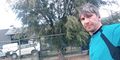
On the side of the road in an industrial estate of Campbellfield.
Participants
Plans
It was Felix's idea, but then Melbourne went into lockdown and he wasn't up for it.
Expedition
Getting there
I got on my bike and rode there. Mostly that part was straightforward, although construction along the freeway meant that the main bike bridge was out of action, so I had to go further along a busy road.
I listened to a podcast about a fan theory of Sherlock Holmes and John Watson having a romantic relationship (known as "John/Lock").
When I arrived, since it was mid afternoon, there were actually lots of people working at various factories. I got a few suspicious glances.
I rode to where I thought the spot was, and...it was there. No faffing about. Straight on. Nailed it.
Then, and I turned to go home, and the adventure really began.
Return
Keen to avoid the busy road again, but too lazy to really look closely at the map, I took a quick glance and saw some kind of paths along Edgars Creek. I set off to vaguely follow the creek, following my nose rather than looking at the map.
At first it basically meant back streets - there was no way to actually ride next to the creek.
Then there was a way onto some grass. Kind of rideable. Not really a path. Then a path! I followed it. With hope. And mounting expectations.
Then the path suddenly veered away from the creek, up a very steep embankment with a sheer drop. Just a skinny little goat track wedged between a fence and a kind of cliff. Mud. It had been raining. Very slippery. So slippery. Yikes. This would end badly.
I dismounted and gingerly started up. My bike shoes have terrible grip. I slid. I advanced. I slid back. I hoisted my bike over my shoulder. I looked out for small chunks of broken brick through the mud. Delicately balanced my weight over them. They were far apart. Too far. I was balanced on one foot. Bike balanced precariously over the void. This was a bad idea. But bad ideas are good ideas.
In my ear, a podcast about the ill fated 1898 Belgian expedition to Antarctica. Hopefully I would not end up stuck in sea ice for a whole winter.
I awkwardly took a big step forward to try to get to the next brick foothold. I landed. I missed. I succeeded. And failed. I was face down. Sliding backwards. Covered in mud. But not yet stuck in sea ice. My bike up the hill. Salvageable. No scurvy yet. No broken bones.
I winced. Gathered myself. Started up again. Did everything the same. It went better. Reached the top. Remounted.
The goat track got better and worse, all at once. Less muddy, more precarious. No polar bears. Tree roots though. Should I cross the stream? Or not. Where was I? Keep heading south. Not as far as the south pole.
The track morphed into something more rideable, then into nothingness. Suddenly a massive bike bridge. Civilisation. Hope. Ignominy. Home.
Photos
Piece of cake

Achievements
This user earned the Bicycle geohash achievement
|