Difference between revisions of "2021-05-28 42 -85"
(create expedition page) |
(→Tracklog) |
||
| (10 intermediate revisions by 2 users not shown) | |||
| Line 1: | Line 1: | ||
| − | + | {{meetup graticule | |
| − | + | | lat=42 | |
| − | + | | lon=-85 | |
| − | + | | date=2021-05-28 | |
| − | + | }} | |
| − | |||
| − | |||
| − | |||
| − | |||
| − | | lat= | ||
| − | | lon= | ||
| − | | date= | ||
| − | }} | ||
__NOTOC__ | __NOTOC__ | ||
== Location == | == Location == | ||
| − | + | A few meters off of a trail in the Upper Macatawa Natural Area, near Zeeland MI. | |
== Participants == | == Participants == | ||
| − | + | [[User:Alison|Alison]] ([[User talk:Alison|talk]]) | |
| − | |||
== Plans == | == Plans == | ||
| − | + | The hashpoint is only about a 25-minute drive west of my partners’ apartment in Wyoming, and I was already driving out here on Friday night to visit them. So I planned on passing their exit and visiting the hashpoint, then stopping at a grocery store on my way back to their apartment to bring them some requested turkey bacon. | |
== Expedition == | == Expedition == | ||
| − | + | I was able to reach the Upper Macatawa Natural Area parking by car without issue, and I didn’t even stop along the way for anything. (I usually have to stop about an hour into a drive for some reason, but I was able to drive about 2.5 hours without a break.) Then I walked along the trail to the hashpoint and back. | |
| + | |||
| + | When I returned to my car, I looked up the nearest Kroger locations, only to find that Kroger isn’t a thing in west Michigan, so I was unable to acquire the requested turkey bacon. Also, I splashed in a mud puddle on my drive back out to the main road so I now need to wash my car again. | ||
== Tracklog == | == Tracklog == | ||
| − | |||
| − | == Photos == | + | {{tracklog|2021-05-28 42 -85.gpx}} |
| − | + | ||
| − | + | == Photos == | |
| − | |||
<gallery perrow="5"> | <gallery perrow="5"> | ||
| + | Image:2021-05-28 42 -85 parked up.jpg | Parked up in the Upper Macatawa Natural Area parking lot. | ||
| + | Image:2021-05-28 42 -85 bridge.jpg | A bridge along the trail. | ||
| + | Image:2021-05-28 42 -85 low creek.jpg | A low creek under the bridge. | ||
| + | Image:2021-05-28 42 -85 unpaved trail.jpg | The trail becomes unpaved, and the land less forested. | ||
| + | Image:2021-05-28 42 -85 almost no trespassing.jpg | Only a few metres away from becoming No Trespassing | ||
| + | Image:2021-05-28 42 -85 proof.jpg | Proof of reaching the hashpoint | ||
| + | Image:2021-05-28 42 -85 selfie.jpg | The obligatory selfie | ||
</gallery> | </gallery> | ||
== Achievements == | == Achievements == | ||
{{#vardefine:ribbonwidth|800px}} | {{#vardefine:ribbonwidth|800px}} | ||
| − | |||
| − | |||
| − | |||
| − | |||
| − | |||
| − | |||
| − | |||
| − | |||
| − | |||
| − | |||
| − | |||
| − | |||
| − | |||
| − | |||
| − | |||
| − | |||
[[Category:Expeditions]] | [[Category:Expeditions]] | ||
| − | + | [[Category:Expeditions with photos]] | |
| − | [[Category:Expeditions with photos]] | ||
| − | |||
| − | |||
| − | |||
| − | |||
| − | |||
[[Category:Coordinates reached]] | [[Category:Coordinates reached]] | ||
| − | + | {{location|US|MI|OT}} | |
| − | |||
| − | |||
| − | |||
| − | |||
| − | |||
| − | |||
| − | |||
| − | |||
| − | |||
| − | |||
| − | |||
| − | |||
| − | |||
| − | |||
| − | |||
| − | |||
| − | |||
Latest revision as of 21:41, 23 June 2021
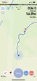
| Fri 28 May 2021 in 42,-85: 42.8027918, -85.9749452 geohashing.info google osm bing/os kml crox |
Location
A few meters off of a trail in the Upper Macatawa Natural Area, near Zeeland MI.
Participants
Plans
The hashpoint is only about a 25-minute drive west of my partners’ apartment in Wyoming, and I was already driving out here on Friday night to visit them. So I planned on passing their exit and visiting the hashpoint, then stopping at a grocery store on my way back to their apartment to bring them some requested turkey bacon.
Expedition
I was able to reach the Upper Macatawa Natural Area parking by car without issue, and I didn’t even stop along the way for anything. (I usually have to stop about an hour into a drive for some reason, but I was able to drive about 2.5 hours without a break.) Then I walked along the trail to the hashpoint and back.
When I returned to my car, I looked up the nearest Kroger locations, only to find that Kroger isn’t a thing in west Michigan, so I was unable to acquire the requested turkey bacon. Also, I splashed in a mud puddle on my drive back out to the main road so I now need to wash my car again.
Tracklog
Photos
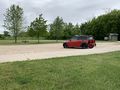
Parked up in the Upper Macatawa Natural Area parking lot.
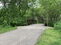
A bridge along the trail.
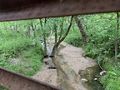
A low creek under the bridge.
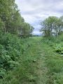
The trail becomes unpaved, and the land less forested.
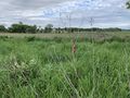
Only a few metres away from becoming No Trespassing
Proof of reaching the hashpoint
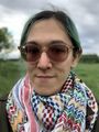
The obligatory selfie


