Difference between revisions of "2021-06-01 63 30"
| (7 intermediate revisions by 2 users not shown) | |||
| Line 3: | Line 3: | ||
| lon={{#explode:{{SUBPAGENAME}}| |2}} | | lon={{#explode:{{SUBPAGENAME}}| |2}} | ||
| date={{#explode:{{SUBPAGENAME}}| |0}} | | date={{#explode:{{SUBPAGENAME}}| |0}} | ||
| − | }} | + | }} |
__NOTOC__ | __NOTOC__ | ||
== Location == | == Location == | ||
| Line 14: | Line 14: | ||
== Expedition == | == Expedition == | ||
| − | + | This location was quite convenient to cycle to and in a new graticule for me. I planned my schedule so that I could cycle to the hashpoint and get back to Uimaharju by 17:00, where I would be able to catch a train to Joensuu at 17:08. The weather would be perfect: partly cloudy and about 20 °C, warm but not too hot. | |
| − | + | I started from my home at about 10:50 and cycled towards the hashpoint, stopping at a few geocaches and a few beautiful places that I wanted to photograph. I felt good enough and confident that I could cycle all the way back home, so I ended up spending excessive time at some points. I saw many beautiful landscapes along the way: fields, the Pielisjoki river, streams, ponds, hills, forests and open logging areas. The roads got progressively smaller from the main road 73 to a narrower connecting road, an unpaved gravel road, a single-track forest road and finally a tractor track. I also had to climb from 80 metres above sea level in Joensuu to 100 m in Uimaharju and 235 m at the geohash. The last climbs on the forest road were especially steep and tiring, but I made it. | |
| − | + | ||
| − | + | I reached the hashpoint at about 15:45. It was almost at the top of a hill that had been cleared recently, probably during the past year. After taking a some photos, I began the return trip. I would have some significant descent ahead of me and enough time to get back to Uimaharju before the train departure, but again I decided that I could spend some time photographing and geocaching and did not need to use the train. So then, I made my way to Uimaharju, had a large [https://en.wikipedia.org/wiki/Lihapiirakka Finnish meat pie] with sausage and an ice cream at the summer café at the rivershore, and cycled back home at a calm pace. | |
| + | |||
| + | I was back at home at about 20:50, ten hours after leaving. According to my GPS receiver, the length of my trip was 143.2 kilometres long, of which I cycled 142.7 km and walked 0.5 km. This was my yet longest [[Bicycle geohash achievement|Bicycle Geohash]] and just barely longer than the distance I cycled on [[2020-06-26 62 28|2020-06-26 62 28]]. My skin was surprisingly not burned despite spending ten hours in more or less direct sunshine. | ||
== Tracklog == | == Tracklog == | ||
| + | I visited a Wherigo cache and two multicaches on the way, and in order to not reveal the final locations, I removed small parts of the tracklog. | ||
| + | |||
{{tracklog | 2021-06-01 63 30 Tracklog.gpx}} | {{tracklog | 2021-06-01 63 30 Tracklog.gpx}} | ||
== Photos == | == Photos == | ||
| − | < | + | I know, some of the panoramas are terrible in the borders between individual images... They were the best I could get without too much effort. |
| − | Image: | + | <gallery perrow="6"> |
| − | -- | + | Image:2021-06-01_63_30_01-field.jpg | A field of dandelions near Jakokoski. {{MapSiteLink | N = 6959938 | E = 652434 | title = Photo+1}} |
| − | + | Image:2021-06-01_63_30_02-louhioja.jpg | A view to the Pielisjoki river near Louhioja. {{MapSiteLink | N = 6967438 | E = 659042 | title = Photo+2}} | |
| + | Image:2021-06-01_63_30_03-rahkeenvesi.jpg | A view to Rahkeenvesi near Uimaharju. {{MapSiteLink | N = 6979369 | E = 663910 | title = Photo+3}} | ||
| + | Image:2021-06-01_63_30_04-sign.jpg | This does not spark joy... Rasputitsa for the next 34 km. It was not so bad though this late in the summer. {{MapSiteLink | N = 6990389 | E = 674502 | title = Photo+4}} | ||
| + | Image:2021-06-01_63_30_05-border.jpg | On the border of Lieksa and Ilomantsi. {{MapSiteLink | N = 6991410 | E = 673584 | title = Photo+5}} | ||
| + | Image:2021-06-01_63_30_20-hill1.jpg | A view from an unnamed hill on the way to the hashpoint. {{MapSiteLink | N = 6995357 | E = 672524 | title = Photo+6}} | ||
| + | Image:2021-06-01_63_30_06-gpsr1.jpg | Proof of location. {{MapSiteLink | N = 6995677 | E = 672931 | title = Photos+7%E2%80%939}} | ||
| + | Image:2021-06-01_63_30_07-gpsr2.jpg | Proof of date and time. {{MapSiteLink | N = 6995677 | E = 672931 | title = Photos+7%E2%80%939}} | ||
| + | Image:2021-06-01_63_30_08-selfie.jpg | Selfie at the hashpoint. {{MapSiteLink | N = 6995677 | E = 672931 | title = Photos+7%E2%80%939}} | ||
| + | Image:2021-06-01_63_30_09-hill2.jpg | A view from the top of the geohash hill. {{MapSiteLink | N = 6995667 | E = 672904 | title = Photo+10}} | ||
| + | Image:2021-06-01_63_30_10-pond.jpg | The bog-based Pieni-Hoikka pond. {{MapSiteLink | N = 6992251 | E = 673231 | title = Photos+11+%26+12}} | ||
| + | Image:2021-06-01_63_30_11-cloudberry.jpg | Blossoming cloudberry (''Rubus chamaemorus''). {{MapSiteLink | N = 6992251 | E = 673231 | title = Photos+11+%26+12}} | ||
| + | Image:2021-06-01_63_30_12-bilberry.jpg | Blossoming bilberry (''Vaccinium myrtillus''). {{MapSiteLink | N = 6992268 | E = 673248 | title = Photo+13}} | ||
| + | Image:2021-06-01_63_30_13-swans.jpg | A pair of whooper swans (''Cygnus cygnus''), the national bird of Finland. {{MapSiteLink | N = 6989962 | E = 674900 | title = Photo+14}} | ||
| + | Image:2021-06-01_63_30_14-marsh.jpg | A small marsh near the road. {{MapSiteLink | N = 6988714 | E = 675486 | title = Photo+15}} | ||
| + | Image:2021-06-01_63_30_15-summercafé.jpg | The summer café in Uimaharju and the surroundings. {{MapSiteLink | N = 6979371 | E = 664000 | title = Photos+16+%26+17}} | ||
| + | Image:2021-06-01_63_30_16-icecream.jpg | The delicious cone of ice cream. {{MapSiteLink | N = 6979371 | E = 664000 | title = Photos+16+%26+17}} | ||
| + | Image:2021-06-01_63_30_17-kuusoja.jpg | The Kuusoja stream. {{MapSiteLink | N = 6962722 | E = 654991 | title = Photo+18}} | ||
</gallery> | </gallery> | ||
| − | == | + | == Video == |
| − | + | I filmed a part of my way back to Uimaharju and uploaded the video. The audio consists mostly of bicycle sounds and the noise of the wind and nothing interesting – you can mute it if you do not want to listen to it. Watching at double speed might be a good idea. | |
| − | |||
| − | < | + | <youtube>https://youtu.be/oarkNGN1j4E</youtube> |
| − | |||
| − | |||
| − | + | YouTube link: [https://www.youtube.com/watch?v=oarkNGN1j4E] | |
| − | + | == Achievements == | |
| − | + | {{#vardefine:ribbonwidth|800px}} | |
| − | + | {{land geohash | latitude = 63 | longitude = 30 | date = 2021-06-01 | name = Kripakko}} | |
| − | + | {{bicycle geohash | latitude = 63 | longitude = 30 | date = 2021-06-01 | name = Kripakko | distance = 142.7 km | bothways = true}} | |
| + | {{Minesweeper geohash | graticule = Joensuu, Finland | ranknumber = 6 | n = true | e = true | se = true | s = true | w = true | ne = true | name = Kripakko}} | ||
| − | |||
| − | |||
| − | |||
[[Category:Expeditions]] | [[Category:Expeditions]] | ||
| − | |||
[[Category:Expeditions with photos]] | [[Category:Expeditions with photos]] | ||
[[Category:Expeditions with videos]] | [[Category:Expeditions with videos]] | ||
| − | |||
| − | |||
| − | |||
| − | |||
[[Category:Coordinates reached]] | [[Category:Coordinates reached]] | ||
| − | + | {{location|FI|13}} | |
| − | |||
| − | |||
| − | |||
| − | |||
| − | |||
| − | |||
| − | |||
| − | |||
| − | |||
| − | |||
| − | |||
| − | |||
| − | |||
| − | |||
| − | |||
| − | |||
| − | |||
Latest revision as of 22:53, 5 June 2021
| Tue 1 Jun 2021 in 63,30: 63.0492212, 30.4210265 geohashing.info google osm bing/os kml crox |
Location
Next to a tractor track near Kuora, Lieksa.
The point on a topographic map: [19]
Participants
Expedition
This location was quite convenient to cycle to and in a new graticule for me. I planned my schedule so that I could cycle to the hashpoint and get back to Uimaharju by 17:00, where I would be able to catch a train to Joensuu at 17:08. The weather would be perfect: partly cloudy and about 20 °C, warm but not too hot.
I started from my home at about 10:50 and cycled towards the hashpoint, stopping at a few geocaches and a few beautiful places that I wanted to photograph. I felt good enough and confident that I could cycle all the way back home, so I ended up spending excessive time at some points. I saw many beautiful landscapes along the way: fields, the Pielisjoki river, streams, ponds, hills, forests and open logging areas. The roads got progressively smaller from the main road 73 to a narrower connecting road, an unpaved gravel road, a single-track forest road and finally a tractor track. I also had to climb from 80 metres above sea level in Joensuu to 100 m in Uimaharju and 235 m at the geohash. The last climbs on the forest road were especially steep and tiring, but I made it.
I reached the hashpoint at about 15:45. It was almost at the top of a hill that had been cleared recently, probably during the past year. After taking a some photos, I began the return trip. I would have some significant descent ahead of me and enough time to get back to Uimaharju before the train departure, but again I decided that I could spend some time photographing and geocaching and did not need to use the train. So then, I made my way to Uimaharju, had a large Finnish meat pie with sausage and an ice cream at the summer café at the rivershore, and cycled back home at a calm pace.
I was back at home at about 20:50, ten hours after leaving. According to my GPS receiver, the length of my trip was 143.2 kilometres long, of which I cycled 142.7 km and walked 0.5 km. This was my yet longest Bicycle Geohash and just barely longer than the distance I cycled on 2020-06-26 62 28. My skin was surprisingly not burned despite spending ten hours in more or less direct sunshine.
Tracklog
I visited a Wherigo cache and two multicaches on the way, and in order to not reveal the final locations, I removed small parts of the tracklog.
Photos
I know, some of the panoramas are terrible in the borders between individual images... They were the best I could get without too much effort.
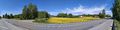
A field of dandelions near Jakokoski. [1]
A view to the Pielisjoki river near Louhioja. [2]
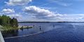
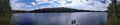
A view to Rahkeenvesi near Uimaharju. [3]
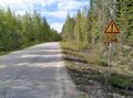
This does not spark joy... Rasputitsa for the next 34 km. It was not so bad though this late in the summer. [4]
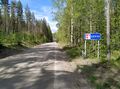
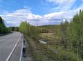
On the border of Lieksa and Ilomantsi. [5]
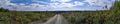
A view from an unnamed hill on the way to the hashpoint. [6]
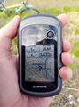
Proof of location. [7]
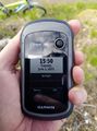
Proof of date and time. [8]
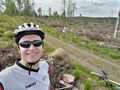
Selfie at the hashpoint. [9]
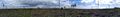
A view from the top of the geohash hill. [10]
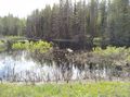
The bog-based Pieni-Hoikka pond. [11]
Blossoming cloudberry (Rubus chamaemorus). [12]
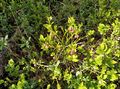
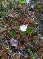
Blossoming bilberry (Vaccinium myrtillus). [13]
A pair of whooper swans (Cygnus cygnus), the national bird of Finland. [14]
A small marsh near the road. [15]
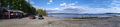
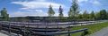
The summer café in Uimaharju and the surroundings. [16]
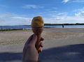
The delicious cone of ice cream. [17]
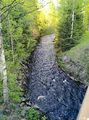
The Kuusoja stream. [18]


Video
I filmed a part of my way back to Uimaharju and uploaded the video. The audio consists mostly of bicycle sounds and the noise of the wind and nothing interesting – you can mute it if you do not want to listen to it. Watching at double speed might be a good idea.
YouTube link: [20]
Achievements
Kripakko earned the Land geohash achievement
|
Kripakko earned the Bicycle geohash achievement
|
Kripakko achieved level 6 of the Minesweeper Geohash achievement
|