Difference between revisions of "2021-06-04 49 8"
Gefrierbrand (talk | contribs) ([retro] proof) |
Gefrierbrand (talk | contribs) |
||
| (10 intermediate revisions by 2 users not shown) | |||
| Line 1: | Line 1: | ||
| − | + | {{meetup graticule | |
| − | |||
| − | |||
| − | |||
| − | |||
| − | |||
| − | |||
| − | |||
| − | |||
| lat=49 | | lat=49 | ||
| lon=8 | | lon=8 | ||
| date=2021-06-04 | | date=2021-06-04 | ||
| − | }} | + | }}__NOTOC__ |
| − | __NOTOC__ | ||
== Location == | == Location == | ||
| − | + | on a forest trail near Mörfelden | |
| − | |||
== Participants == | == Participants == | ||
| − | + | *[[User:Santu|Santu]] | |
| − | + | *[[User:Gefrierbrand|Gefrierbrand]] | |
| − | + | *Pedro the dog | |
| − | |||
| − | |||
== Expedition == | == Expedition == | ||
| − | + | On our way to the hash point suddenly a KFC appeared in front of us and even though we already have had dinner, there was no way of passing by. So a spontaneous second dinner was unavoidable, which was executed within short time on a fallen tree near the hash. After this strengthening meal (although not for Pedro) we walked towards the hash on a medium sized forest road, wondering if the shapes at its end were approaching people or street signs. | |
| − | |||
| − | + | It was not a great challenge to get to the hash, as we could make use of a small path, which was visible on the map only at certain weird zoom levels. Reached hash point without problems. Right next to us there was a small mysterious muddy pond hidden behind shrubbery. Sadly we weren't able to get any closer to it. | |
| − | + | After a quick look around we headed back to the car. While on our way we heard a gunshot behind us, probably from a hunter. To prevent being mistaken for a deer Santu called out "I'm no deer. Mooooo!". About half way back Gefrierbrand noticed an old slightly overgrown bench which was not yet properly marked in open street map. So he carefully noted the coordinates and later edited it in OSM. | |
| − | + | Due to the short distance to the airport Frankfurt we used the opportunity to visit a plane spotting point near cargocity south. As it already grew darker the lights on the runways and planes as well as from the passing by traffic on the A5 presented a spectacular view. Westwards of our location a thunderstorm was visible, so we could enjoy the fascinating phenomenon of lightning from a safe distance. Next to the view point there was a memorial for the Berlin Airlift which we visited. Right before the storm reached us we went back to the parking lot. It was perfect timing! Shortly after being on the road again, we entered the massive thunderstorm, which forced the traffic to slow down drastically. It took almost an hour to drive through it. | |
| − | |||
| − | |||
| − | |||
| − | |||
| − | |||
| − | |||
| − | |||
| − | |||
| − | |||
| − | |||
== Photos == | == Photos == | ||
| − | |||
| − | |||
| − | |||
<gallery perrow="5"> | <gallery perrow="5"> | ||
| + | File:2021-06-04 49 8 food.jpg | second dinner | ||
| + | File:2021-06-04 49 8 almost there.jpg | almost at the hash | ||
| + | File:2021-06-04 49 8 stupid grin.jpg | StupidGrin<sup>TM</sup> | ||
| + | File:2021-06-04 49 8 fallen tree.jpg | fallen Tree near hashlocation | ||
| + | File:2021-06-04 49 8 general area.jpg | general area | ||
| + | File:2021-06-04 49 8 bench measuring.jpg | taking bench coordinates | ||
| + | File:2021-06-04 49 8 approaching storm.jpg | approaching thunderstorm | ||
| + | File:2021-06-04 49 8 rundway lights.jpg | runway lights | ||
| + | File:2021-06-04 49 8 747 in distance.jpg | 747 (?) in the distance | ||
| + | File:2021-06-04 49 8 planespotting.jpg | plane spotting | ||
| + | File:2021-06-04 49 8 rosinenbomber.jpg | Santu in front of Rosinenbomber | ||
| + | File:2021-06-04 49 8 airlift.jpg | Gefrierbrand & Pedro in front of plane | ||
| + | File:2021-06-04 49 8 momument.jpg | Berlin Airlift Monument | ||
| + | File:2021-06-04 49 8 proof.jpg | proof | ||
</gallery> | </gallery> | ||
== Achievements == | == Achievements == | ||
{{#vardefine:ribbonwidth|800px}} | {{#vardefine:ribbonwidth|800px}} | ||
| − | + | {{land geohash | |
| − | + | | latitude = 49 | |
| − | + | | longitude = 8 | |
| − | + | | date = 2021-06-04 | |
| − | + | | name = Santu & Gefrierbrand | |
| − | + | }} | |
| − | + | {{OpenStreetMap achievement | |
| − | + | | latitude = 49 | |
| − | + | | longitude = 8 | |
| − | + | | date = 2021-06-04 | |
| − | + | | OSMlink = 105875598 | |
| − | -- | + | | name = Gefrierbrand |
| − | + | }} | |
| − | |||
| − | |||
| − | |||
[[Category:Expeditions]] | [[Category:Expeditions]] | ||
| − | |||
[[Category:Expeditions with photos]] | [[Category:Expeditions with photos]] | ||
| − | |||
| − | |||
| − | |||
| − | |||
| − | |||
[[Category:Coordinates reached]] | [[Category:Coordinates reached]] | ||
| − | + | [[Category:Expeditions with dogs]] | |
| − | + | {{location|DE|HE|GG}} | |
| − | |||
| − | |||
| − | |||
| − | |||
| − | |||
| − | |||
| − | |||
| − | |||
| − | |||
| − | |||
| − | [[Category: | ||
| − | |||
| − | |||
| − | |||
| − | |||
| − | |||
Latest revision as of 07:55, 18 October 2022
| Fri 4 Jun 2021 in 49,8: 49.9612468, 8.5884644 geohashing.info google osm bing/os kml crox |
Location
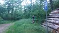
on a forest trail near Mörfelden
Participants
- Santu
- Gefrierbrand
- Pedro the dog
Expedition
On our way to the hash point suddenly a KFC appeared in front of us and even though we already have had dinner, there was no way of passing by. So a spontaneous second dinner was unavoidable, which was executed within short time on a fallen tree near the hash. After this strengthening meal (although not for Pedro) we walked towards the hash on a medium sized forest road, wondering if the shapes at its end were approaching people or street signs.
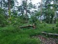
It was not a great challenge to get to the hash, as we could make use of a small path, which was visible on the map only at certain weird zoom levels. Reached hash point without problems. Right next to us there was a small mysterious muddy pond hidden behind shrubbery. Sadly we weren't able to get any closer to it.
After a quick look around we headed back to the car. While on our way we heard a gunshot behind us, probably from a hunter. To prevent being mistaken for a deer Santu called out "I'm no deer. Mooooo!". About half way back Gefrierbrand noticed an old slightly overgrown bench which was not yet properly marked in open street map. So he carefully noted the coordinates and later edited it in OSM.
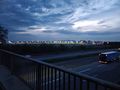
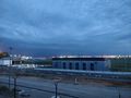
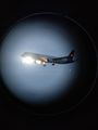
Due to the short distance to the airport Frankfurt we used the opportunity to visit a plane spotting point near cargocity south. As it already grew darker the lights on the runways and planes as well as from the passing by traffic on the A5 presented a spectacular view. Westwards of our location a thunderstorm was visible, so we could enjoy the fascinating phenomenon of lightning from a safe distance. Next to the view point there was a memorial for the Berlin Airlift which we visited. Right before the storm reached us we went back to the parking lot. It was perfect timing! Shortly after being on the road again, we entered the massive thunderstorm, which forced the traffic to slow down drastically. It took almost an hour to drive through it.
Photos
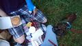
second dinner
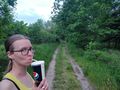
almost at the hash

StupidGrinTM
fallen Tree near hashlocation
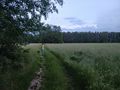
general area
taking bench coordinates
approaching thunderstorm
runway lights
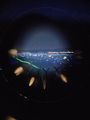
747 (?) in the distance
plane spotting
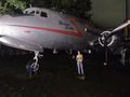
Santu in front of Rosinenbomber
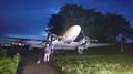
Gefrierbrand & Pedro in front of plane
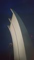
Berlin Airlift Monument
proof


Achievements
Santu & Gefrierbrand earned the Land geohash achievement
|
Gefrierbrand earned the OpenStreetMap achievement
|