Difference between revisions of "2021-06-24 50 7"
Gefrierbrand (talk | contribs) (→Location) |
Gefrierbrand (talk | contribs) |
||
| Line 1: | Line 1: | ||
| − | + | {{meetup graticule | |
| − | |||
| − | |||
| − | |||
| − | |||
| − | |||
| − | |||
| − | |||
| − | |||
| lat=50 | | lat=50 | ||
| lon=7 | | lon=7 | ||
| date=2021-06-24 | | date=2021-06-24 | ||
| − | }} | + | }} |
__NOTOC__ | __NOTOC__ | ||
== Location == | == Location == | ||
| Line 17: | Line 9: | ||
== Participants == | == Participants == | ||
| − | + | *[[User:Santu|Santu]] | |
| − | + | *[[User:Gefrierbrand|Gefrierbrand]] | |
| + | *Pedro the dog | ||
== Plans == | == Plans == | ||
| − | + | Well there really weren't any ;) | |
== Expedition == | == Expedition == | ||
| − | + | While continuing home from our [[2021-06-24 50 8|other adventure]], Gefrierbrand wondered if the point one graticule to the west would also be accessible – and indeed it was. Since we were traveling along a different route than usual, we only had to continue on the Autobahn instead of exiting for a bit and would then make the rest up as we go. Upon mentioning the possibility for achievements, Santu agreed. | |
| − | + | So we drove past our original destination and headed into a quite rural area with (at least to us) amusing town-names. We expected to have to find a parking spot in some village near the hash, but to our surprise the roads had no signs forbidding the use of vehicles so we were able to practically drive right next to it. This would have however blocked the narrow road and even if we didn't expect anybody else to drive along there we continued a bit to find a more suitable place to stop. | |
| − | + | ||
| + | We then were able to enter the field containing the hash using the already existing tractor-trails leading into it without damaging the plants. Luckily, the location was reachable within the GPS uncertainty from there, going of the "path" would not have been possible. Also, the plants were still really wet – Gefrierbrand who went along first and therefore "collected" most of the water had to change his clothes directly afterwards. | ||
| + | |||
| + | We then used narrow windy roads, one of which stopped in the middle of nowhere, to get back home. | ||
== Photos == | == Photos == | ||
| Line 38: | Line 34: | ||
== Achievements == | == Achievements == | ||
{{#vardefine:ribbonwidth|800px}} | {{#vardefine:ribbonwidth|800px}} | ||
| + | {{land geohash | ||
| + | | latitude = 50 | ||
| + | | longitude = 7 | ||
| + | | date = 2021-06-24 | ||
| + | | name = Santu & Gefrierbrand | ||
| + | }} | ||
{{Multihash | {{Multihash | ||
| latitude1 = 50 | | latitude1 = 50 | ||
| Line 46: | Line 48: | ||
| name = Santu & Gefrierbrand | | name = Santu & Gefrierbrand | ||
}} | }} | ||
| − | |||
| − | |||
| − | |||
| − | |||
| − | |||
| − | |||
| − | |||
| − | |||
| − | |||
| − | |||
| − | |||
| − | |||
| − | |||
| − | |||
| − | |||
[[Category:Expeditions]] | [[Category:Expeditions]] | ||
| − | |||
[[Category:Expeditions with photos]] | [[Category:Expeditions with photos]] | ||
| − | |||
| − | |||
| − | |||
| − | |||
| − | |||
[[Category:Coordinates reached]] | [[Category:Coordinates reached]] | ||
| − | |||
| − | |||
| − | |||
| − | |||
| − | |||
| − | |||
| − | |||
| − | |||
| − | |||
| − | |||
| − | |||
| − | |||
| − | |||
| − | |||
| − | |||
| − | |||
| − | |||
| − | |||
Revision as of 09:34, 25 June 2021
| Thu 24 Jun 2021 in 50,7: 50.2301366, 7.2767899 geohashing.info google osm bing/os kml crox |
Location
In a Field near Brohl
Participants
- Santu
- Gefrierbrand
- Pedro the dog
Plans
Well there really weren't any ;)
Expedition
While continuing home from our other adventure, Gefrierbrand wondered if the point one graticule to the west would also be accessible – and indeed it was. Since we were traveling along a different route than usual, we only had to continue on the Autobahn instead of exiting for a bit and would then make the rest up as we go. Upon mentioning the possibility for achievements, Santu agreed.
So we drove past our original destination and headed into a quite rural area with (at least to us) amusing town-names. We expected to have to find a parking spot in some village near the hash, but to our surprise the roads had no signs forbidding the use of vehicles so we were able to practically drive right next to it. This would have however blocked the narrow road and even if we didn't expect anybody else to drive along there we continued a bit to find a more suitable place to stop.
We then were able to enter the field containing the hash using the already existing tractor-trails leading into it without damaging the plants. Luckily, the location was reachable within the GPS uncertainty from there, going of the "path" would not have been possible. Also, the plants were still really wet – Gefrierbrand who went along first and therefore "collected" most of the water had to change his clothes directly afterwards.
We then used narrow windy roads, one of which stopped in the middle of nowhere, to get back home.
Photos
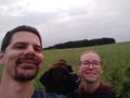
StupidGrinTM
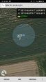
Proof
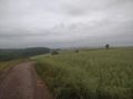
surroundings


Achievements
Santu & Gefrierbrand earned the Land geohash achievement
|
Santu & Gefrierbrand earned the Multihash Achievement
|