Difference between revisions of "2021-06-29 49 8"
From Geohashing
Gefrierbrand (talk | contribs) (→Location) |
Gefrierbrand (talk | contribs) |
||
| Line 1: | Line 1: | ||
| − | + | {{meetup graticule | |
| − | |||
| − | |||
| − | |||
| − | |||
| − | |||
| − | |||
| − | |||
| − | |||
| lat=49 | | lat=49 | ||
| lon=8 | | lon=8 | ||
| date=2021-06-29 | | date=2021-06-29 | ||
| − | }} | + | }} |
__NOTOC__ | __NOTOC__ | ||
== Location == | == Location == | ||
| Line 17: | Line 9: | ||
== Participants == | == Participants == | ||
| − | + | *[[User:Santu|Santu]] | |
| − | + | *[[User:Gefrierbrand|Gefrierbrand]] | |
| + | *Pedro the dog | ||
| − | == | + | == Expedition == |
| − | + | It was our usual geohashing adventure: take a detour along our path, drive to the hash and have fun. This time we had to venture into a field, again. But luckily it was not full of crops but just an fallow meadow. It had however rained previousy and it was muddy, slippery and of course wet all around — but this did not stop us, and neither could all the other people walking their dogs. | |
| − | + | After having successfully reached the point, we wandered around a bit and explored the nearby forest for Pedros evening-walk and then grabbed some delicious pizza before continuing home. | |
| − | |||
| − | |||
| − | |||
== Photos == | == Photos == | ||
| − | |||
| − | |||
| − | |||
<gallery perrow="5"> | <gallery perrow="5"> | ||
| − | |||
Image:2021-06-29_49_8_Gefrierbrand_1624993853127.jpg|proof | Image:2021-06-29_49_8_Gefrierbrand_1624993853127.jpg|proof | ||
| − | + | Image:2021-06-29_49_8_Gefrierbrand_1624993875589.jpg|StupidGrin<sup>TM</sup> | |
| − | Image:2021-06-29_49_8_Gefrierbrand_1624993875589.jpg|StupidGrin | ||
</gallery> | </gallery> | ||
== Achievements == | == Achievements == | ||
{{#vardefine:ribbonwidth|800px}} | {{#vardefine:ribbonwidth|800px}} | ||
| − | + | {{land geohash | |
| + | | latitude = 49 | ||
| + | | longitude = 8 | ||
| + | | date = 2021-06-29 | ||
| + | | name = Santu & Gefrerbrand | ||
| + | }} | ||
| − | |||
| − | |||
| − | |||
| − | |||
| − | |||
| − | |||
| − | |||
| − | |||
| − | |||
| − | |||
| − | |||
| − | |||
| − | |||
| − | |||
[[Category:Expeditions]] | [[Category:Expeditions]] | ||
| − | |||
[[Category:Expeditions with photos]] | [[Category:Expeditions with photos]] | ||
| − | |||
| − | |||
| − | |||
| − | |||
| − | |||
[[Category:Coordinates reached]] | [[Category:Coordinates reached]] | ||
| − | |||
| − | |||
| − | |||
| − | |||
| − | |||
| − | |||
| − | |||
| − | |||
| − | |||
| − | |||
| − | |||
| − | |||
| − | |||
| − | |||
| − | |||
| − | |||
| − | |||
| − | |||
Revision as of 17:24, 30 June 2021
| Tue 29 Jun 2021 in 49,8: 49.6782355, 8.5467589 geohashing.info google osm bing/os kml crox |
Location
In a field near Einhausen
Participants
- Santu
- Gefrierbrand
- Pedro the dog
Expedition
It was our usual geohashing adventure: take a detour along our path, drive to the hash and have fun. This time we had to venture into a field, again. But luckily it was not full of crops but just an fallow meadow. It had however rained previousy and it was muddy, slippery and of course wet all around — but this did not stop us, and neither could all the other people walking their dogs.
After having successfully reached the point, we wandered around a bit and explored the nearby forest for Pedros evening-walk and then grabbed some delicious pizza before continuing home.
Photos
proof
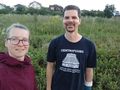
StupidGrinTM


Achievements
Santu & Gefrerbrand earned the Land geohash achievement
|