Difference between revisions of "2021-07-17 40 -3"
(Created page with "<!-- [[Image:{{{image|IMAGE}}}|thumb|left]] --> <!-- Remove this section if you don't want an image at the top (left) of your report. You should remove the "Image...") |
m (looks finished, removing Category: New report) |
||
| Line 73: | Line 73: | ||
<!-- Add any achievement ribbons you earned below, or remove | <!-- Add any achievement ribbons you earned below, or remove | ||
this section --> | this section --> | ||
| − | |||
| − | |||
| − | |||
| − | |||
| − | |||
| − | |||
| − | |||
<!-- An actual expedition: --> | <!-- An actual expedition: --> | ||
Revision as of 08:35, 21 July 2021
| Sat 17 Jul 2021 in 40,-3: 40.4157251, -3.8332640 geohashing.info google osm bing/os kml crox |
Location
In a backyard in the urbanización La Cabaña between Boadilla del Monte and Pozuelo de Alarcón.
Participants
Plans
Expedition
I knew I could not reach it. It was on private property, in a garden behind a house in a small settlement. However, this was (would have been) my first geohash in a populated area, reachable over nice country roads without much urban trafic, so I decided to go for it. It looked like comfortable streets and easy parking, so I took my heaviest motorcycle, the one called Wendy.
The trip went quite well. The road beween Brunete and Boadilla del Monte is particularly nice, with swinging curves and scenic views.
Wendy has no holder for the navigation system, so I had to remember the route, but I found the house without problems.
There stood I, hardly more than 20 meters away from the geohash, and could not reach it. But I knew that. And it was a nice tour anyway.
On the way back, I stopped at my favourite kebab shop in Valdemorillo and took something home for dinner.
Tracklog
Photos
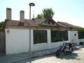
Parking in front of the premises which host the geohash.
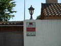
Alarm system, and a dog is barking behind the fence.
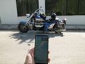
I'm only four times the accuracy away from the geohash.
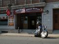
Stopover on the way home to pick up something for dinner.


