Difference between revisions of "2021-07-20 55 38"
(Created page with "{{subst:expedition}}") |
(Fill in actual content) |
||
| Line 1: | Line 1: | ||
| − | + | {{meetup graticule | |
| − | |||
| − | |||
| − | |||
| − | |||
| − | |||
| − | |||
| − | |||
| − | |||
| lat={{#explode:{{SUBPAGENAME}}| |1}} | | lat={{#explode:{{SUBPAGENAME}}| |1}} | ||
| lon={{#explode:{{SUBPAGENAME}}| |2}} | | lon={{#explode:{{SUBPAGENAME}}| |2}} | ||
| Line 14: | Line 6: | ||
__NOTOC__ | __NOTOC__ | ||
== Location == | == Location == | ||
| − | + | Near Kolomna, close to some dirt road and Moskva river. | |
== Participants == | == Participants == | ||
| − | + | * [[User:V1993|V1993]] ([[User talk:V1993|talk]]) | |
| − | |||
== Plans == | == Plans == | ||
| − | + | I found out that one of nearby hashes was surprisingly reachable, so I've planned how to get there (and somewhat planned how to get back). Given that Kolomna is full of nice places (Kremlin remains, for starters), I've picked one to visit: namely, Tramcar Museum. | |
== Expedition == | == Expedition == | ||
| − | + | So, since my bus was at 5:20 AM, I had to wake up at 4:30 AM to catch it. Trying to get onto bus also proved to be a challenge: as it turned out, supposed bus line 71 goes from route 22 to route 31 to route 71 (and you also have to pay each time it changes). Oh, and bus destination is also shown as Golutvin, which is both a region where bus terminal is located (where bus route actually ends) and also bus stop in same region (where this bus doesn't stop). And there's even more to this story later on... | |
| + | |||
| + | Once in Kolomna (at about 7:40 AM), I've decided to go get something to eat since due to hasty preparations I haven't brought any food with me, so I went to nearby KFC to discover that it opens at 8:00 AM instead of declared 6:00 AM, update OSM data and finally get to eat after a lengthy wait. | ||
| + | |||
| + | Afterwards, I returned to bus station and caught a bus to part of the city that was close to hash. After leaving the bus stop, I've started recording track and headed for hash. Eventually, street turned into dirt road as expected, and I walked into field while still following road (which, nicely, stuck to the forest border, thus keeping me in shadow). | ||
| + | |||
| + | I turned out to be pretty lucky. Since actual roads aren't mathematical lines, hash actually fell into GPS accuracy limit without any need for breaking into field (which was doable, for the record, but annoying to do). Walking to the edge of the road was well enough. After snapping some photos I've turned back, this time taking a little detour to also photograph Moskva river. | ||
| + | |||
| + | After returning to the city (and stopping track recording) I've looked up how to get to Tramcar Museum, only to discover to my dismay that it was closed today (it would only open next day). Disappointed, I've tried to remember what else worth of interest was there (as I said, there is actually a lot of cool stuff in Kolomna, but I wasn't in right mood for most of it after Tramcar Museum failure) and what came up in my mind was local factory store selling Pastila (at least, wikipedia suggests that English name is this, just a transliteration), so I went there (through rather nice city in and out of itself) and got some. | ||
| + | |||
| + | Afterwards, I got back to original bus terminal using tram (oh yes, Kolomna have functioning trams and it's delightful) and planned my route back. The catch here is that direct route Kolomna -> Stupino only goes one per day, at 9:00 AM, which was a while ago by then. As a result, I had to take bus to Ozyory and from there to Stupino. While this part went smoothly (despite having to wait for about an hour on both stops), it also includes the ending to weird numbering: surely enough, they just HAD to assign number 22 to bus route between Kolomna and Ozyory. Just why? | ||
== Tracklog == | == Tracklog == | ||
| − | + | {{Tracklog|2021-07-20 55 38 v1993.gpx}} | |
| + | |||
| + | Also [https://www.openstreetmap.org/user/vyo2003/traces/3744658 available at OSM] for closer examination. | ||
== Photos == | == Photos == | ||
| − | + | Note: there is no screenshot of hash for some reason, but check tracklog if you doubt me. | |
| − | |||
| − | |||
<gallery perrow="5"> | <gallery perrow="5"> | ||
| + | Image:2021-07-20 55 38 road.jpg | Dirt road leasing to hash | ||
| + | Image:2021-07-20 55 38 field.jpg | Free section of a field (you can see one with stuff further away) | ||
| + | Image:2021-07-20 55 38 hash.jpg | On hash location | ||
| + | Image:2021-07-20 55 38 Moskva.jpg | Moskva river | ||
| + | Image:2021-07-20 55 38 Kolomenka.jpg | And Kolomenka river, together with local ice skating complex | ||
| + | Image:2021-07-20 55 38 park.jpg | Local park, it's pretty nice | ||
| + | Image:2021-07-20 55 38 tram.jpg | Tram that got me back to bus terminal | ||
</gallery> | </gallery> | ||
== Achievements == | == Achievements == | ||
{{#vardefine:ribbonwidth|800px}} | {{#vardefine:ribbonwidth|800px}} | ||
| + | Probably nothing I don't already own. Frankly, too many of those are just undoable in my area and/or alone. | ||
<!-- Add any achievement ribbons you earned below, or remove this section --> | <!-- Add any achievement ribbons you earned below, or remove this section --> | ||
| − | |||
| − | |||
| − | |||
| − | |||
| − | |||
| − | |||
| − | |||
| − | |||
| − | |||
| − | |||
| − | |||
| − | |||
| − | |||
| − | |||
[[Category:Expeditions]] | [[Category:Expeditions]] | ||
| − | |||
[[Category:Expeditions with photos]] | [[Category:Expeditions with photos]] | ||
| − | |||
| − | |||
| − | |||
| − | |||
| − | |||
[[Category:Coordinates reached]] | [[Category:Coordinates reached]] | ||
| − | |||
| − | |||
| − | |||
| − | |||
| − | |||
| − | |||
| − | |||
| − | |||
| − | |||
| − | |||
| − | |||
| − | |||
| − | |||
| − | |||
| − | |||
| − | |||
| − | |||
| − | |||
Revision as of 16:10, 20 July 2021
| Tue 20 Jul 2021 in 55,38: 55.1130264, 38.7572393 geohashing.info google osm bing/os kml crox |
Location
Near Kolomna, close to some dirt road and Moskva river.
Participants
Plans
I found out that one of nearby hashes was surprisingly reachable, so I've planned how to get there (and somewhat planned how to get back). Given that Kolomna is full of nice places (Kremlin remains, for starters), I've picked one to visit: namely, Tramcar Museum.
Expedition
So, since my bus was at 5:20 AM, I had to wake up at 4:30 AM to catch it. Trying to get onto bus also proved to be a challenge: as it turned out, supposed bus line 71 goes from route 22 to route 31 to route 71 (and you also have to pay each time it changes). Oh, and bus destination is also shown as Golutvin, which is both a region where bus terminal is located (where bus route actually ends) and also bus stop in same region (where this bus doesn't stop). And there's even more to this story later on...
Once in Kolomna (at about 7:40 AM), I've decided to go get something to eat since due to hasty preparations I haven't brought any food with me, so I went to nearby KFC to discover that it opens at 8:00 AM instead of declared 6:00 AM, update OSM data and finally get to eat after a lengthy wait.
Afterwards, I returned to bus station and caught a bus to part of the city that was close to hash. After leaving the bus stop, I've started recording track and headed for hash. Eventually, street turned into dirt road as expected, and I walked into field while still following road (which, nicely, stuck to the forest border, thus keeping me in shadow).
I turned out to be pretty lucky. Since actual roads aren't mathematical lines, hash actually fell into GPS accuracy limit without any need for breaking into field (which was doable, for the record, but annoying to do). Walking to the edge of the road was well enough. After snapping some photos I've turned back, this time taking a little detour to also photograph Moskva river.
After returning to the city (and stopping track recording) I've looked up how to get to Tramcar Museum, only to discover to my dismay that it was closed today (it would only open next day). Disappointed, I've tried to remember what else worth of interest was there (as I said, there is actually a lot of cool stuff in Kolomna, but I wasn't in right mood for most of it after Tramcar Museum failure) and what came up in my mind was local factory store selling Pastila (at least, wikipedia suggests that English name is this, just a transliteration), so I went there (through rather nice city in and out of itself) and got some.
Afterwards, I got back to original bus terminal using tram (oh yes, Kolomna have functioning trams and it's delightful) and planned my route back. The catch here is that direct route Kolomna -> Stupino only goes one per day, at 9:00 AM, which was a while ago by then. As a result, I had to take bus to Ozyory and from there to Stupino. While this part went smoothly (despite having to wait for about an hour on both stops), it also includes the ending to weird numbering: surely enough, they just HAD to assign number 22 to bus route between Kolomna and Ozyory. Just why?
Tracklog
Also available at OSM for closer examination.
Photos
Note: there is no screenshot of hash for some reason, but check tracklog if you doubt me.
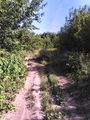
Dirt road leasing to hash
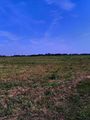
Free section of a field (you can see one with stuff further away)

On hash location
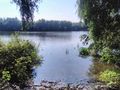
Moskva river
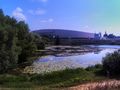
And Kolomenka river, together with local ice skating complex
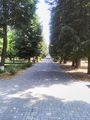
Local park, it's pretty nice
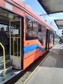
Tram that got me back to bus terminal


Achievements
Probably nothing I don't already own. Frankly, too many of those are just undoable in my area and/or alone.