Difference between revisions of "2021-07-23 60 24"
From Geohashing
(→Plan) |
(→Expedition) |
||
| Line 18: | Line 18: | ||
==Expedition== | ==Expedition== | ||
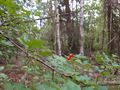
| − | The hashpoint was | + | The hashpoint was circa 15 km away from my home as the crow flies, but I made it 32 km to site, |
[[File:2021-07-23 60 24 05 Surroundings.jpg|1000px|Surroundings]] | [[File:2021-07-23 60 24 05 Surroundings.jpg|1000px|Surroundings]] | ||
Revision as of 14:59, 24 July 2021
| Fri 23 Jul 2021 in Helsinki: 60.2989105, 24.9365734 geohashing.info google osm bing/os kml crox |
Location
How convenient! This Geohash is located in the Virkamies district at Vantaa in the small park which carries name of Osumapuisto (Hit park).

Plan
PPP It'll be around 20 km cycling to north-northwest before the heat of the day reaches the max.

Expedition
The hashpoint was circa 15 km away from my home as the crow flies, but I made it 32 km to site,
- 2021-07-23 60 24 01 place.jpg
In the place
The site of the Geohash
Proof
- 2021-07-23 60 24 04 Geohash.jpg
The Geohash and my cycling shoes


Achievements
PPP earned the Land geohash achievement
|
PPP earned the Bicycle geohash achievement
|