Difference between revisions of "2021-08-04 48 16"
Gefrierbrand (talk | contribs) (→Location) |
m (per Renaming Proposal) |
||
| (5 intermediate revisions by 2 users not shown) | |||
| Line 1: | Line 1: | ||
| − | + | {{meetup graticule | |
| − | |||
| − | |||
| − | |||
| − | |||
| − | |||
| − | |||
| − | |||
| − | |||
| lat=48 | | lat=48 | ||
| lon=16 | | lon=16 | ||
| date=2021-08-04 | | date=2021-08-04 | ||
| − | }} | + | }} |
__NOTOC__ | __NOTOC__ | ||
== Location == | == Location == | ||
| Line 17: | Line 9: | ||
== Participants == | == Participants == | ||
| − | + | *[[User:Santu|Santu]] | |
| − | + | *[[User:Gefrierbrand|Gefrierbrand]] | |
| + | *Pedro the dog | ||
| + | |||
| + | == Expedition == | ||
| + | We were visiting relatives in Vienna and were happy that the hash was conveniently located within the city limits. It was also relatively near to our route we had to take anyway, but still meant a detour off at least an hour. So we just had to convince the others to either go along, or let us have the car. Since there was also shopping to be done, our group split up and Santu, Gefrierbrand and of course Pedro went on the geohashing adventure alone. | ||
| − | + | Getting in the general area was easy. Just as we wondered where we might be able to park, Santu suddenly spotted an nice place and quickly stopped about 500 m from the location. Walking the rest was relatively uneventful. We quickly reached the southern end of the small forest which contained the hash. It was very densely overgrown and covered in with branches, leaves, thorns and so on from pretty much every visible angle. The property to the west could potentially have given better access, but it was closed to the public. To the east there also were gardens and houses, but they also were private. So the only possible remaining path could be from the north. | |
| − | |||
| − | + | We walked around and tried from there: The vegetation was still very dense, but one opening was just big enough to get through and after the initial barrier it looked like the forest might open up a bit and be traversable. So we carefully climbed into the bushes. We had to carry Pedro over the first few branches as he was afraid to jump over them since he could not see what was behind. After that he managed on its own, but his leash often got very entangled. | |
| − | |||
| − | + | During this exiting adventure, we had to duck, jump, push and very often return a few meters to try from another angle a few meters to the side. In the end, we could get to about 30 m distance from the hash when the vegetation got so dense that there simply was no way (besides a machete perhaps) to continue in our nice clothes. Even though we were at one point within GPS accuracy and Geohashdroid had already turned green, we knew we weren't really there and therefore don't claim this has as reached – but we had fun and that's what counts. | |
| − | |||
== Photos == | == Photos == | ||
| − | |||
| − | |||
| − | |||
<gallery perrow="5"> | <gallery perrow="5"> | ||
| + | File:2021-08-04_48_16_ersteSeite.jpg | View where we first arrived from the south: no way to get through there. | ||
| + | File:2021-08-04_48_16_southtry.jpg | Only 40m to go, but are they possible? | ||
| + | File:2021-08-04_48_16_zweiteSeite.jpg| maybe more luck from the north? | ||
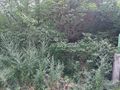
| + | File:2021-08-04_48_16_noway.jpg | Pedro and Santu in the bushes | ||
| + | File:2021-08-04_48_16_northtry.jpg | as close as we could get | ||
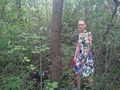
| + | File:2021-08-04_48_16_stupidgrin.jpg | StupidGrin<sup>TM</sup> is still required | ||
| + | |||
</gallery> | </gallery> | ||
== Achievements == | == Achievements == | ||
{{#vardefine:ribbonwidth|800px}} | {{#vardefine:ribbonwidth|800px}} | ||
| − | + | {{done with nature | |
| + | | latitude = 48 | ||
| + | | longitude = 16 | ||
| + | | date = 2021-08-04 | ||
| + | | excuse = But they got within 30 m | ||
| + | | name = Santu & Gefrierbrand | ||
| + | }} | ||
| − | |||
| − | |||
| − | |||
| − | |||
| − | |||
| − | |||
| − | |||
| − | |||
| − | |||
| − | |||
| − | |||
| − | |||
| − | |||
| − | |||
[[Category:Expeditions]] | [[Category:Expeditions]] | ||
| − | |||
[[Category:Expeditions with photos]] | [[Category:Expeditions with photos]] | ||
| − | |||
| − | |||
| − | |||
| − | |||
| − | |||
| − | |||
| − | |||
| − | |||
| − | |||
[[Category:Coordinates not reached]] | [[Category:Coordinates not reached]] | ||
| − | |||
| − | |||
[[Category:Not reached - Mother Nature]] | [[Category:Not reached - Mother Nature]] | ||
| − | + | [[Category:Expeditions with dogs]] | |
| − | + | {{location|AT|W}} | |
| − | [[Category: | ||
| − | |||
| − | |||
| − | |||
| − | |||
| − | |||
| − | |||
| − | |||
| − | |||
Latest revision as of 14:27, 2 April 2024
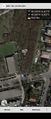
| Wed 4 Aug 2021 in 48,16: 48.2896042, 16.4214510 geohashing.info google osm bing/os kml crox |
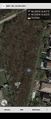
Location
In a dense forest next to a childcare in the northern outskirts of Vienna.
Participants
- Santu
- Gefrierbrand
- Pedro the dog
Expedition
We were visiting relatives in Vienna and were happy that the hash was conveniently located within the city limits. It was also relatively near to our route we had to take anyway, but still meant a detour off at least an hour. So we just had to convince the others to either go along, or let us have the car. Since there was also shopping to be done, our group split up and Santu, Gefrierbrand and of course Pedro went on the geohashing adventure alone.
Getting in the general area was easy. Just as we wondered where we might be able to park, Santu suddenly spotted an nice place and quickly stopped about 500 m from the location. Walking the rest was relatively uneventful. We quickly reached the southern end of the small forest which contained the hash. It was very densely overgrown and covered in with branches, leaves, thorns and so on from pretty much every visible angle. The property to the west could potentially have given better access, but it was closed to the public. To the east there also were gardens and houses, but they also were private. So the only possible remaining path could be from the north.
We walked around and tried from there: The vegetation was still very dense, but one opening was just big enough to get through and after the initial barrier it looked like the forest might open up a bit and be traversable. So we carefully climbed into the bushes. We had to carry Pedro over the first few branches as he was afraid to jump over them since he could not see what was behind. After that he managed on its own, but his leash often got very entangled.
During this exiting adventure, we had to duck, jump, push and very often return a few meters to try from another angle a few meters to the side. In the end, we could get to about 30 m distance from the hash when the vegetation got so dense that there simply was no way (besides a machete perhaps) to continue in our nice clothes. Even though we were at one point within GPS accuracy and Geohashdroid had already turned green, we knew we weren't really there and therefore don't claim this has as reached – but we had fun and that's what counts.
Photos
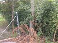
View where we first arrived from the south: no way to get through there.
Only 40m to go, but are they possible?
maybe more luck from the north?
Pedro and Santu in the bushes
as close as we could get

StupidGrinTM is still required


Achievements
Santu & Gefrierbrand earned the Done with Nature consolation prize
|