Difference between revisions of "2021-08-25 47 12"
Clearlucid9 (talk | contribs) m (→Photos) |
Clearlucid9 (talk | contribs) m (→Photos) |
||
| Line 20: | Line 20: | ||
File:2021-08-22 15.28.16.jpg | road towards the area of the hash | File:2021-08-22 15.28.16.jpg | road towards the area of the hash | ||
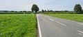
File:2021-08-25 14.34.11.jpg | alternative routes towards the hash | File:2021-08-25 14.34.11.jpg | alternative routes towards the hash | ||
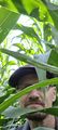
| − | File:2021-08-25 | + | File:2021-08-25 15.36.13.jpg | standing in front of the corn field |
| + | File:2021-08-25 16.28.42.jpg | | ||
File:2021-08-25 16.35.16.jpg | | File:2021-08-25 16.35.16.jpg | | ||
| − | |||
File:2021-08-25 16.25.35.jpg | | File:2021-08-25 16.25.35.jpg | | ||
| − | |||
File:2021-08-25 16.28.56.jpg | | File:2021-08-25 16.28.56.jpg | | ||
</gallery> | </gallery> | ||
Revision as of 19:21, 2 October 2021
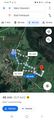
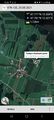
| Wed 19 May 2021 in Innsbruck: 47.0870125, 12.7448975 geohashing.info google osm bing/os kml crox |
Location
in a corn field just north of Wiechs
Participants
Expedition
I had to spend 3 weeks in the rehabilitation clinic outside of Bad Feilnbach, when one sunny afternoon I had some spare time and by coincidence the hash was in walking distance from the clinic. So I set out for a good walk, taking my drone with me. As I got a little hungry on my way, I picked a plum from a tree on the roadside. once I came close to the hash coordinates I realised that it was in the middle of a cornfield. I tried to get there, but it turned out to be way more difficult than it looked. After getting stuck between the dense rows of corn plants, I decided to return, always trying to avoid any damage to the plants... In the end I think I got within 80m of the hash coordinates. After that I had to take the long walk back, picking another plum from the same tree...
Photos
road towards the area of the hash
alternative routes towards the hash
standing in front of the corn field