Difference between revisions of "2021-08-26 53 9"
(expedition report) |
(→Photos) |
||
| Line 20: | Line 20: | ||
==Photos== | ==Photos== | ||
| − | + | [[File:20210826_204715.jpg|750px|Panorama at the geohash]] | |
| + | <gallery> | ||
| + | File:Screenshot_20210826-204630_Maps.jpg | proof | ||
| + | File:Screenshot_20210826-204654_Coordinates.jpg | coords | ||
| + | File:20210826_204424.jpg | earth or ant hill? | ||
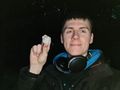
| + | File:20210826_204913.jpg | Baruch at the hash | ||
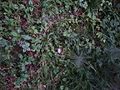
| + | File:20210826_204935.jpg | close-up | ||
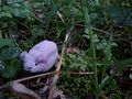
| + | File:20210826_205014.jpg | π π π | ||
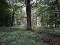
| + | File:20210826_204739.jpg | forest after dusk | ||
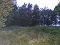
| + | File:20210826_204805.jpg | view toward the golf course | ||
| + | File:20210826_205655.jpg | so close to a golf hash! | ||
| + | </gallery> | ||
==Achievements== | ==Achievements== | ||
Latest revision as of 10:49, 3 July 2023
| Thu 26 Aug 2021 in 53,9: 53.7808346, 9.9529277 geohashing.info google osm bing/os kml crox |
Location
in a forest near Gut Kaden golf course in Alveslohe, Schleswig-Holstein
Participants
Plans
Two hashes less than 3 km from home in a row? That's a first!
Plan: cycle there from Ulzburg Süd station on the way back from the Observatory
Expedition
Leaving the Hamburg Observatory a little later than I expected, it was already very dark when I arrived at Ulzburg Süd station. From there, I cycled 2 km to the hashforest. According to OSM, a path existed that leads through the forest past the hash, but it turned out to only be a wide overgrown aisle with no signs of use. I used my phone's light to guide me and walked 220 m through the dark, wet undergrowth. I found the coordinates 25 m from the "path" and beside a clearing, only 2 m from what in the dark looked like a giant ant hill, but could've just been a pile of earth.
I spotted a bat against the sky, which is still exciting to me because I see them very rarely, and then took some photos of Baruch and me at highest sensitivity or with flash. Subsequently, I walked the 70 m to the nearby golf course. I couldn't reach the first tee off zone (or was it a green?) due to thick growth, but walked along the path for 80 more m to the next, which gave way to the fairway. It's great that you can just stroll onto golf courses without them being fenced off.
I walked back the path and then directly across the clearing to the street, from where I reached my bike and cycled the 2.7 km home. Apart from the two near misses of a Couch Potato honourable mention, this was the hash nearest to my home!
Photos

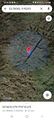
proof

coords
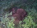
earth or ant hill?
Baruch at the hash
close-up
π π π
forest after dusk
view toward the golf course
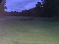
so close to a golf hash!


Achievements
Land geohash, Bicycle geohash, Public transport geohash