Difference between revisions of "2021-09-04 60 25"
([live picture]Rails next [https://openstreetmap.org/?mlat=60.33279600&mlon=25.06920600&zoom=16 @60.3328,25.0692]) |
(success - my first in Finland) |
||
| Line 19: | Line 19: | ||
== Expedition == | == Expedition == | ||
<!-- how it all turned out. your narrative goes here. --> | <!-- how it all turned out. your narrative goes here. --> | ||
| + | Other than a small amount of confusion about "zone extension" on the HSL app, everything went smoothly - the bus left promptly at 14:44. A number of other folks joined, talking excitedly about an adventure - but alas, they all got off at the same stop, half a kilometer short of Myyras. | ||
| + | |||
| + | I exited the bus and walked down the clearly marked road/path. Passed a few dog walkers and one cute puppy - sorry, no picture. This path eventually brought me to the next busy road to cross. Beyond that the trail was considerably less traveled. | ||
| + | |||
| + | I headed down this access road, unsure of how close to the field I could get. The overhead showed some trees - but I would not need to bushwack this time. The road led clearly down. At that point I found a convenient boulder and took a seat, in case somebody else was going to show up near 4. | ||
| + | |||
| + | Time expired, and nobody else did. I marched out into the field - harvested, but also full of some pretty big rocks. I reached 0.3m on the first attempt, then took a picture and came back to 1.8 meters. A geohash dance and a few pictures later and I settled for the Saturday public-transit completion. | ||
| + | |||
| + | Alas, I did not continue further west to see the river - though I did cross it later on. My original plan was to walk back to the bus and take it to the end of the route - a "K" train station I could take back to the city. The time on my zone extension expired, however, and it was a nice enough day. I decided to walk for 45 minutes to the train station instead. | ||
| + | |||
| + | I followed the map suggestion and backtracked to the second road, then south, then west. Interestingly, this new path I was on turned right past the field I was in. Had I known, I could have continued south (and slightly west) from the hashpoint to reach this spot. | ||
| + | |||
| + | The road and path combination led past several houses, with Saturday projects in progress, and also over the river and through the woods. Eventually I reached the train station. My final planned stop was Bierhaus Koln, a German-inspired pub in Helsinki, where I had an English beer and listened to a Seattle band. | ||
| + | |||
| + | Small world indeed! | ||
== Tracklog == | == Tracklog == | ||
| Line 44: | Line 59: | ||
Image:2021-09-04_60_25_thomcat_1630763612000.jpg|Rails next [https://openstreetmap.org/?mlat=60.33279600&mlon=25.06920600&zoom=16 @60.3328,25.0692] | Image:2021-09-04_60_25_thomcat_1630763612000.jpg|Rails next [https://openstreetmap.org/?mlat=60.33279600&mlon=25.06920600&zoom=16 @60.3328,25.0692] | ||
| + | |||
| + | Image:2021-09-04 60 25 thomcat 1630765082000.jpg|You have arrived at your destination :) | ||
</gallery> | </gallery> | ||
| Line 52: | Line 69: | ||
--> | --> | ||
| − | |||
| − | |||
| − | |||
[[Category:Expeditions]] | [[Category:Expeditions]] | ||
[[Category:Expeditions with photos]] | [[Category:Expeditions with photos]] | ||
[[Category:Coordinates reached]] | [[Category:Coordinates reached]] | ||
| − | |||
| − | |||
| − | |||
| − | |||
| − | |||
| − | |||
| − | |||
| − | |||
| − | |||
| − | |||
| − | |||
{{location|FI|18}} | {{location|FI|18}} | ||
Latest revision as of 17:48, 4 September 2021
| Sat 4 Sep 2021 in Vantaa: 60.3326847, 25.1209803 geohashing.info google osm bing/os kml crox |
Location
Farmland near the Keravanjoki in Sipoo
Participants
Plans
Leave Rautatientori on the 739 at 14:44; get off at Myyras then walk to the geohash. Will wait until after 4, then return to Myyras head towards Bierhaus Köln for a pint.
Expedition
Other than a small amount of confusion about "zone extension" on the HSL app, everything went smoothly - the bus left promptly at 14:44. A number of other folks joined, talking excitedly about an adventure - but alas, they all got off at the same stop, half a kilometer short of Myyras.
I exited the bus and walked down the clearly marked road/path. Passed a few dog walkers and one cute puppy - sorry, no picture. This path eventually brought me to the next busy road to cross. Beyond that the trail was considerably less traveled.
I headed down this access road, unsure of how close to the field I could get. The overhead showed some trees - but I would not need to bushwack this time. The road led clearly down. At that point I found a convenient boulder and took a seat, in case somebody else was going to show up near 4.
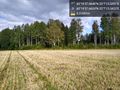
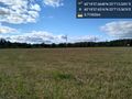
Time expired, and nobody else did. I marched out into the field - harvested, but also full of some pretty big rocks. I reached 0.3m on the first attempt, then took a picture and came back to 1.8 meters. A geohash dance and a few pictures later and I settled for the Saturday public-transit completion.
Alas, I did not continue further west to see the river - though I did cross it later on. My original plan was to walk back to the bus and take it to the end of the route - a "K" train station I could take back to the city. The time on my zone extension expired, however, and it was a nice enough day. I decided to walk for 45 minutes to the train station instead.
I followed the map suggestion and backtracked to the second road, then south, then west. Interestingly, this new path I was on turned right past the field I was in. Had I known, I could have continued south (and slightly west) from the hashpoint to reach this spot.
The road and path combination led past several houses, with Saturday projects in progress, and also over the river and through the woods. Eventually I reached the train station. My final planned stop was Bierhaus Koln, a German-inspired pub in Helsinki, where I had an English beer and listened to a Seattle band.
Small world indeed!
Tracklog
Photos
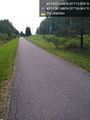
Walk/bicycle trail @60.3328,25.1245
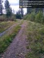
Trail leading down to the field @60.3331,25.1244
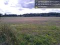
The field @60.3329,25.1220
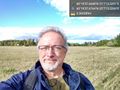
Geohasher - outstanding in the field @60.3327,25.1210
Looking back towards road @60.3327,25.1210
To the west, a highway @60.3327,25.1210
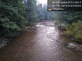
River @60.3283,25.0914
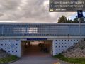
Rails next @60.3328,25.0692
You have arrived at your destination :)


