Difference between revisions of "2021-09-11 49 35"
From Geohashing
(→Photos) |
|||
| Line 1: | Line 1: | ||
| − | + | [[Image:{{{image|IMG 20210911 180022.jpg}}}|thumb|left]] | |
| − | + | {{meetup graticule | |
| − | |||
| − | |||
| − | |||
| − | |||
| − | |||
| − | |||
| lat=49 | | lat=49 | ||
| lon=35 | | lon=35 | ||
| Line 14: | Line 8: | ||
__NOTOC__ | __NOTOC__ | ||
== Location == | == Location == | ||
| − | + | In a field. | |
== Participants == | == Participants == | ||
| − | + | [[User:Nope|Nope]] ([[User talk:Nope|talk]]) | |
| − | |||
== Plans == | == Plans == | ||
| − | + | Just reach the location. | |
== Expedition == | == Expedition == | ||
| − | + | As I was getting closer to the location, I was surrounded by fields that were mostly harvested. I really hoped that the field the geohash was located in would be empty as well or at least planted with something that was not corn or sunflower. Surprisingly<ref>[https://en.wikipedia.org/wiki/Sunflower_seed#Production In 2018, global production of sunflower seeds was 52 million tonnes, led by Ukraine with 27%.]</ref> the field was filled with dying sunflowers. But why would some plants that are taller than me stop me? | |
| − | |||
| − | |||
| − | |||
| − | |||
== Photos == | == Photos == | ||
<gallery perrow="5"> | <gallery perrow="5"> | ||
| − | Image:IMG 20210911 175314.jpg | | + | Image:IMG 20210911 175314.jpg | Someone has planted spruces(?) on the edge of the field |
| − | Image:IMG 20210911 180022.jpg | | + | Image:IMG 20210911 180022.jpg | Sunflowers sticking from the ground, where the geohash is located |
| − | Image:IMG 20210911 180038.jpg | | + | Image:IMG 20210911 180038.jpg | More sunflowers |
Image:IMG 20210912 231809.jpg | | Image:IMG 20210912 231809.jpg | | ||
Image:IMG 20210912 231728.jpg | | Image:IMG 20210912 231728.jpg | | ||
| Line 39: | Line 28: | ||
== Achievements == | == Achievements == | ||
| − | |||
| − | |||
| − | + | [[Multihash|Double Hash]] was close (as I visited [[2021-09-11 49 36]] the same day) but the exact conditions were not met. | |
| − | |||
| − | |||
| − | |||
| − | |||
| − | |||
| − | |||
| − | |||
| − | |||
| − | |||
| − | |||
| − | |||
| − | |||
[[Category:Expeditions]] | [[Category:Expeditions]] | ||
| − | |||
[[Category:Expeditions with photos]] | [[Category:Expeditions with photos]] | ||
| − | |||
| − | |||
| − | |||
| − | |||
| − | |||
[[Category:Coordinates reached]] | [[Category:Coordinates reached]] | ||
| − | |||
| − | |||
| − | |||
| − | |||
| − | |||
| − | |||
| − | |||
| − | |||
| − | |||
| − | |||
| − | |||
| − | |||
| − | |||
| − | |||
| − | |||
| − | |||
| − | |||
| − | |||
Revision as of 22:28, 12 September 2021

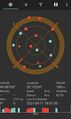
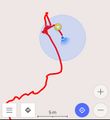
| Sat 11 Sep 2021 in 49,35: 49.8876195, 35.1233311 geohashing.info google osm bing/os kml crox |
Location
In a field.
Participants
Plans
Just reach the location.
Expedition
As I was getting closer to the location, I was surrounded by fields that were mostly harvested. I really hoped that the field the geohash was located in would be empty as well or at least planted with something that was not corn or sunflower. Surprisingly[1] the field was filled with dying sunflowers. But why would some plants that are taller than me stop me?
Photos
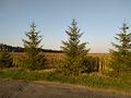
Someone has planted spruces(?) on the edge of the field
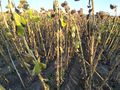
Sunflowers sticking from the ground, where the geohash is located
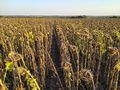
More sunflowers


Achievements
Double Hash was close (as I visited 2021-09-11 49 36 the same day) but the exact conditions were not met.