Difference between revisions of "2021-10-01 48 8"
From Geohashing
([live picture]Cycle to the hash point above Ebhausen) |
m (Location) |
||
| (4 intermediate revisions by 2 users not shown) | |||
| Line 15: | Line 15: | ||
== Location == | == Location == | ||
<!-- where you've surveyed the hash to be --> | <!-- where you've surveyed the hash to be --> | ||
| + | Field on a hill overlooking Ebhausen | ||
== Participants == | == Participants == | ||
<!-- who attended: If you link to your wiki user name in this section, your expedition will be picked up by the various statistics generated for geohashing. You may use three tildes ~ as a shortcut to automatically insert the user signature of the account you are editing with. | <!-- who attended: If you link to your wiki user name in this section, your expedition will be picked up by the various statistics generated for geohashing. You may use three tildes ~ as a shortcut to automatically insert the user signature of the account you are editing with. | ||
--> | --> | ||
| − | + | [[User:Fenn|Fenn]] ([[User talk:Fenn|talk]]) | |
| − | |||
| − | |||
== Expedition == | == Expedition == | ||
<!-- how it all turned out. your narrative goes here. --> | <!-- how it all turned out. your narrative goes here. --> | ||
| + | Fenn cycled along the Nagold river. There were a lot of insects in the air today. In Ebhausen a challenging uphill section was waiting. The hash was not reachable without stepping into a field, but Fenn got off the bike and walked around it to find the closest point. It offered an excellent view of Ebhausen in the glistening light of the setting sun. Fenn made his way home via the sleepy village of Pfrondorf, but not without picking up a few red apples from the surrounding orchards. | ||
== Tracklog == | == Tracklog == | ||
<!-- if your GPS device keeps a log, you may use Template:Tracklog, post a link here, or both --> | <!-- if your GPS device keeps a log, you may use Template:Tracklog, post a link here, or both --> | ||
| + | <gallery perrow="5"> | ||
| + | |||
| + | File:Screenshot_2021-10-01-18-44-40.png|GPS log 66m off | ||
| + | </gallery> | ||
== Photos == | == Photos == | ||
<!-- Insert pictures between the gallery tags using the following format: | <!-- Insert pictures between the gallery tags using the following format: | ||
| Line 35: | Line 39: | ||
<gallery perrow="5"> | <gallery perrow="5"> | ||
| − | Image:2021-10-01_48_8_Fenn_1633112994343.jpg| | + | Image:2021-10-01_48_8_Fenn_1633112994343.jpg|Hash point is in the middle of this field |
| + | |||
</gallery> | </gallery> | ||
| Line 42: | Line 47: | ||
<!-- Add any achievement ribbons you earned below, or remove this section --> | <!-- Add any achievement ribbons you earned below, or remove this section --> | ||
| − | |||
| − | |||
| − | |||
| − | |||
| − | |||
| − | |||
| − | |||
| − | |||
| − | |||
| − | |||
| − | |||
| − | |||
| − | |||
| − | |||
[[Category:Expeditions]] | [[Category:Expeditions]] | ||
| − | |||
[[Category:Expeditions with photos]] | [[Category:Expeditions with photos]] | ||
| − | |||
| − | |||
| − | |||
| − | |||
| − | |||
| − | |||
| − | |||
| − | |||
| − | |||
[[Category:Coordinates not reached]] | [[Category:Coordinates not reached]] | ||
| − | |||
| − | |||
| − | |||
| − | |||
| − | |||
[[Category:Not reached - No public access]] | [[Category:Not reached - No public access]] | ||
| − | + | {{location|DE|BW|CW}} | |
| − | |||
| − | |||
| − | |||
| − | |||
| − | |||
| − | |||
| − | |||
Latest revision as of 13:43, 2 October 2021
| Fri 1 Oct 2021 in 48,8: 48.5887013, 8.6848535 geohashing.info google osm bing/os kml crox |
Location
Field on a hill overlooking Ebhausen
Participants
Expedition
Fenn cycled along the Nagold river. There were a lot of insects in the air today. In Ebhausen a challenging uphill section was waiting. The hash was not reachable without stepping into a field, but Fenn got off the bike and walked around it to find the closest point. It offered an excellent view of Ebhausen in the glistening light of the setting sun. Fenn made his way home via the sleepy village of Pfrondorf, but not without picking up a few red apples from the surrounding orchards.
Tracklog
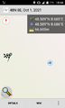
GPS log 66m off

Photos
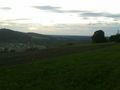
Hash point is in the middle of this field
