Difference between revisions of "2021-10-02 51 9"
(→Plans) |
|||
| Line 20: | Line 20: | ||
== Expedition == | == Expedition == | ||
<!-- how it all turned out. your narrative goes here. --> | <!-- how it all turned out. your narrative goes here. --> | ||
| − | --- | + | Today was a good day for some walking in the woods, so I decided to go for the hash as well as some geocaches and left home at around 9:30 am - and arrived in the Reinhardswald some 75 minutes later. I parked my car, had a little breakfast and started with the geohash. Well, the terrain wasn't that steep as expected, but, the entire area seemed to be locked behind a fence. I walked around this wooded area, but all I saw was this fence - oh, does it mean that todays hash is unreachable? |
| + | |||
| + | Before even thinking about giving up, I came to a gate some minutes later and indeed, I could enter the area. Sort of silly... After finding the correct way to the hash, I somehow had to go through another gate - which didn't make sense, but I didn't bother, since the geohash was in reach now! After walking a few hundred meters, I approached the hash, and had to go off the path for only some 50 meters. The terrain was ok - sort of sandy with pretty big holes in it, so I had to be carefull, but reached the hash some minutes later... | ||
| + | |||
| + | Nothing spectacular to see here, some trees and one of them was the hash - I took some pics for proof and got as near as 0,312 meters haha - quite accurate this time! After doing the hash I went on for a nice walk through the Reinhardswald, found some 30 geocaches and had a hike of little over 15 kilometers in 4 hours. At around 4 pm I was home again and celebrated todays succesfull expedition! | ||
== Photos == | == Photos == | ||
| − | < | + | <gallery> |
| − | Image: | + | Image:2021-10-02_51_9_001.jpg|On my way to the hash |
| − | + | Image:2021-10-02_51_9_002.jpg|The fence | |
| − | Image:2021- | + | Image:2021-10-02_51_9_003.jpg|The first gate |
| − | Image:2021- | + | Image:2021-10-02_51_9_004.jpg|The way to the hash |
| − | Image:2021- | + | Image:2021-10-02_51_9_005.jpg|Another gate I had to pass |
| − | Image:2021- | + | Image:2021-10-02_51_9_006.jpg|The path leading to the hash |
| + | Image:2021-10-02_51_9_007.jpg|The hasher at the hash location | ||
| + | Image:2021-10-02_51_9_008.jpg|View the hash | ||
| + | Image:2021-10-02_51_9_009.jpg|This fence - again, but a nice view from here | ||
| + | Image:2021-10-02_51_9_010.jpg|Proof | ||
</gallery> | </gallery> | ||
| − | |||
[[Category:Expeditions]] | [[Category:Expeditions]] | ||
| − | |||
[[Category:Expeditions with photos]] | [[Category:Expeditions with photos]] | ||
[[Category:Coordinates reached]] | [[Category:Coordinates reached]] | ||
| − | |||
{{location|DE|HE|KS}} | {{location|DE|HE|KS}} | ||
Latest revision as of 17:23, 2 October 2021
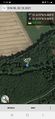
| Sat 2 Oct 2021 in 51,9: 51.6187212, 9.4692477 geohashing.info google osm bing/os kml crox |
Location
In a forest south of Helmarshausen
Participants
Plans
Drive to Helmarshausen by car and go for this hash in the forest... Seems to be steep terrain to the hash, but I will find out more about it tomorrow... There's some geocaches as well here, so I will combine my tour with seeking some geocaches as well...
Expedition
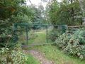
Today was a good day for some walking in the woods, so I decided to go for the hash as well as some geocaches and left home at around 9:30 am - and arrived in the Reinhardswald some 75 minutes later. I parked my car, had a little breakfast and started with the geohash. Well, the terrain wasn't that steep as expected, but, the entire area seemed to be locked behind a fence. I walked around this wooded area, but all I saw was this fence - oh, does it mean that todays hash is unreachable?
Before even thinking about giving up, I came to a gate some minutes later and indeed, I could enter the area. Sort of silly... After finding the correct way to the hash, I somehow had to go through another gate - which didn't make sense, but I didn't bother, since the geohash was in reach now! After walking a few hundred meters, I approached the hash, and had to go off the path for only some 50 meters. The terrain was ok - sort of sandy with pretty big holes in it, so I had to be carefull, but reached the hash some minutes later...
Nothing spectacular to see here, some trees and one of them was the hash - I took some pics for proof and got as near as 0,312 meters haha - quite accurate this time! After doing the hash I went on for a nice walk through the Reinhardswald, found some 30 geocaches and had a hike of little over 15 kilometers in 4 hours. At around 4 pm I was home again and celebrated todays succesfull expedition!
Photos
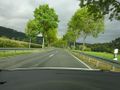
On my way to the hash
The fence
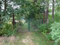
The first gate
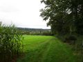
The way to the hash
Another gate I had to pass
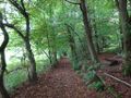
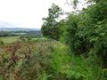
The path leading to the hash

The hasher at the hash location
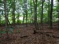
View the hash
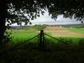
This fence - again, but a nice view from here
Proof


