Difference between revisions of "2021-10-16 51 9"
(Created page with "{{meetup graticule | lat=51 | lon=9 | date=2021-10-16 }} __NOTOC__ == Location == In a forest east of Lippoldshausen == Participants == Digiphono == Pl...") |
|||
| Line 21: | Line 21: | ||
== Expedition == | == Expedition == | ||
<!-- how it all turned out. your narrative goes here. --> | <!-- how it all turned out. your narrative goes here. --> | ||
| + | I drove to Lippoldshausen and parked my car at the local sports area and did a nice walk from there. As usual, I went for some geocaches as well, and I made a side trip to the hash, which leds me into a forest that was ''officially'' closed - due to the risk of branches falling down and causing injuries. Hm, with stormy weather I normally respect such warnings, but today I didn't see any risk at all, so I entered the forest and climbed this little hill to get to the hash... | ||
| + | |||
| + | The terrain was pretty steep to both sides of the path that I was following and I already throught that I could have bad luck to reach the exact coordinates, but some 40 meters from the hash, where the path suddenly ended, I noticed that things turned out to be quite ''comfortable'' - which meant climbing only a few meters and reaching the hash location without any effort at all. So, I'd say this was another easy one in the end! | ||
| + | |||
| + | After making some pics for proof I walked down the hill and continued my walk around the village of Lippoldshausen. | ||
== Photos == | == Photos == | ||
| + | <gallery> | ||
| + | Image:2021-10-16_51_9_001.jpg|On my way to the hash | ||
| + | Image:2021-10-16_51_9_002.jpg|Entering the forest was forbidden | ||
| + | Image:2021-10-16_51_9_003.jpg|Pretty steep terrain | ||
| + | Image:2021-10-16_51_9_004.jpg|Some 40 meters to go to the left from here | ||
| + | Image:2021-10-16_51_9_005.jpg|End of the path | ||
| + | Image:2021-10-16_51_9_006.jpg|Near the hash | ||
| + | Image:2021-10-16_51_9_007.jpg|The hash was this tree trunk | ||
| + | Image:2021-10-16_51_9_008.jpg|The hasher at the hash location | ||
| + | Image:2021-10-16_51_9_009.jpg|Nice view from the hash | ||
| + | Image:2021-10-16_51_9_010.jpg|Proof | ||
| + | </gallery> | ||
| + | |||
| + | [[Category:Expeditions]] | ||
| + | [[Category:Expeditions with photos]] | ||
| + | [[Category:Coordinates reached]] | ||
| + | {{location|DE|NI|GÖ}} | ||
Revision as of 15:10, 16 October 2021
| Sat 16 Oct 2021 in 51,9: 51.4137404, 9.7530277 geohashing.info google osm bing/os kml crox |
Location
In a forest east of Lippoldshausen
Participants
Plans
Drive to Lippoldshausen and go for the hash - doing another walk in Hann. Münden after visiting the hash.
This one simply is too good for me - otherwise I might have catched up with Fippe and GeorgDerReisende on their meet up in Hannover - looking forward to meet you some other time then!
Expedition
I drove to Lippoldshausen and parked my car at the local sports area and did a nice walk from there. As usual, I went for some geocaches as well, and I made a side trip to the hash, which leds me into a forest that was officially closed - due to the risk of branches falling down and causing injuries. Hm, with stormy weather I normally respect such warnings, but today I didn't see any risk at all, so I entered the forest and climbed this little hill to get to the hash...
The terrain was pretty steep to both sides of the path that I was following and I already throught that I could have bad luck to reach the exact coordinates, but some 40 meters from the hash, where the path suddenly ended, I noticed that things turned out to be quite comfortable - which meant climbing only a few meters and reaching the hash location without any effort at all. So, I'd say this was another easy one in the end!
After making some pics for proof I walked down the hill and continued my walk around the village of Lippoldshausen.
Photos
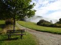
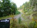
On my way to the hash
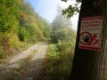
Entering the forest was forbidden
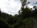
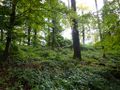
Pretty steep terrain
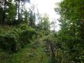
Some 40 meters to go to the left from here
End of the path
Near the hash
The hash was this tree trunk

The hasher at the hash location
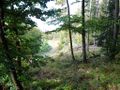
Nice view from the hash
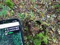
Proof


