Difference between revisions of "2021-10-25 42 -83"
(→Achievements) |
|||
| Line 54: | Line 54: | ||
}} | }} | ||
| − | |||
| − | |||
| − | |||
| − | |||
| − | |||
| − | |||
| − | |||
| − | |||
| − | |||
| − | |||
| − | |||
| − | |||
| − | |||
| − | |||
[[Category:Expeditions]] | [[Category:Expeditions]] | ||
| − | + | [[Category:Expeditions with photos]] | |
| − | [[Category:Expeditions with photos]] | ||
| − | |||
| − | |||
| − | |||
| − | |||
| − | |||
[[Category:Coordinates reached]] | [[Category:Coordinates reached]] | ||
| − | |||
| − | |||
| − | |||
| − | |||
| − | |||
| − | |||
| − | |||
| − | |||
| − | |||
| − | |||
| − | |||
| − | |||
| − | |||
| − | |||
| − | |||
| − | |||
| − | |||
| − | |||
Revision as of 01:39, 26 October 2021
| Mon 25 Oct 2021 in 42,-83: 42.2872584, -83.7387920 geohashing.info google osm bing/os kml crox |
Location
Along the Border to Border Trail, a non-motorized trail in Ann Arbor, Michigan. Today's hashpoint is about 43 metres west of the westernmost point of Ann Arbor's Riverside Park.
Participants
Plans
I (Alison) am attempting to puppet master today's hash by directing my friend Jacob (who lives in Ann Arbor) to visit the hashpoint. I have to work and visit a tailor today, so I probably won't have time to visit it myself.
I messaged Jacob on Discord around 11:10 EDT this morning, and he agreed to visit the hashpoint later today and provide proof.
Expedition
Jacob visited the hashpoint around 21:00 tonight and provided me geotagged photos as proof. On his way back to the car, he saw a heron, which he also photographed.
I ended up visiting a hobby shop and buying scale modelling tools (a paint work stand, a hand-operated drill, and masking tape) instead of visiting a tailor, because I forgot to wear the right bra for the dress I need altered.
Tracklog
Photos

Jacob’s selfie at the hashpoint.
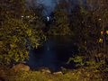
View of the Huron River from the hashpoint.
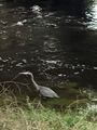
A heron that Jacob encountered while walking back to his car.


Achievements
Alison earned the Puppet Master Geohash achievement
|