Difference between revisions of "2021-11-05 49 8"
Gefrierbrand (talk | contribs) ([retro picture]Bismarcksturm) |
Gefrierbrand (talk | contribs) |
||
| (5 intermediate revisions by 3 users not shown) | |||
| Line 14: | Line 14: | ||
== Expedition == | == Expedition == | ||
| − | + | We noticed that the hashlocation was about half an hour away from us in the [https://www.geo-naturpark.net/en/ Geopark Odenwald] and we started to look for interesting stuff in the area to visit. A few quick searches revealed several POIs and we decided to go on Pedros evening walk slightly away from home. | |
| + | As it was already dusk, we decided to first go to the viewpoints before starting to locate the hashpoint. We began by walking uphill on a slippery path towards the Bismarkturm and proceeded to climb on it. Despite huge clouds and impending darkness, we had a good view from there on our next stop, Castle Lindenfels. | ||
| + | |||
| + | Once we found a parkingspot in the center of the town, we stumbled upon another tower – the Bürgerturm – and since it was open we had to climb it, too. Inside was a steep spiral staircase and alongside it on the wall some interesting automatically illuminated historical drawings of dragons. We had accidentally discovered part of the [http://www.deutsches-drachenmuseum.de/ German Dragonmuseum]. | ||
| + | |||
| + | After that we split up and took two different routes towards the central ruin of Castle Lindenfels since Pedro was sadly not allowed in the herb garden. Back together we explored the ruins for a bit (now already in the dark) and continued to go to the hash after Santu got pretend-stuck in the opening of a large tree trunk. | ||
| + | |||
| + | We found another parking spot near a cowshed with adorable calves and walked from there in almost complete darkness. Fortunately the hashlocation was easily accessible and not too far of a dirt road next to the edge of the forest. We took the obligatory pictures and headed back home again. | ||
== Photos == | == Photos == | ||
| Line 22: | Line 29: | ||
--> | --> | ||
<gallery perrow="5"> | <gallery perrow="5"> | ||
| − | + | Image:2021-11-05_49_8_Gefrierbrand_1636227424926.jpg|Lindwurm | |
| + | Image:2021-11-05_49_8_Gefrierbrand_1636227396080.jpg|Bismarckturm | ||
| + | Image:2021-11-05_49_8_Gefrierbrand_1636227355867.jpg|on top of the Bürgerturm | ||
| + | Image:2021-11-05_49_8_Gefrierbrand_1636227257158.jpg|Lindenfels | ||
| + | Image:2021-11-05_49_8_Gefrierbrand_1636227229645.jpg|Treehole | ||
| + | Image:2021-11-05_49_8_Gefrierbrand_1636227292663.jpg|spooky birdfeeder | ||
| + | Image:2021-11-05_49_8_Gefrierbrand_1636227159193.jpg|Santu&Pedro in the dark | ||
| + | Image:2021-11-05_49_8_Gefrierbrand_1636227496183.jpg|Gefrierbrand in the dark | ||
| + | Image:2021-11-05_49_8_Gefrierbrand_1636227125267.jpg|Stupid Grin | ||
Image:2021-11-05_49_8_Gefrierbrand_1636226728329.jpg|Proof | Image:2021-11-05_49_8_Gefrierbrand_1636226728329.jpg|Proof | ||
| − | |||
| − | |||
| − | |||
| − | |||
| − | |||
| − | |||
| − | |||
| − | |||
| − | |||
| − | |||
| − | |||
| − | |||
| − | |||
| − | |||
</gallery> | </gallery> | ||
== Achievements == | == Achievements == | ||
{{#vardefine:ribbonwidth|800px}} | {{#vardefine:ribbonwidth|800px}} | ||
| − | + | {{land geohash | |
| − | + | | latitude = 49 | |
| − | + | | longitude = 8 | |
| − | + | | date = 2021-11-05 | |
| − | + | | name = Gefrierbrand & Santu | |
| − | + | }} | |
| − | |||
| − | |||
| − | |||
| − | |||
| − | |||
| − | |||
| − | |||
| − | |||
| − | |||
| − | |||
[[Category:Expeditions]] | [[Category:Expeditions]] | ||
| − | |||
[[Category:Expeditions with photos]] | [[Category:Expeditions with photos]] | ||
| − | |||
| − | |||
| − | |||
| − | |||
| − | |||
[[Category:Coordinates reached]] | [[Category:Coordinates reached]] | ||
| − | + | [[Category:Expeditions with dogs]] | |
| − | + | {{location|DE|HE|ERB}} | |
| − | |||
| − | |||
| − | |||
| − | |||
| − | |||
| − | |||
| − | |||
| − | |||
| − | |||
| − | |||
| − | [[Category: | ||
| − | |||
| − | |||
| − | |||
| − | |||
| − | |||
Latest revision as of 07:57, 18 October 2022
| Fri 5 Nov 2021 in 49,8: 49.6894176, 8.8003866 geohashing.info google osm bing/os kml crox |
Location
On the edge of a forest near Lindenfels
Participants
- Santu
- Gefrierbrand
- Pedro the dog
Expedition
We noticed that the hashlocation was about half an hour away from us in the Geopark Odenwald and we started to look for interesting stuff in the area to visit. A few quick searches revealed several POIs and we decided to go on Pedros evening walk slightly away from home.
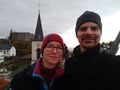
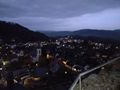
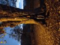
As it was already dusk, we decided to first go to the viewpoints before starting to locate the hashpoint. We began by walking uphill on a slippery path towards the Bismarkturm and proceeded to climb on it. Despite huge clouds and impending darkness, we had a good view from there on our next stop, Castle Lindenfels.
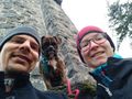
Once we found a parkingspot in the center of the town, we stumbled upon another tower – the Bürgerturm – and since it was open we had to climb it, too. Inside was a steep spiral staircase and alongside it on the wall some interesting automatically illuminated historical drawings of dragons. We had accidentally discovered part of the German Dragonmuseum.
After that we split up and took two different routes towards the central ruin of Castle Lindenfels since Pedro was sadly not allowed in the herb garden. Back together we explored the ruins for a bit (now already in the dark) and continued to go to the hash after Santu got pretend-stuck in the opening of a large tree trunk.
We found another parking spot near a cowshed with adorable calves and walked from there in almost complete darkness. Fortunately the hashlocation was easily accessible and not too far of a dirt road next to the edge of the forest. We took the obligatory pictures and headed back home again.
Photos
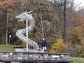
Lindwurm
Bismarckturm
on top of the Bürgerturm
Lindenfels
Treehole
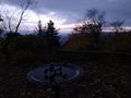
spooky birdfeeder
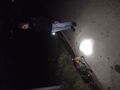
Santu&Pedro in the dark
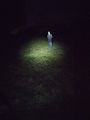
Gefrierbrand in the dark
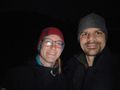
Stupid Grin
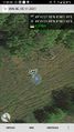
Proof


Achievements
Gefrierbrand & Santu earned the Land geohash achievement
|