Difference between revisions of "2021-11-13 51 9"
(Created page with "{{meetup graticule | lat=51 | lon=9 | date=2021-11-13 }} <!-- edit as necessary --> __NOTOC__ == Location == In a forest south of Ziegenhagen == Participants == User:Dig...") |
|||
| Line 20: | Line 20: | ||
== Expedition == | == Expedition == | ||
<!-- how it all turned out. your narrative goes here. --> | <!-- how it all turned out. your narrative goes here. --> | ||
| + | Such are the geohashes that I like most: doing a medium hike (7,5 km today) with a demanding altitude (200 meters today), getting to a place in the middle of nowhere actually, search for the hash and enjoy nature and silence... | ||
| + | |||
| + | I parked my car in Ziegenhagen and walked to the hash from there. Knew this area from previous tours, mainly because of finding some geocaches here in the past. This time I had to go another way to reach the hash. | ||
| + | |||
| + | On my way, I found this sign, warning for a hunt today - but I didn't hear any gun shootings and besides, all the deerstands I passed were empty - no hunt today it seems, so I was lucky! | ||
| + | |||
| + | The terrain was pretty steep on the last few meters and no actual path was leading to the hash. So, I had to climb and climb and reached the hash finally. It wasn't easy to locate the hash - but in the end I had a good accuracy of some three meters, made some pics for proof and got on my way back to my car. | ||
| + | |||
| + | Nothing more to tell about today... Tomorrow there's another hash in my homezone - I'm looking forward to that one already! | ||
| + | |||
| + | == Track == | ||
| + | <gallery> | ||
| + | Image:tracklog_2021-11-13_51_9.png|Todays track to the hash | ||
| + | </gallery> | ||
| − | |||
== Photos == | == Photos == | ||
<gallery> | <gallery> | ||
Image:2021-11-13_51_9_001.jpg|On my way to the hash | Image:2021-11-13_51_9_001.jpg|On my way to the hash | ||
| − | Image:2021-11-13_51_9_002.jpg|The hash was in the | + | Image:2021-11-13_51_9_002.jpg|Some donkeys, full of curiosity |
| − | Image:2021-11- | + | Image:2021-11-13_51_9_003.jpg|The hash was on the mountain in the background |
| − | Image:2021-11- | + | Image:2021-11-13_51_9_004.jpg|The sign warning for a hunt |
| − | Image:2021-11- | + | Image:2021-11-13_51_9_005.jpg|A really nice forest |
| − | Image:2021-11- | + | Image:2021-11-13_51_9_006.jpg|I had to get up here, to the deerstand |
| − | Image:2021-11- | + | Image:2021-11-13_51_9_007.jpg|From here, 407 m above sealevel, only 70 meters to the hash |
| − | Image:2021-11- | + | Image:2021-11-13_51_9_008.jpg|The hash |
| + | Image:2021-11-13_51_9_009.jpg|The hasher at the hash location | ||
| + | Image:2021-11-13_51_9_010.jpg|Hash surroundings | ||
| + | Image:2021-11-13_51_9_011.jpg|Hash surroundings | ||
| + | Image:2021-11-13_51_9_012.jpg|Proof | ||
</gallery> | </gallery> | ||
| Line 37: | Line 54: | ||
[[Category:Expeditions with photos]] | [[Category:Expeditions with photos]] | ||
[[Category:Coordinates reached]] | [[Category:Coordinates reached]] | ||
| − | {{location|DE|HE| | + | {{location|DE|HE|WIZ}} |
| − | |||
Latest revision as of 15:42, 13 November 2021
| Sat 13 Nov 2021 in 51,9: 51.3439570, 9.7435236 geohashing.info google osm bing/os kml crox |
Location
In a forest south of Ziegenhagen
Participants
Plans
Drive to Ziegenhagen by car and do a walk through the forest... The geohash seems to be in the middle of nowhere, so I am excited what challenge is waiting for me!
Expedition
Such are the geohashes that I like most: doing a medium hike (7,5 km today) with a demanding altitude (200 meters today), getting to a place in the middle of nowhere actually, search for the hash and enjoy nature and silence...
I parked my car in Ziegenhagen and walked to the hash from there. Knew this area from previous tours, mainly because of finding some geocaches here in the past. This time I had to go another way to reach the hash.
On my way, I found this sign, warning for a hunt today - but I didn't hear any gun shootings and besides, all the deerstands I passed were empty - no hunt today it seems, so I was lucky!
The terrain was pretty steep on the last few meters and no actual path was leading to the hash. So, I had to climb and climb and reached the hash finally. It wasn't easy to locate the hash - but in the end I had a good accuracy of some three meters, made some pics for proof and got on my way back to my car.
Nothing more to tell about today... Tomorrow there's another hash in my homezone - I'm looking forward to that one already!
Track
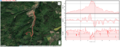
Todays track to the hash
Photos
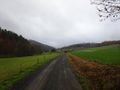
On my way to the hash
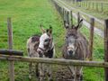
Some donkeys, full of curiosity
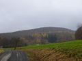
The hash was on the mountain in the background
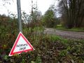
The sign warning for a hunt
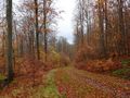
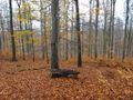
A really nice forest
I had to get up here, to the deerstand
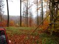
From here, 407 m above sealevel, only 70 meters to the hash
The hash

The hasher at the hash location
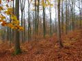
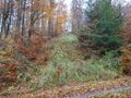
Hash surroundings
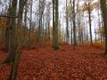
Hash surroundings

Proof


