Difference between revisions of "2021-11-13 52 5"
FelixTheCat (talk | contribs) (Created page with "{{subst:Expedition |lat = 52 |lon = 5 |date = 2021-11-13 }}") |
FelixTheCat (talk | contribs) |
||
| Line 1: | Line 1: | ||
| − | + | {{meetup graticule | |
| − | |||
| − | |||
| − | |||
| − | |||
| − | |||
| − | |||
| − | |||
| − | |||
| lat=52 | | lat=52 | ||
| lon=5 | | lon=5 | ||
| date=2021-11-13 | | date=2021-11-13 | ||
| − | }} | + | }} |
__NOTOC__ | __NOTOC__ | ||
== Location == | == Location == | ||
| − | + | On heathland near Nunspeet, Gelderland province. | |
== Participants == | == Participants == | ||
| − | + | [[User:FelixTheCat|FelixTheCat]] ([[User talk:FelixTheCat|talk]]) | |
| − | |||
| − | |||
| − | |||
| − | |||
== Expedition == | == Expedition == | ||
| − | + | Today's hash was on heathland, near Nunspeet on the northern edge of the Veluwe area. The Veluwe is well-known for its beautiful landscape, so I decided to drive all the way to Nunspeet and then walk to the hash. The nearest car park was more than 2 km away, so I had to walk for about twenty minutes to reach the point. Luckily, the weather was fine; it had been raining earlier, but right now it was just cloudy. My walk started in a forest, but the trees quickly gave way to reveal a desert-like landscape of sand dunes. After feeling like Felix of Arabia for a few minutes, the surroundings changed again to a vast heathland. It was quite refreshing to be in a wide open area nearly devoid of human activity, in such a crowded little country like the Netherlands. I found the hashpoint about 30 metres off a footpath, so I treaded carefully so as not to damage any vegetation. I took pictures and then walked around some more. After returning to the hashmobile I made my way to the town of Nunspeet to have lunch and visit the local museum. | |
| − | |||
| − | |||
| − | |||
== Photos == | == Photos == | ||
| − | |||
| − | |||
| − | |||
<gallery perrow="5"> | <gallery perrow="5"> | ||
| + | Image:2021-11-13 52 5 FelixTheCat 1.JPG | The entrance to the forest. | ||
| + | Image:2021-11-13 52 5 FelixTheCat 2.JPG | After the trees come the sand dunes. | ||
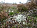
| + | Image:2021-11-13 52 5 FelixTheCat 3.JPG | Autumn means mushrooms everywhere. Not sure what type this is though. | ||
| + | Image:2021-11-13 52 5 FelixTheCat 4.JPG | The view from a small hill, showing the sandy area all around. | ||
| + | Image:2021-11-13 52 5 FelixTheCat 5.JPG | The hash is straight ahead, behind this decomposing tree. | ||
| + | Image:2021-11-13 52 5 FelixTheCat 6.JPG | Right here! | ||
| + | Image:2021-11-13 52 5 FelixTheCat 8.png | GPS proof. | ||
| + | Image:2021-11-13 52 5 FelixTheCat 7.JPG | Lloyd and Trix celebrating. | ||
| + | Image:2021-11-13 52 5 FelixTheCat 9.JPG | A view from the hash. Heath and low shrubs everywhere. | ||
| + | Image:2021-11-13 52 5 FelixTheCat 10.JPG | Reindeer moss (probably ''Cladonia portentosa'') grows here too. | ||
</gallery> | </gallery> | ||
== Achievements == | == Achievements == | ||
{{#vardefine:ribbonwidth|800px}} | {{#vardefine:ribbonwidth|800px}} | ||
| − | + | {{land geohash | |
| − | + | | latitude = 52 | |
| − | + | | longitude = 5 | |
| − | + | | date = 2021-11-13 | |
| − | + | | name = [[User:FelixTheCat|FelixTheCat]] ([[User talk:FelixTheCat|talk]]) | |
| − | + | }} | |
| − | |||
| − | |||
| − | |||
| − | |||
| − | |||
| − | |||
| − | |||
| − | |||
| − | |||
| − | |||
[[Category:Expeditions]] | [[Category:Expeditions]] | ||
| − | |||
[[Category:Expeditions with photos]] | [[Category:Expeditions with photos]] | ||
| − | |||
| − | |||
| − | |||
| − | |||
| − | |||
[[Category:Coordinates reached]] | [[Category:Coordinates reached]] | ||
| − | |||
| − | |||
| − | |||
| − | |||
| − | |||
| − | |||
| − | |||
| − | |||
| − | |||
| − | |||
| − | |||
| − | |||
| − | |||
| − | |||
| − | |||
| − | |||
| − | |||
| − | |||
Revision as of 19:41, 13 November 2021
| Sat 13 Nov 2021 in 52,5: 52.3439570, 5.7435236 geohashing.info google osm bing/os kml crox |
Location
On heathland near Nunspeet, Gelderland province.
Participants
Expedition
Today's hash was on heathland, near Nunspeet on the northern edge of the Veluwe area. The Veluwe is well-known for its beautiful landscape, so I decided to drive all the way to Nunspeet and then walk to the hash. The nearest car park was more than 2 km away, so I had to walk for about twenty minutes to reach the point. Luckily, the weather was fine; it had been raining earlier, but right now it was just cloudy. My walk started in a forest, but the trees quickly gave way to reveal a desert-like landscape of sand dunes. After feeling like Felix of Arabia for a few minutes, the surroundings changed again to a vast heathland. It was quite refreshing to be in a wide open area nearly devoid of human activity, in such a crowded little country like the Netherlands. I found the hashpoint about 30 metres off a footpath, so I treaded carefully so as not to damage any vegetation. I took pictures and then walked around some more. After returning to the hashmobile I made my way to the town of Nunspeet to have lunch and visit the local museum.
Photos
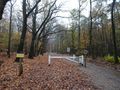
The entrance to the forest.
After the trees come the sand dunes.
Autumn means mushrooms everywhere. Not sure what type this is though.
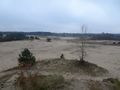
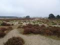
The view from a small hill, showing the sandy area all around.
The hash is straight ahead, behind this decomposing tree.
Right here!
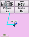
GPS proof.
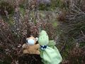
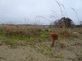
Lloyd and Trix celebrating.
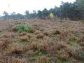
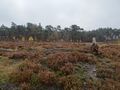
A view from the hash. Heath and low shrubs everywhere.
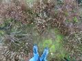
Reindeer moss (probably Cladonia portentosa) grows here too.


Achievements
FelixTheCat (talk) earned the Land geohash achievement
|