Difference between revisions of "2021-11-13 52 9"
m (user categories) |
|||
| Line 32: | Line 32: | ||
[[Category:Expeditions with photos]] | [[Category:Expeditions with photos]] | ||
{{location|DE|NI|H}} | {{location|DE|NI|H}} | ||
| − | + | {{user categories|user=Fippe|bike=17}} | |
Revision as of 00:36, 6 January 2022
| Sat 13 Nov 2021 in 52,9: 52.3439570, 9.7435236 geohashing.info google osm bing/os kml crox |
Location
This Geohash is located on the the grounds of a rowing club in Hannover-Döhren.
Participants
Expedition
I went in the morning since I won't have been able to go at 16:00. It rained as I cycled there.
The site of a Geohash is a bit of a peninsula, being enclosed by the river Leine from the northwest, west and south, and a railway passing by in the northeast. Naturally, I tried to get there any other person would, from the southeast where a path leads to the clubhouse. I knew about the gate, but had hoped that it might be open, but it wasn't, so I didn't reach the coordinates.
In order to take more pictures, I went around the site. The closest I got to the coordinates was 60m to the northeast, where the railway blocked me from getting closer. The only time I got a reasonably good look of the coordinates was 80m to the northeast, with the river Leine in-between. I did not see much from the south, just bushes on the other side of the river. Afterwards, I cycled to a gathering where I would spend most of the rest of the day.
Photos
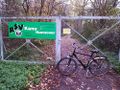
No public access 180m southeast of the coordinates
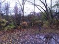
Closest approach 60m northeast of the coordinates. @52.3445,9.7440
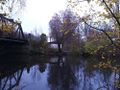
80m northwest of the coordinates
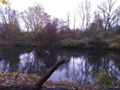
170m south of the coordinates


Achievements
Fippe earned the No trespassing consolation prize
|
Is it true that this user earned the Drowned Rat Geohash Honourable Mention?
|