Difference between revisions of "2021-11-20 51 9"
From Geohashing
(Created page with "{{meetup graticule | lat=51 | lon=9 | date=2021-11-20 }} <!-- edit as necessary --> __NOTOC__ == Location == In a forest north of Barlissen == Participants == User:Digip...") |
|||
| Line 20: | Line 20: | ||
== Expedition == | == Expedition == | ||
<!-- how it all turned out. your narrative goes here. --> | <!-- how it all turned out. your narrative goes here. --> | ||
| + | Since I took a different route as planned, I somehow ended up north from the geohash, near the city of Jühnde, and parked my car along the L559. From there, it were some straight 1500 meters to the hash - first through some fields, after that through the woods and I reached the hash location after some 20 minutes. I had to go off the path some 25 meters, did the usual hashdance and spotted todays hash as a large tree, where I had a pretty good accuracy. | ||
== Photos == | == Photos == | ||
| − | |||
<gallery> | <gallery> | ||
| − | Image:2021-11-20_51_9_001.jpg|On my way to the hash | + | Image:2021-11-20_51_9_001.jpg|On my way to the hash - fields |
| − | Image:2021-11-20_51_9_002.jpg| | + | Image:2021-11-20_51_9_002.jpg|On my way to the hash - forest |
| − | Image:2021-11-20_51_9_003.jpg|The hash | + | Image:2021-11-20_51_9_003.jpg|The hash location |
| − | Image:2021-11-20_51_9_004 | + | Image:2021-11-20_51_9_004.jpg|The hasher at the hash location |
| − | + | Image:2021-11-20_51_9_005.jpg|Proof | |
| − | Image:2021-11- | ||
| − | |||
| − | |||
</gallery> | </gallery> | ||
| Line 38: | Line 35: | ||
[[Category:Coordinates reached]] | [[Category:Coordinates reached]] | ||
{{location|DE|NI|GÖ}} | {{location|DE|NI|GÖ}} | ||
| − | |||
Latest revision as of 16:30, 20 November 2021
| Sat 20 Nov 2021 in 51,9: 51.4505570, 9.8201584 geohashing.info google osm bing/os kml crox |
Location
In a forest north of Barlissen
Participants
Plans
Drive to Barlissen by car and do a walk through the forest to the geohash.
Expedition
Since I took a different route as planned, I somehow ended up north from the geohash, near the city of Jühnde, and parked my car along the L559. From there, it were some straight 1500 meters to the hash - first through some fields, after that through the woods and I reached the hash location after some 20 minutes. I had to go off the path some 25 meters, did the usual hashdance and spotted todays hash as a large tree, where I had a pretty good accuracy.
Photos
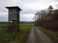
On my way to the hash - fields
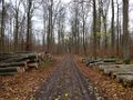
On my way to the hash - forest
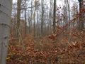
The hash location
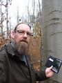
The hasher at the hash location
Proof


