Difference between revisions of "2021-11-28 51 4"
FelixTheCat (talk | contribs) (Created page with "{{subst:Expedition |lat = 51 |lon = 4 |date = 2021-11-28 }}") |
FelixTheCat (talk | contribs) |
||
| Line 1: | Line 1: | ||
| − | + | {{meetup graticule | |
| − | |||
| − | |||
| − | |||
| − | |||
| − | |||
| − | |||
| − | |||
| − | |||
| lat=51 | | lat=51 | ||
| lon=4 | | lon=4 | ||
| Line 14: | Line 6: | ||
__NOTOC__ | __NOTOC__ | ||
== Location == | == Location == | ||
| − | + | Vrachelse Heide, just outside Oosterhout, North Brabant province. | |
== Participants == | == Participants == | ||
| − | + | * [[User:FelixTheCat|FelixTheCat]] ([[User talk:FelixTheCat|talk]]) | |
| − | + | * Kat The Awesome | |
| − | |||
| − | |||
| − | |||
== Expedition == | == Expedition == | ||
| − | + | Kat and I decided to go for a walk in the forest and pick up this hash point. The weather wasn't great, but at least it wasn't raining. We arrived at a car park about 1 km from the hash and walked the remaining distance. The forest was full of fallen leaves and mushrooms. The point was about 50 metres off a footpath, but still quite easy to reach. We took some photos, walked around a bit more and then went home again. | |
| − | |||
| − | |||
| − | |||
== Photos == | == Photos == | ||
| Line 34: | Line 20: | ||
--> | --> | ||
<gallery perrow="5"> | <gallery perrow="5"> | ||
| + | Image:2021-11-28_51_4_FelixTheCat_1.JPG | The path into the forest. | ||
| + | Image:2021-11-28_51_4_FelixTheCat_2.JPG | The groundwater below the forest is used to make drinking water. This structure here is a water monitoring site. | ||
| + | Image:2021-11-28_51_4_FelixTheCat_3.JPG | The hash is right ahead from here. | ||
| + | Image:2021-11-28_51_4_FelixTheCat_4.JPG | Lots of mushrooms everywhere, even on the trees. | ||
| + | Image:2021-11-28_51_4_FelixTheCat_5.JPG | The hashtree. | ||
| + | Image:2021-11-28_51_4_FelixTheCat_6.png | GPS proof. | ||
| + | Image:2021-11-28_51_4_FelixTheCat_7.JPG | Lloyd and Harriet celebrating. | ||
</gallery> | </gallery> | ||
== Achievements == | == Achievements == | ||
{{#vardefine:ribbonwidth|800px}} | {{#vardefine:ribbonwidth|800px}} | ||
| − | + | {{land geohash | |
| − | + | | latitude = 51 | |
| − | + | | longitude = 4 | |
| − | + | | date = 2021-11-28 | |
| − | + | | name = [[User:FelixTheCat|FelixTheCat]] ([[User talk:FelixTheCat|talk]]) and Kat | |
| − | + | }} | |
| − | |||
| − | |||
| − | |||
| − | |||
| − | [[ | ||
| − | |||
| − | |||
| − | |||
| − | |||
| − | |||
[[Category:Expeditions]] | [[Category:Expeditions]] | ||
| − | |||
[[Category:Expeditions with photos]] | [[Category:Expeditions with photos]] | ||
| − | |||
| − | |||
| − | |||
| − | |||
| − | |||
[[Category:Coordinates reached]] | [[Category:Coordinates reached]] | ||
| − | |||
| − | |||
| − | |||
| − | |||
| − | |||
| − | |||
| − | |||
| − | |||
| − | |||
| − | |||
| − | |||
| − | |||
| − | |||
| − | |||
| − | |||
| − | |||
| − | |||
| − | |||
Revision as of 18:44, 2 December 2021
| Sun 28 Nov 2021 in 51,4: 51.6356320, 4.8286788 geohashing.info google osm bing/os kml crox |
Location
Vrachelse Heide, just outside Oosterhout, North Brabant province.
Participants
- FelixTheCat (talk)
- Kat The Awesome
Expedition
Kat and I decided to go for a walk in the forest and pick up this hash point. The weather wasn't great, but at least it wasn't raining. We arrived at a car park about 1 km from the hash and walked the remaining distance. The forest was full of fallen leaves and mushrooms. The point was about 50 metres off a footpath, but still quite easy to reach. We took some photos, walked around a bit more and then went home again.
Photos
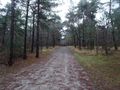
The path into the forest.
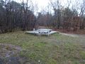
The groundwater below the forest is used to make drinking water. This structure here is a water monitoring site.
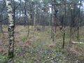
The hash is right ahead from here.
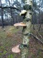
Lots of mushrooms everywhere, even on the trees.
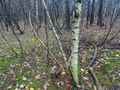
The hashtree.
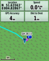
GPS proof.
Lloyd and Harriet celebrating.


Achievements
FelixTheCat (talk) and Kat earned the Land geohash achievement
|