Difference between revisions of "2021-12-22 45 5"
From Geohashing
(→Expedition) |
(→Expedition) |
||
| Line 19: | Line 19: | ||
== Expedition == | == Expedition == | ||
| − | Thick fog in the morning (the Rhône flows nearby). Take advantage of the opportunity to take [https://commons.wikimedia.org/wiki/Category: | + | Thick fog in the morning (the Rhône flows nearby). Take advantage of the opportunity to take [https://commons.wikimedia.org/wiki/Category:Geohashing_2021-12-22_45_5 (Benoît Prieur) some photos for Wikimedia Commons] (nature and center of Jons, old station and town hall), contribute to OpenStreetMap (center of Jons) and make a [https://www.inaturalist.org/observations/103460571 contribution to iNaturalist]. |
== Photos == | == Photos == | ||
Revision as of 16:32, 22 December 2021
| Wed 22 Dec 2021 in Grenoble: 45.7967124, 5.0728107 geohashing.info google osm bing/os kml crox |
Location
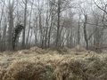
Near Jons, in the countryside, in a little wood. Very close to the route of the A432 motorway and a TGV railway line. A ditch (stream) near the wood (to be mapped on OSM).
Plans
By car, the last hundred meters on foot.
Participants
Expedition
Thick fog in the morning (the Rhône flows nearby). Take advantage of the opportunity to take (Benoît Prieur) some photos for Wikimedia Commons (nature and center of Jons, old station and town hall), contribute to OpenStreetMap (center of Jons) and make a contribution to iNaturalist.
Photos
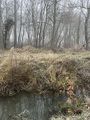
Ruisseau de la Chana (Ratapon)
.jpeg)
.jpeg)
Achievements
Benoît Prieur earned the Land geohash achievement
|
Benoît Prieur earned the OpenStreetMap achievement
|