Difference between revisions of "2021-12-25 46 4"
From Geohashing
(→Expedition) |
(→Expedition: laspus:)) |
||
| (6 intermediate revisions by the same user not shown) | |||
| Line 17: | Line 17: | ||
== Expedition == | == Expedition == | ||
| − | Thick fog in the morning (again). Take advantage of the opportunity to take [https://commons.wikimedia.org/wiki/Category:Geohashing_2021-12-25_46_4_(Benoît_Prieur) some photos for Wikimedia Commons], contribute to OpenStreetMap and | + | Thick fog in the morning (again). Take advantage of the opportunity to take [https://commons.wikimedia.org/wiki/Category:Geohashing_2021-12-25_46_4_(Benoît_Prieur) some photos for Wikimedia Commons], contribute to OpenStreetMap and add a [https://www.pss-archi.eu/immeubles/FR-01005-80731.html new building in construction] to ''PSS-archi''. |
== Photos == | == Photos == | ||
<gallery perrow="4"> | <gallery perrow="4"> | ||
| + | 2021-12-25 46 4 (1).jpeg| Chalaronne River. | ||
| + | 2021-12-25 46 4 (2).jpeg | ||
| + | 2021-12-25 46 4 (3).jpeg| Chalaronne River. | ||
</gallery> | </gallery> | ||
| Line 30: | Line 33: | ||
| date = 2021-12-25 | | date = 2021-12-25 | ||
| name = Benoît Prieur | | name = Benoît Prieur | ||
| + | }} | ||
| + | {{OpenStreetMap achievement | ||
| + | | latitude = 46 | ||
| + | | longitude = 4 | ||
| + | | date = 2021-12-25 | ||
| + | | OSMlink = 115356459 | ||
| + | | OSMlink2 = 115356784 | ||
| + | | OSMlink3 = 115357737 | ||
| + | | name = Benoît Prieur | ||
| + | | image = 2021-12-25 46 4 (1).jpeg | ||
}} | }} | ||
Latest revision as of 12:43, 25 December 2021
| Sat 25 Dec 2021 in Chalon-sur-Saône: 46.1422329, 4.8718674 geohashing.info google osm bing/os kml crox |
Location
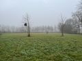
At the end of a path called "Impasse des Pêcheurs", in a small meadow, near the course of the Chalaronne river.
Plans
By car.
Participants
Expedition
Thick fog in the morning (again). Take advantage of the opportunity to take some photos for Wikimedia Commons, contribute to OpenStreetMap and add a new building in construction to PSS-archi.
Photos
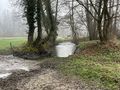
Chalaronne River.
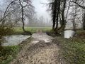
Chalaronne River.
.jpeg)
.jpeg)
.jpeg)
Achievements
Benoît Prieur earned the Land geohash achievement
|
Benoît Prieur earned the OpenStreetMap achievement
|