Difference between revisions of "2021-12-26 50 8"
m (→Plans) |
(expedition report for Frankfurt am Main) |
||
| Line 1: | Line 1: | ||
| − | + | {{meetup graticule | |
| − | |||
| − | |||
| − | |||
| − | |||
| − | |||
| − | |||
| − | |||
| − | |||
| lat=50 | | lat=50 | ||
| lon=8 | | lon=8 | ||
| Line 14: | Line 6: | ||
__NOTOC__ | __NOTOC__ | ||
== Location == | == Location == | ||
| − | + | ||
| + | The hash lay on a field of steles. On the northern bank of the river Main and on the easter side of the Deutschherrnbrücke, a railway bridge. | ||
== Participants == | == Participants == | ||
| − | + | ||
| − | |||
* [[User:GeorgDerReisende|GeorgDerReisende]] | * [[User:GeorgDerReisende|GeorgDerReisende]] | ||
| + | * [[User:Rincewind|Rincewind]] | ||
| + | * [[User:Yakamoz|Yakamoz]] | ||
| + | * TheOffspring | ||
== Plans == | == Plans == | ||
| Line 27: | Line 22: | ||
== Expedition == | == Expedition == | ||
| − | + | ||
| + | ===GeorgDerReisende=== | ||
| + | |||
| + | I left home at 7:30 and took the Regionalexpress leaving Kasel-Wilhelmshöhe at 8:29 for Frankfurt. In Frankfurt I made a walk in the suburbs. Shortly after the depature I noticed that I had forgotten my preparation sheet on my desk. But I knew my targets by head. Around four o'clock I arrived the field of steles with the hash. I visited each stele with my GPS and later at home I could get proof that I was two times not more away from the hash as 1.3 meters. But I missed some people. Rincewind & Co. has announced themselves at hash o'clock but I was alone. I waited until 16:15, walking around the whole field and just at the moment when I wanted to leave the field, they arrived. Rincewind confirmed the coordinates and found them two meters outside the field. We talked a little, the we departed. I went to the next tram stop, traveled to the main station and with the Regionalexpress leaving Frankfurt at 17:19 I traveled home. | ||
== Tracklog == | == Tracklog == | ||
| Line 36: | Line 34: | ||
Image:2020-##-## ## ## Alpha.jpg | Witty Comment | Image:2020-##-## ## ## Alpha.jpg | Witty Comment | ||
--> | --> | ||
| + | ===GeorgDerReisende=== | ||
| + | |||
| + | <gallery> | ||
| + | File:2021-12-26 50 8 GeorgDerReisende 1.jpg | this is my walk around the field of steles, think about the red line five meters to the west | ||
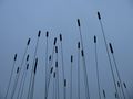
| + | File:2021-12-26 50 8 GeorgDerReisende 5012.jpg | the field of steles | ||
| + | File:2021-12-26 50 8 GeorgDerReisende 5019.jpg | one proof | ||
| + | File:2021-12-26 50 8 GeorgDerReisende 5032.jpg | another proof (best shots) | ||
| + | File:2021-12-26 50 8 GeorgDerReisende 5074.jpg | looking north | ||
| + | File:2021-12-26 50 8 GeorgDerReisende 5075.jpg | west | ||
| + | File:2021-12-26 50 8 GeorgDerReisende 5076.jpg | south | ||
| + | File:2021-12-26 50 8 GeorgDerReisende 5077.jpg | east | ||
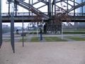
| + | File:2021-12-26 50 8 GeorgDerReisende 5079.jpg | the Deutschherrn-brücke with a train | ||
| + | File:2021-12-26 50 8 GeorgDerReisende 5082.jpg | the EZB | ||
| + | File:2021-12-26 50 8 GeorgDerReisende 5089.jpg | a new house in the northeast | ||
| + | File:2021-12-26 50 8 GeorgDerReisende 5092.jpg | some seconds after my decision to leave | ||
| + | File:2021-12-26 50 8 GeorgDerReisende 5094.jpg | Rincewind looks for the coordinates | ||
| + | File:2021-12-26 50 8 GeorgDerReisende 5096.jpg | four geohashers | ||
| + | </gallery> | ||
| + | |||
| + | |||
<gallery perrow="5"> | <gallery perrow="5"> | ||
</gallery> | </gallery> | ||
| Line 43: | Line 61: | ||
<!-- Add any achievement ribbons you earned below, or remove this section --> | <!-- Add any achievement ribbons you earned below, or remove this section --> | ||
| − | + | {{Meet-up | latitude = 50 | longitude = 8 | date = 2021-12-26 | name = [[User:GeorgDerReisende|GeorgDerReisende]] and [[User:Yakamoz|Yakamoz]] and TheOffspring | other = eachother }} | |
| − | |||
| − | [[ | ||
| − | + | [[Category:Expeditions]] | |
| − | + | [[Category:Expeditions with photos]] | |
| − | |||
| − | |||
| − | |||
| − | |||
| − | |||
| − | |||
| − | |||
| − | |||
| − | |||
| − | |||
| − | |||
| − | |||
| − | |||
| − | |||
[[Category:Coordinates reached]] | [[Category:Coordinates reached]] | ||
| − | |||
| − | |||
| − | |||
| − | |||
| − | |||
| − | |||
| − | |||
| − | |||
| − | |||
| − | |||
| − | |||
| − | |||
| − | |||
| − | |||
| − | |||
| − | |||
| − | |||
| − | |||
Revision as of 18:34, 27 December 2021
| Sun 26 Dec 2021 in 50,8: 50.1075265, 8.7059686 geohashing.info google osm bing/os kml crox |
Location
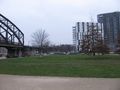
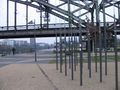
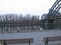
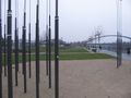
The hash lay on a field of steles. On the northern bank of the river Main and on the easter side of the Deutschherrnbrücke, a railway bridge.
Participants
- GeorgDerReisende
- Rincewind
- Yakamoz
- TheOffspring
Plans
- X-Mas hash! Meet us at 4pm?
Rincewind, Yakamoz, TheOffspring -- Rincewind (talk) 17:55, 23 December 2021 (GMT+01:00)
Expedition
GeorgDerReisende
I left home at 7:30 and took the Regionalexpress leaving Kasel-Wilhelmshöhe at 8:29 for Frankfurt. In Frankfurt I made a walk in the suburbs. Shortly after the depature I noticed that I had forgotten my preparation sheet on my desk. But I knew my targets by head. Around four o'clock I arrived the field of steles with the hash. I visited each stele with my GPS and later at home I could get proof that I was two times not more away from the hash as 1.3 meters. But I missed some people. Rincewind & Co. has announced themselves at hash o'clock but I was alone. I waited until 16:15, walking around the whole field and just at the moment when I wanted to leave the field, they arrived. Rincewind confirmed the coordinates and found them two meters outside the field. We talked a little, the we departed. I went to the next tram stop, traveled to the main station and with the Regionalexpress leaving Frankfurt at 17:19 I traveled home.
Tracklog
Photos
GeorgDerReisende
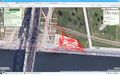
this is my walk around the field of steles, think about the red line five meters to the west
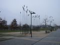
the field of steles
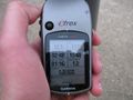
one proof
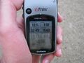
another proof (best shots)
looking north
west
south
east
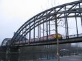
the Deutschherrn-brücke with a train
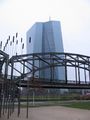
the EZB
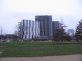
a new house in the northeast
some seconds after my decision to leave
Rincewind looks for the coordinates
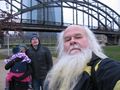
four geohashers


Achievements
GeorgDerReisende and Yakamoz and TheOffspring earned the Meet-up achievement
|