Difference between revisions of "2022-01-01 48 8"
Gefrierbrand (talk | contribs) ([retro picture]start) |
Gefrierbrand (talk | contribs) |
||
| Line 1: | Line 1: | ||
| − | + | {{meetup graticule | |
| − | |||
| − | |||
| − | |||
| − | |||
| − | |||
| − | |||
| − | |||
| − | |||
| lat=48 | | lat=48 | ||
| lon=8 | | lon=8 | ||
| date=2022-01-01 | | date=2022-01-01 | ||
| − | }} | + | }} |
__NOTOC__ | __NOTOC__ | ||
== Location == | == Location == | ||
| − | + | Next to a playground in Karlsruhe | |
== Participants == | == Participants == | ||
| − | + | *[[User:Santu|Santu]] | |
| − | + | *[[User:Gefrierbrand|Gefrierbrand]] | |
| + | *Pedro the dog | ||
| + | *Two dragalongs who wished to remain unnamed | ||
| − | == | + | == Expedition == |
| − | + | We were visiting friends in Karlsruhe and wanted to go out for a walk due to the nice weather and Pedro needing to pee. So we checked for local attractions and quickly disregarded all other plans as soon as we realized the very close proximity (about 2.5 km) of the geohashpoint. | |
| − | + | Thankfully, we were able to walk along the Alb river for most of the way which provided nice views on the local plants and wildlife along its shores instead of boring city streets. Shortly after, it was no problem at all to reach the Hashpoint right in front of a playground. We could use the edge of the nearby lawn which was clearly visible in the areal pictures and conveniently marked by a cornerstone in real live to exactly pinpoint the target location. The GPS position only deviated about 2 Meters from it. | |
| − | < | + | |
| + | While Santu and Gefrierbrand took the StupidGrin<sup>TM</sup> pictures the two dragalongs wandered off claiming to only look ahead for a few minutes. Those minutes passed quickly but nobody returned to the hashsite. After waiting for a bit more and unsuccessfully trying to reach their friends on the phone, Gefrierbrand and Santu started to worry a bit and split up in an effort to locate the missing persons. As one can see nicely on the GPS Tracks, we managed to do an anti-tron route crossing many times while walking bigger and bigger circles around the adjacent houses. | ||
| + | |||
| + | Thankfully, the dragalongs remembered that phones are a thing and called back so we could quickly reunite the group. We then explored a the area a bit more and wandered through a very nice nature preserve. We spotted at least three [https://en.wikipedia.org/wiki/Kingfisher kingfishers] flying close to the water, but did not manage to snap even half-decent pictures of one. | ||
== Tracklog == | == Tracklog == | ||
| − | + | {{tracklog | T2022-01-01-14-03 gh Karlsruhe.gpx}} | |
== Photos == | == Photos == | ||
| − | |||
| − | |||
| − | |||
<gallery perrow="5"> | <gallery perrow="5"> | ||
| − | + | Image:2022-01-01_48_8_Gefrierbrand_1641131763480.jpg|heading out | |
| + | Image:2022-01-01_48_8_Gefrierbrand_1641131736915.jpg|cornerstone | ||
Image:2022-01-01_48_8_Gefrierbrand_1641043117673.jpg|StupidGrin | Image:2022-01-01_48_8_Gefrierbrand_1641043117673.jpg|StupidGrin | ||
| − | + | Image:2022-01-01_48_8_Gefrierbrand_1641131662386.jpg|heading back | |
| + | Image:2022-01-01_48_8_Gefrierbrand_1641131688136.jpg|lots of mistletoe in the trees | ||
| + | Image:2022-01-01_48_8_Gefrierbrand_1641131714832.jpg|nice lake | ||
Image:2022-01-01_48_8_Gefrierbrand_1641043217999.jpg|Proof | Image:2022-01-01_48_8_Gefrierbrand_1641043217999.jpg|Proof | ||
| − | |||
| − | |||
| − | |||
| − | |||
| − | |||
| − | |||
| − | |||
| − | |||
| − | |||
| − | |||
</gallery> | </gallery> | ||
== Achievements == | == Achievements == | ||
{{#vardefine:ribbonwidth|800px}} | {{#vardefine:ribbonwidth|800px}} | ||
| − | + | {{land geohash | |
| + | | latitude = 48 | ||
| + | | longitude = 8 | ||
| + | | date = 2022-01-01 | ||
| + | | name = Gefrierbrand, Santu & Friends | ||
| + | }} | ||
| + | {{drag-along | ||
| + | | latitude = 48 | ||
| + | | longitude = 8 | ||
| + | | date = 2022-01-01 | ||
| + | | name = Gefrierbrand & Santu | ||
| + | }} | ||
| + | {{A Tale of Two Hashes challenge | ||
| + | | latitude = 48 | ||
| + | | longitude = 8 | ||
| + | | date = 2022-01-01 | ||
| + | | name = Gefrierbrand & Santu | ||
| + | | place = [https://en.wikipedia.org/wiki/Karlsruhe_(disambiguation) Karlsruhe] | ||
| + | }} | ||
| − | |||
| − | |||
| − | |||
| − | |||
| − | |||
| − | |||
| − | |||
| − | |||
| − | |||
| − | |||
| − | |||
| − | |||
| − | |||
| − | |||
[[Category:Expeditions]] | [[Category:Expeditions]] | ||
| − | |||
[[Category:Expeditions with photos]] | [[Category:Expeditions with photos]] | ||
| − | |||
| − | |||
| − | |||
| − | |||
| − | |||
[[Category:Coordinates reached]] | [[Category:Coordinates reached]] | ||
| − | |||
| − | |||
| − | |||
| − | |||
| − | |||
| − | |||
| − | |||
| − | |||
| − | |||
| − | |||
| − | |||
| − | |||
| − | |||
| − | |||
| − | |||
| − | |||
| − | |||
| − | |||
Revision as of 14:35, 2 January 2022
| Sat 1 Jan 2022 in 48,8: 48.9990349, 8.3340696 geohashing.info google osm bing/os kml crox |
Location
Next to a playground in Karlsruhe
Participants
- Santu
- Gefrierbrand
- Pedro the dog
- Two dragalongs who wished to remain unnamed
Expedition
We were visiting friends in Karlsruhe and wanted to go out for a walk due to the nice weather and Pedro needing to pee. So we checked for local attractions and quickly disregarded all other plans as soon as we realized the very close proximity (about 2.5 km) of the geohashpoint.
Thankfully, we were able to walk along the Alb river for most of the way which provided nice views on the local plants and wildlife along its shores instead of boring city streets. Shortly after, it was no problem at all to reach the Hashpoint right in front of a playground. We could use the edge of the nearby lawn which was clearly visible in the areal pictures and conveniently marked by a cornerstone in real live to exactly pinpoint the target location. The GPS position only deviated about 2 Meters from it.
While Santu and Gefrierbrand took the StupidGrinTM pictures the two dragalongs wandered off claiming to only look ahead for a few minutes. Those minutes passed quickly but nobody returned to the hashsite. After waiting for a bit more and unsuccessfully trying to reach their friends on the phone, Gefrierbrand and Santu started to worry a bit and split up in an effort to locate the missing persons. As one can see nicely on the GPS Tracks, we managed to do an anti-tron route crossing many times while walking bigger and bigger circles around the adjacent houses.
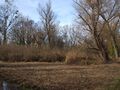
Thankfully, the dragalongs remembered that phones are a thing and called back so we could quickly reunite the group. We then explored a the area a bit more and wandered through a very nice nature preserve. We spotted at least three kingfishers flying close to the water, but did not manage to snap even half-decent pictures of one.
Tracklog
Photos
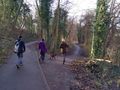
heading out
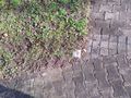
cornerstone

StupidGrin
heading back
lots of mistletoe in the trees
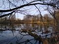
nice lake
Proof


Achievements
Gefrierbrand, Santu & Friends earned the Land geohash achievement
|
Gefrierbrand & Santu earned the Drag-along achievement
|
