Difference between revisions of "2022-01-09 40 -4"
(Created page with "<!-- [[Image:{{{image|IMAGE}}}|thumb|left]] --> <!-- Remove this section if you don't want an image at the top (left) of your report. You should remove the "Image...") |
(→Photos) |
||
| Line 48: | Line 48: | ||
<gallery perrow="5"> | <gallery perrow="5"> | ||
Image:2022-01-09_40_-4_L1040890.JPG | Already close to the geohash, I stop here… | Image:2022-01-09_40_-4_L1040890.JPG | Already close to the geohash, I stop here… | ||
| − | Image:2022-01-09_40_-4_L1040891.JPG | … to take a photo of this 17th century hermitage. | + | Image:2022-01-09_40_-4_L1040891.JPG | … to take a photo of this 17th century hermitage ''Ermita de Nuestra Señora de la Poveda.'' |
Image:2022-01-09_40_-4_L1040892.JPG | Some tens of meters further, the unpaved road narrows. I decide to park the Goldwing here and continue on foot, just 200 meters left to the geohash. | Image:2022-01-09_40_-4_L1040892.JPG | Some tens of meters further, the unpaved road narrows. I decide to park the Goldwing here and continue on foot, just 200 meters left to the geohash. | ||
Image:2022-01-09_40_-4_L1040894.JPG | I am glad that I did not try to continue on the motorcycle. | Image:2022-01-09_40_-4_L1040894.JPG | I am glad that I did not try to continue on the motorcycle. | ||
Revision as of 07:14, 11 January 2022
| Sun 9 Jan 2022 in 40,-4: 40.2808714, -4.2400080 geohashing.info google osm bing/os kml crox |
Location
Behind a fence, on a field near Villa del Prado.
Participants
Plans
Expedition
This one was relatively close, just an about 20 minutes motorcycle ride. I knew the nice route well from previous motorcycle excursions, but I did not yet visit a geohash in that area, so I decided to give it a try.
Unfortunately, the geohash was behind a fence on a field where some plants were already growing. So, I could not reach it, but it was a nice little trip.
Tracklog
Photos
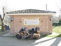
Already close to the geohash, I stop here…
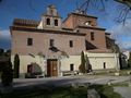
… to take a photo of this 17th century hermitage Ermita de Nuestra Señora de la Poveda.
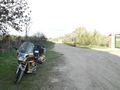
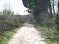
Some tens of meters further, the unpaved road narrows. I decide to park the Goldwing here and continue on foot, just 200 meters left to the geohash.
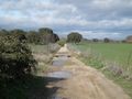
I am glad that I did not try to continue on the motorcycle.
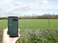
Here it ends this time. The geohash is just 25 meters behind the fence.
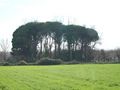
Funny group of trees, looks like broccoli.
The Goldwing is in fact parked next to it, I notice now.
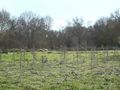
I did not have a photo of thistles for quite some time (last one in expedition 2021-08-28_40_-4), so here is one.


