Difference between revisions of "2022-01-13 63 29"
(Created page with "{{subst:Expedition}}") |
|||
| Line 1: | Line 1: | ||
| − | + | {{meetup graticule | |
| − | |||
| − | |||
| − | |||
| − | |||
| − | |||
| − | |||
| − | |||
| − | |||
| lat={{#explode:{{SUBPAGENAME}}| |1}} | | lat={{#explode:{{SUBPAGENAME}}| |1}} | ||
| lon={{#explode:{{SUBPAGENAME}}| |2}} | | lon={{#explode:{{SUBPAGENAME}}| |2}} | ||
| date={{#explode:{{SUBPAGENAME}}| |0}} | | date={{#explode:{{SUBPAGENAME}}| |0}} | ||
| − | }} | + | }} |
__NOTOC__ | __NOTOC__ | ||
== Location == | == Location == | ||
| − | + | In a forest in Retuniemi, Juuka. | |
| + | |||
| + | The point on a topographic map: {{MapSiteLink | N = 7015639 | E = 614863 | title = Geohash+2022-01-13+63+29}} | ||
== Participants == | == Participants == | ||
| − | + | * [[User:Kripakko|Kripakko]] | |
| − | |||
| − | |||
| − | |||
| − | |||
== Expedition == | == Expedition == | ||
| − | + | I was driving towards the north with my girlfriend with a rental car, and this hashpoint was so conveniently close to the route that I could not just pass it. It was located only 35 metres from a small road that is not visible on OpenStreetMap and only 1.3 kilometres from highway 6. I drove along the road past the hashpoint, turned the car around and parked it on a widening of the road. I walked to the closest point on the road and then the last 35 metres to the hashpoint. Meanwhile my girlfriend waited in the car. There was quite a bit of snow, mostly some 50–60 cm, but this time at +1 °C it was wet snow which did not get in my boots or trousers. At one point I stepped in a hole where there was a metre of snow, but I did not care much. I quickly reached the hashpoint, took a few photos and left. | |
== Tracklog == | == Tracklog == | ||
| − | + | {{tracklog | 2022-01-13_63_29_tracklog.gpx}} | |
== Photos == | == Photos == | ||
| − | |||
| − | |||
| − | |||
<gallery perrow="5"> | <gallery perrow="5"> | ||
| + | Image:2022-01-13_63_29_01-car.jpg | Where I parked the car, 100 m to go. | ||
| + | Image:2022-01-13_63_29_02-gpsr1.jpg | Proof of location. | ||
| + | Image:2022-01-13_63_29_03-gpsr2.jpg | Proof of date and time. | ||
| + | Image:2022-01-13_63_29_04-selfie.jpg | Selfie at the hashpoint. | ||
| + | Image:2022-01-13_63_29_05-hole.jpg | The hole in which I stepped with a metre of snow. The wet snow stayed well out of my boots and trousers. | ||
</gallery> | </gallery> | ||
== Achievements == | == Achievements == | ||
{{#vardefine:ribbonwidth|800px}} | {{#vardefine:ribbonwidth|800px}} | ||
| − | + | {{land geohash | name = Kripakko | latitude = 63 | longitude = 29 | date = 2022-01-13}} | |
| − | |||
| − | |||
| − | |||
| − | |||
| − | |||
| − | |||
| − | |||
| − | |||
| − | |||
| − | |||
| − | |||
| − | |||
| − | |||
| − | |||
[[Category:Expeditions]] | [[Category:Expeditions]] | ||
| − | |||
[[Category:Expeditions with photos]] | [[Category:Expeditions with photos]] | ||
| − | |||
| − | |||
| − | |||
| − | |||
| − | |||
[[Category:Coordinates reached]] | [[Category:Coordinates reached]] | ||
| − | |||
| − | |||
| − | |||
| − | |||
| − | |||
| − | |||
| − | |||
| − | |||
| − | |||
| − | |||
| − | |||
| − | |||
| − | |||
| − | |||
| − | |||
| − | |||
| − | |||
| − | |||
Revision as of 19:21, 13 January 2022
| Thu 13 Jan 2022 in 63,29: 63.2513163, 29.2877152 geohashing.info google osm bing/os kml crox |
Location
In a forest in Retuniemi, Juuka.
The point on a topographic map: [1]
Participants
Expedition
I was driving towards the north with my girlfriend with a rental car, and this hashpoint was so conveniently close to the route that I could not just pass it. It was located only 35 metres from a small road that is not visible on OpenStreetMap and only 1.3 kilometres from highway 6. I drove along the road past the hashpoint, turned the car around and parked it on a widening of the road. I walked to the closest point on the road and then the last 35 metres to the hashpoint. Meanwhile my girlfriend waited in the car. There was quite a bit of snow, mostly some 50–60 cm, but this time at +1 °C it was wet snow which did not get in my boots or trousers. At one point I stepped in a hole where there was a metre of snow, but I did not care much. I quickly reached the hashpoint, took a few photos and left.
Tracklog
Photos
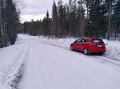
Where I parked the car, 100 m to go.
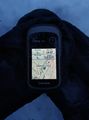
Proof of location.
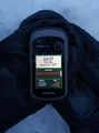
Proof of date and time.
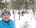
Selfie at the hashpoint.
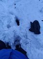
The hole in which I stepped with a metre of snow. The wet snow stayed well out of my boots and trousers.


Achievements
Kripakko earned the Land geohash achievement
|