Difference between revisions of "2022-01-15 61 22"
FelixTheCat (talk | contribs) (Created page with "{{subst:Expedition |lat = 61 |lon = 22 |date = 2022-01-15 }}") |
FelixTheCat (talk | contribs) |
||
| Line 1: | Line 1: | ||
| − | + | {{meetup graticule | |
| − | |||
| − | |||
| − | |||
| − | |||
| − | |||
| − | |||
| − | |||
| − | |||
| lat=61 | | lat=61 | ||
| lon=22 | | lon=22 | ||
| date=2022-01-15 | | date=2022-01-15 | ||
| − | }} | + | }} |
__NOTOC__ | __NOTOC__ | ||
== Location == | == Location == | ||
| − | + | In a forest outside Eura, Satakunta region, Finland. | |
== Participants == | == Participants == | ||
| − | + | * [[User:FelixTheCat|FelixTheCat]] ([[User talk:FelixTheCat|talk]]) | |
| − | + | * Kat the Awesome | |
| − | |||
| − | |||
| − | |||
== Expedition == | == Expedition == | ||
| − | + | Kat and I were travelling in Finland. Today we were driving from Helsinki to Rauma, and found that this hash would require just a short detour. We turned off the main road in Eura, continued onto smaller local roads and finally ended up at Balkanintie, a forest road leading to the hash. Fortunately that road was still accessible even in winter, and we drove down it until we came as close as we could. At that point the hash was still about 400 metres away, so we parked the hashmobile and continued on foot. Although the remaining distance was not so great, it still took us about twenty minutes because the forest was covered in about 30 cm of snow and there were no paths. We finally did find the point, took some pictures and admired the beauty of the surroundings and the setting sun. We then went back on the road and drove on to Rauma. | |
| − | |||
| − | |||
| − | |||
== Photos == | == Photos == | ||
| − | |||
| − | |||
| − | |||
<gallery perrow="5"> | <gallery perrow="5"> | ||
| + | Image:2022-01-15 61 22 FelixTheCat 1.JPG | At first we were afraid this road might not be accessible without an off-road vehicle, but it seems all right from here. | ||
| + | Image:2022-01-15 61 22 FelixTheCat 2.JPG | We parked the rental hashmobile at the side of the road. | ||
| + | Image:2022-01-15 61 22 FelixTheCat 3.JPG | The "path" leading into the forest. | ||
| + | Image:2022-01-15 61 22 FelixTheCat 4.JPG | There's a layer of snow, with lots of animal tracks. | ||
| + | Image:2022-01-15 61 22 FelixTheCat 5.JPG | The trees become smaller here, but the ground is very uneven making it hard to walk. | ||
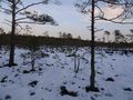
| + | Image:2022-01-15 61 22 FelixTheCat 6.JPG | The hash is up ahead, where the trees are bigger. | ||
| + | Image:2022-01-15 61 22 FelixTheCat 8.JPG | Right here! Lloyd is happy, but doesn't want to sit on the ground. | ||
| + | Image:2022-01-15 61 22 FelixTheCat 7.png | GPS proof. | ||
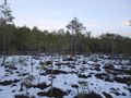
| + | Image:2022-01-15 61 22 FelixTheCat 9.JPG | The surroundings. The sun is beginning to set, because it's already three o'clock. | ||
</gallery> | </gallery> | ||
== Achievements == | == Achievements == | ||
{{#vardefine:ribbonwidth|800px}} | {{#vardefine:ribbonwidth|800px}} | ||
| − | + | {{land geohash | |
| − | + | | latitude = 61 | |
| − | + | | longitude = 22 | |
| − | + | | date = 2022-01-15 | |
| − | [[ | + | | name = [[User:FelixTheCat|FelixTheCat]] ([[User talk:FelixTheCat|talk]]) and Kat |
| − | + | }} | |
| − | |||
| − | |||
| − | |||
| − | |||
[[Category:Expedition planning]] | [[Category:Expedition planning]] | ||
| − | |||
| − | |||
| − | |||
| − | |||
| − | |||
[[Category:Expeditions]] | [[Category:Expeditions]] | ||
| − | |||
[[Category:Expeditions with photos]] | [[Category:Expeditions with photos]] | ||
| − | |||
| − | |||
| − | |||
| − | |||
| − | |||
[[Category:Coordinates reached]] | [[Category:Coordinates reached]] | ||
| − | |||
| − | |||
| − | |||
| − | |||
| − | |||
| − | |||
| − | |||
| − | |||
| − | |||
| − | |||
| − | |||
| − | |||
| − | |||
| − | |||
| − | |||
| − | |||
| − | |||
| − | |||
Revision as of 11:07, 22 January 2022
| Sat 15 Jan 2022 in 61,22: 61.1806112, 22.0036901 geohashing.info google osm bing/os kml crox |
Location
In a forest outside Eura, Satakunta region, Finland.
Participants
- FelixTheCat (talk)
- Kat the Awesome
Expedition
Kat and I were travelling in Finland. Today we were driving from Helsinki to Rauma, and found that this hash would require just a short detour. We turned off the main road in Eura, continued onto smaller local roads and finally ended up at Balkanintie, a forest road leading to the hash. Fortunately that road was still accessible even in winter, and we drove down it until we came as close as we could. At that point the hash was still about 400 metres away, so we parked the hashmobile and continued on foot. Although the remaining distance was not so great, it still took us about twenty minutes because the forest was covered in about 30 cm of snow and there were no paths. We finally did find the point, took some pictures and admired the beauty of the surroundings and the setting sun. We then went back on the road and drove on to Rauma.
Photos
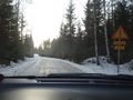
At first we were afraid this road might not be accessible without an off-road vehicle, but it seems all right from here.
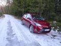
We parked the rental hashmobile at the side of the road.
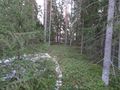
The "path" leading into the forest.
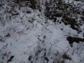
There's a layer of snow, with lots of animal tracks.
The trees become smaller here, but the ground is very uneven making it hard to walk.
The hash is up ahead, where the trees are bigger.
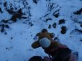
Right here! Lloyd is happy, but doesn't want to sit on the ground.
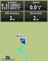
GPS proof.
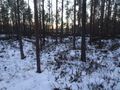
The surroundings. The sun is beginning to set, because it's already three o'clock.


Achievements
FelixTheCat (talk) and Kat earned the Land geohash achievement
|