Difference between revisions of "2022-01-23 61 29"
(Created page with "{{subst:Expedition}}") |
|||
| Line 1: | Line 1: | ||
| − | + | {{meetup graticule | |
| − | |||
| − | |||
| − | |||
| − | |||
| − | |||
| − | |||
| − | |||
| − | |||
| lat={{#explode:{{SUBPAGENAME}}| |1}} | | lat={{#explode:{{SUBPAGENAME}}| |1}} | ||
| lon={{#explode:{{SUBPAGENAME}}| |2}} | | lon={{#explode:{{SUBPAGENAME}}| |2}} | ||
| date={{#explode:{{SUBPAGENAME}}| |0}} | | date={{#explode:{{SUBPAGENAME}}| |0}} | ||
| − | }} | + | }} |
__NOTOC__ | __NOTOC__ | ||
== Location == | == Location == | ||
| − | + | In lake Simpelejärvi, close to the shore near Savikumpu. | |
| + | |||
| + | The point on a topographic map: {{MapSiteLink | N = 6832565 | E = 635365 | title = Geohash+2022-01-23+61+29 }} | ||
== Participants == | == Participants == | ||
| − | + | * [[User:Kripakko|Kripakko]] | |
| − | + | * Kripakko's father | |
== Plans == | == Plans == | ||
| − | + | We were visiting my grandparents who live somewhere in this area, and this point happened to be in an accessible location. I do not want to reveal their home location, so let us just say that the distance to the geohash was less than five kilometres. | |
| − | == Expedition == | + | == Expedition 1 == |
| − | |||
| − | == | + | We went for a reconnaissance trip by car. We did not know whether the road would be clear of snow all the way to the shore, but we would find out. Apparently this place is used as a launching spot for boats and as a snowmobile route by the locals, so the road was well drivable. We parked the car at the shore and needed to walk only 30 metres to get to the geohash. I shovelled the spot of the hashpoint clear of snow to show that there was lake ice underneath. I took a few photos, and then we left. |
| − | + | ||
| + | == Expedition 2 == | ||
| + | |||
| + | For fun and some physical exercise, after we returned to the grandparents' place, I grabbed a kicksled and rode the way to the hashpoint another time. I had no problem traversing the roads, but then I could not quite ride all the way to the hashpoint since there was too much snow. I had to push and nearly carry the kicksled for the last few metres. In retrospect, I could have shovelled a wide enough path in the snow, but it is too late now. Oh well, close enough. I took a few more photos and left again for good. | ||
| + | |||
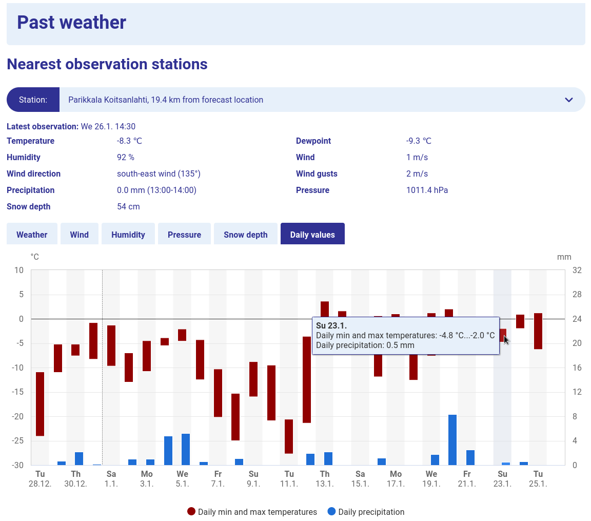
| + | I did not record the temperature, but the Finnish Meteorological Institute [https://en.ilmatieteenlaitos.fi/local-weather/parikkala/savikumpu?parameter=daily] reports a daily high temperature of −2 °C in Koitsanlahti, Parikkala, so it was most definitely freezing. The data of each day disappear in four weeks, so I took a screenshot for permanent proof: [[Media:2022-01-23_61_29_08-temperature.png]]. | ||
== Photos == | == Photos == | ||
| − | <!-- | + | <!-- <gallery perrow="5"> |
| − | + | </gallery> --> | |
| − | --> | + | Will be uploaded later... |
| − | < | + | |
| − | </ | + | == Video == |
| + | <!-- description --> | ||
| + | |||
| + | <youtube>https://youtu.be/UQBMmojYSJw</youtube> | ||
| + | |||
| + | YouTube link: [https://www.youtube.com/watch?v=UQBMmojYSJw] | ||
== Achievements == | == Achievements == | ||
| Line 43: | Line 46: | ||
Delete the next line ONLY if you have chosen the appropriate categories below. If you are unsure, don't worry. People will read your report and help you with the classification. --> | Delete the next line ONLY if you have chosen the appropriate categories below. If you are unsure, don't worry. People will read your report and help you with the classification. --> | ||
[[Category:New report]] | [[Category:New report]] | ||
| + | |||
| + | {{water geohash | latitude = 61 | longitude = 29 | date = 2022-01-23 | name = Kripakko | vehicle = kicksled}} | ||
| + | {{Walking on water geohash | latitude = 61 | longitude = 29 | date = 2022-01-23 | name = Kripakko}} | ||
| + | {{frozen geohash | latitude = 61 | longitude = 29 | date = 2022-01-23 | name = Kripakko}} | ||
<!-- ==REQUEST FOR TWITTER BOT== Please leave either the New report or the Expedition planning category in as long as you work on it. This helps the twitter bot a lot with announcing the right outcome at the right moment. --> | <!-- ==REQUEST FOR TWITTER BOT== Please leave either the New report or the Expedition planning category in as long as you work on it. This helps the twitter bot a lot with announcing the right outcome at the right moment. --> | ||
Revision as of 13:54, 26 January 2022
| Sun 23 Jan 2022 in 61,29: 61.6026188, 29.5517225 geohashing.info google osm bing/os kml crox |
Location
In lake Simpelejärvi, close to the shore near Savikumpu.
The point on a topographic map: [1]
Participants
- Kripakko
- Kripakko's father
Plans
We were visiting my grandparents who live somewhere in this area, and this point happened to be in an accessible location. I do not want to reveal their home location, so let us just say that the distance to the geohash was less than five kilometres.
Expedition 1
We went for a reconnaissance trip by car. We did not know whether the road would be clear of snow all the way to the shore, but we would find out. Apparently this place is used as a launching spot for boats and as a snowmobile route by the locals, so the road was well drivable. We parked the car at the shore and needed to walk only 30 metres to get to the geohash. I shovelled the spot of the hashpoint clear of snow to show that there was lake ice underneath. I took a few photos, and then we left.
Expedition 2
For fun and some physical exercise, after we returned to the grandparents' place, I grabbed a kicksled and rode the way to the hashpoint another time. I had no problem traversing the roads, but then I could not quite ride all the way to the hashpoint since there was too much snow. I had to push and nearly carry the kicksled for the last few metres. In retrospect, I could have shovelled a wide enough path in the snow, but it is too late now. Oh well, close enough. I took a few more photos and left again for good.
I did not record the temperature, but the Finnish Meteorological Institute [2] reports a daily high temperature of −2 °C in Koitsanlahti, Parikkala, so it was most definitely freezing. The data of each day disappear in four weeks, so I took a screenshot for permanent proof: Media:2022-01-23_61_29_08-temperature.png.
Photos
Will be uploaded later...
Video
YouTube link: [3]
Achievements
Kripakko earned the Water geohash achievement
|
Kripakko earned the Walking on water geohash achievement
|
