Difference between revisions of "2022-02-17 53 10"
MikroKosmos (talk | contribs) (→MikroKosmos) |
m |
||
| (3 intermediate revisions by one other user not shown) | |||
| Line 44: | Line 44: | ||
===MikroKosmos=== | ===MikroKosmos=== | ||
<gallery> | <gallery> | ||
| − | + | File:uK20220217_53_10a.jpg | the fence | |
| − | + | File:uK20220217_53_10b.jpg | 1 m distance | |
| − | + | File:uK20220217_53_10c.jpg | @ hash | |
| − | + | File:uK20220217_53_10d.jpg | overview | |
</gallery> | </gallery> | ||
| Line 58: | Line 58: | ||
[[Category:Bicycle geohash achievement]] | [[Category:Bicycle geohash achievement]] | ||
[[Category:Expeditions]] | [[Category:Expeditions]] | ||
| − | {{location|DE | + | {{location|DE|HH}} |
Latest revision as of 16:09, 19 February 2022
| Thu 17 Feb 2022 in 53,10: 53.7087983, 10.0755839 geohashing.info google osm bing/os kml crox |
Location
on uncultivated land in northern Hamburg
Participants
Plans
MikroKosmos
Yesterday: "The location is only about 5 km from my home. Fine!"
Today: "The weather is very bad. Shall I really go for it?"
Expedition
MikroKosmos
N 53°42.528 E 10°04.535 - the location is only about 5 km from my home. But during the last night there was a strong storm and today it rained a lot nearly all day! So I really didn't know, wether it was a good idea to go for this hash.
But then I thought: "Why not? Go!" I put on sports attire and rainwear, including rubber boots.
I cycled there with the wind in my back. Therefore this first part was "easy going". The last 300 m on a hiking trail were more difficult - it was very muddy and plashy. I parked my bicycle beneath a tree and started walking across a really swampy meadow.
My rubber boots were the right footwear!! :-)
After 100 m I had to leave the meadow to enter a muddy spinney. Here the old fence around the meadow with 4 rows of rusty barbed wire was the next obstacle. The fence posts were wet and there was no good place to climb over. So I laid down and slid through below it.
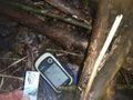
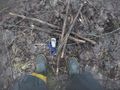
Some meters further between the trees were the hash-coordinates. It took a while, then my gps showed 1-2 m offset. It was ~17:30. I marked the position with crossed sticks and took photos. Besides I scanned the location for any signs or marks of π π π, but didn't see any.
Walking back over the meadow I was happy to have reached this "adventurous" place. On my way back, it started raining and of course, I had strong wind against me. Dampish, but not wet, I reached my home.
.oO( A really nice adventure!)
Photos
MikroKosmos
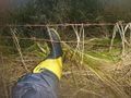
the fence
1 m distance
@ hash
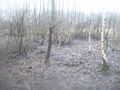
overview


Achievements
MikroKosmos
Land geohash, Bicycle geohash