Difference between revisions of "2022-02-24 -38 146"
From Geohashing
Felix Dance (talk | contribs) (Wrong Graticule) (Tag: Blanking) |
Felix Dance (talk | contribs) (Bad edit) |
||
| Line 1: | Line 1: | ||
| + | [[Image:{{{image|Geohash 2022-02-24 -38 146 03 Hash.jpg}}}|thumb|left]] | ||
| + | {{meetup graticule | ||
| + | | lat=-38 | ||
| + | | lon=146 | ||
| + | | date=2022-02-24 | ||
| + | }} | ||
| + | |||
| + | __NOTOC__ | ||
| + | == Location == | ||
| + | In a field between Churchill and Yinnar. | ||
| + | |||
| + | == Participants == | ||
| + | * [[User:Mdixon4|Mdixon4]] ([[User talk:Mdixon4|talk]]) | ||
| + | |||
| + | == Expedition == | ||
| + | |||
| + | |||
| + | == Tracklog == | ||
| + | {{ Template:Tracklog | }} | ||
| + | |||
| + | == Photos == | ||
| + | <gallery> | ||
| + | File:Geohash 2022-02-24 -38 146 01 Stick.jpg|Hash goes there | ||
| + | File:Geohash 2022-02-24 -38 146 02 Cows.jpg|Curious cows | ||
| + | File:Geohash 2022-02-24 -38 146 03 Hash.jpg|Matt at the hash | ||
| + | </gallery> | ||
| + | |||
| + | |||
| + | == Achievements == | ||
| + | {{#vardefine:ribbonwidth|800px}} | ||
| + | |||
| + | [[Category:Expeditions]] | ||
| + | [[Category:Expeditions with photos]] | ||
| + | [[Category:Coordinates reached]] | ||
| + | {{location|AU|VIC|LA}} | ||
Revision as of 23:48, 26 February 2022

| Thu 24 Feb 2022 in -38,146: -38.3427479, 146.3817264 geohashing.info google osm bing/os kml crox |
Location
In a field between Churchill and Yinnar.
Participants
Expedition
Tracklog
Use the tracklog template like this: {{tracklog|Name of the tracklog file.gpx}}
Photos
Hash goes there
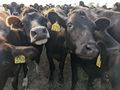
Curious cows
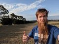
Matt at the hash

