Difference between revisions of "2022-02-24 47 -122"
([live picture]Perfectly good trail too [https://openstreetmap.org/?mlat=47.78041000&mlon=-122.28500900&zoom=16 @47.7804,-122.2850]) |
(Expedition details) |
||
| Line 1: | Line 1: | ||
| − | + | {{meetup graticule | |
| − | |||
| − | |||
| − | |||
| − | |||
| − | |||
| − | |||
| − | |||
| − | |||
| lat=47 | | lat=47 | ||
| lon=-122 | | lon=-122 | ||
| date=2022-02-24 | | date=2022-02-24 | ||
| − | }} | + | | graticule_name=Seattle |
| + | | graticule_link=Seattle, Washington | ||
| + | }} | ||
__NOTOC__ | __NOTOC__ | ||
== Location == | == Location == | ||
| − | + | Possibly part of Abbey View cemetery in Brier | |
== Participants == | == Participants == | ||
| − | + | * [[User:Thomcat|Thomcat]] | |
| − | + | ||
| + | == Expedition == | ||
| + | Aerial photo resembled woods, but sitemap shows it associated with the cemetery. Worth a visit. | ||
| − | + | As I rounded a corner, I realized I had visited this area [[2008-06-30_47_-122|before]]. The cannon was still in place, nice as ever. | |
| − | |||
| − | + | The map shows a pair of diagonal lines leading directly to the hash - not a road, but a gap in the properties? A power line access? I found a perfect parking spot right next to that and spotted the first '''bad sign'''. | |
| − | |||
| − | + | Not trespassing but clarifying, I took a few steps past the road. There was a nice trail leading in the proper direction. Had I seen a caretaker nearby, I would have asked for permission, but instead I headed home. | |
| − | |||
== Photos == | == Photos == | ||
| Line 40: | Line 33: | ||
</gallery> | </gallery> | ||
| − | |||
| − | |||
| − | |||
| − | |||
| − | |||
| − | |||
| − | |||
| − | |||
| − | |||
| − | |||
| − | |||
| − | |||
| − | |||
| − | |||
| − | |||
| − | |||
| − | |||
| − | |||
[[Category:Expeditions]] | [[Category:Expeditions]] | ||
| − | |||
[[Category:Expeditions with photos]] | [[Category:Expeditions with photos]] | ||
| − | |||
| − | |||
| − | |||
| − | |||
| − | |||
| − | |||
| − | |||
| − | |||
| − | |||
[[Category:Coordinates not reached]] | [[Category:Coordinates not reached]] | ||
| − | |||
| − | |||
| − | |||
| − | |||
| − | |||
[[Category:Not reached - No public access]] | [[Category:Not reached - No public access]] | ||
| − | |||
| − | |||
| − | |||
| − | |||
| − | |||
| − | |||
| − | |||
| − | |||
Revision as of 15:50, 25 February 2022
| Thu 24 Feb 2022 in Seattle: 47.7809136, -122.2866132 geohashing.info google osm bing/os kml crox |
Location
Possibly part of Abbey View cemetery in Brier
Participants
Expedition
Aerial photo resembled woods, but sitemap shows it associated with the cemetery. Worth a visit.
As I rounded a corner, I realized I had visited this area before. The cannon was still in place, nice as ever.
The map shows a pair of diagonal lines leading directly to the hash - not a road, but a gap in the properties? A power line access? I found a perfect parking spot right next to that and spotted the first bad sign.
Not trespassing but clarifying, I took a few steps past the road. There was a nice trail leading in the proper direction. Had I seen a caretaker nearby, I would have asked for permission, but instead I headed home.
Photos
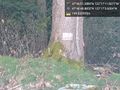
Alas, not a good sign @47.7802,-122.2849
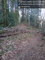
Perfectly good trail too @47.7804,-122.2850

